
User's Manual

Navini Networks, Inc. Ripwave Base Station I&C Guide
Part #40-00047-00 Rev D v1.0 157
February 28, 2003
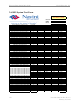
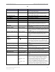
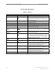
GPS
Field Name Values Description
GPS Latitude
North or South
0 (deg) 0 (min) 0 (sec)
The latitude of the BTS in degrees, minutes, and seconds.
GPS Longitude
East or West
0 (deg) 0 (min) 0 (sec)
The longitude of the BTS in degrees, minutes, and
seconds.
GPS Height (cm)
0 The height of the BTS in centimeters.
GPS Gmt Offset (min)
-360 The difference in time (minutes) between Greenwich
Mean Time (GMT), which is zero, and the time zone
where the BTS is located. For example, if the BTS is
located in Dallas, Texas, the local time is 6 hours earlier
than GMT. In this example, you would enter -360, which
is 6 hrs x 60 mins. If the local time is ahead of GMT, you
would enter a + in front of the number.
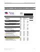
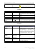
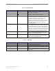
Neighbor BTS Frequency List
Field Name Values Description
Center Frequency (Scroll
Bar)
2.305 GHz - 2.359 GHz
2.40 GHz - 2.473 GHz
2.50 GHz - 2.595 GHz
2.602 - 2.686 GHz
The frequency at which the neighboring BTS is
transmitting.
Colocated
Checkmark or blank Click to place a checkmark indicating that the
neighboring BTS is located on the same tower as the
current BTS.
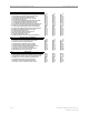
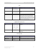
CPE Ping Table
Field Name Values Description
Ping Sequence
0, 1, 2, 3, etc. Order in which the element with this IP address is
pinged.
Ip Address
IP address of the element being added to the Ping Table.
Display String
Alphanumeric (up to 30
characters)
User-assigned designation (name/string) for this element.