
Specifications Chapter 2c

Navini Networks, Inc. Ripwave Base Station I&C Guide
Chapter 2c
Part #40-00047-04 Rev F v1.0 (TTA) 63
October 23, 2003
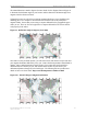
The azimuth direction is stated in degrees from true North. Use the diagram shown in Figure 31
to determine the declination angle for your location. Add or subtract the declination angle from
magnetic North to obtain true North.
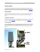
Tighten the four nuts on each of the two antenna mounting brackets to secure the RFS to the
mounting pole. Use a compass to check the direction from the center of the panel (this is
magnetic North). Be sure that you are using a compass calibrated for the geographical region
where you are. There are five such regions and a compass calibrated for one of them will not
work properly in the others.
Figure 31: Declination Angle in Degrees (Year 2000)
Since this is not the year 2000 anymore, you will want to check this reference map to learn how
your magnetic declination shifts from year to year. Notice that the map measures annual shifts in
minutes. Since it takes 60 minutes to equal 1 degree, if you notice that your location has a
declination shift of 5 minutes per year, this means it will be another 12 years before your
declination adjustment changes by one whole degree. The following web site provides more
details on how to use these charts: http://www.thecompassstore.com/decvar.html
Figure 31a: Annual Change in Magnetic Declination