
User manual

19
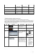
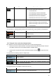
Icon Type More information
Time information
There are time values that can be shown:
x Current GPS time
x Time remaining to reach the destination
x Time remaining to reach the next via point
x Estimated arrival time at the destination
x Estimated arrival time at the next via point
Distance information
There are distance type values that can be shown:
x Distance remaining to reach the destination
x Distance remaining to reach the next via point
x Current altitude
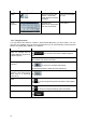
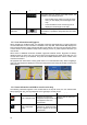
The next area is a combined status indicator field. Tap this area to open the Quick menu (page 57).
Icon Status for More information
GPS position quality
A higher number of lit bars indicates better GPS
position accuracy.
Vehicle type The symbol displays the vehicle type used for route
calculation.
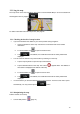
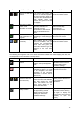
2.3.5 Using the Cursor (the selected map location)
First, place the Cursor at the desired map location with one of the following options:
x Use the Find menu to select a location. The map returns with the selected point (the Cursor) in
the middle, and the Cursor menu appears with the available options.
x Tap the screen to place the Cursor at the desired location. Now tap
to open the Cursor
menu.
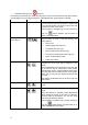
You can perform the following actions in Simple mode:
Button Action
Creates a new route with the Cursor as the destination. The previous route (if
exists) is deleted.
Saves the Cursor as a Favorite destination
Opens a screen with the name, address and coordinate information of the
Cursor, and the list of POIs near it
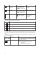
The following options are available in Advanced mode only:
Button Action
In the active route, uses the Cursor as the start point by replacing the current
GPS position (available in Advanced mode only)