
User`s manual


CompeGPS Team S.L.
http://www.compegps.com
http://support.compegps.com
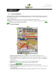
8. Compass: Shows the orientation of the device. The source of this datum may be set
(GPS, electronic compass or „automatic‟) from „menu > Settings > Off-road > Bearing‟.
7 Radar warnings / POIs
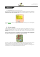
During your navigation, TwoNav may alert you when you get close to certain points of special
interest.
7.1.1 Radars
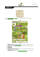
One special case of these types of points is the radars that control traffic speed.
TwoNav will consider the points introduced in the „TwoNavData\Radars‟ folder as radars and will
alert you with a sound and an image when you get close to one of them (see section Speed limit
to get to know the setting options of these warnings).
The system includes a radars data base from the AlerteGPS company that may be updated from
their web page, www.alerteGPS.com. In it you will find a section devoted to TwoNav products.
If you wish to update this information, all you have to do is substitute the original files by the
updated ones (in GPX, WPT or BWPT formats) into the „radars‟ folder kept in the
„TwoNavData\Radars‟ data folder.
7.1.2 POIs
You may also be alerted of other general interest points (POIs) that you may customize yourself.
TwoNav will load automatically the waypoints (in GPX, WPT or BWPT format) that you place
inside the „TwoNavData\POI‟ folder when starting up the system. These waypoints will not be
displayed in the waypoints list, but they will be drawn on the map.
You can hide these files on map from active personal POIs tool.
BWPT format is recommended, allowing a much quicker access to information. Files in other
formats can be converted to BWPT from CompeGPS Land PC software.
If you want to be alerted when reaching one of these POIs, each one of them will have to be
associated to a sound or image file, which will be reproduced when getting close to the point.
You may associate images or sounds in WAV format to the waypoints from the properties of the
waypoint window.
Warning: Using BWPT files with more than 5000 points may cause system slow down. GPX or
WPT files may cause such slow down even with much smaller files.
8 Data management (waypoints, routes, tracks and maps)
8.1 Waypoints
8.1.1 What is a waypoint?
The waypoint is a point defined by a geographical position, latitude and longitude coordinates and
in most cases altitude, used by the GPS navigation tools.
TwoNav lets you create, edit and navigate waypoints.