
User's Manual

Doc. No.
Rev.
Date
1.00
2011-12-08
Damm Cellular Systems A/S, Denmark
TETRAFLEX
®
V7.5 MANUAL - Dispatcher
TetraFlex® 7.5
Manual
3-90
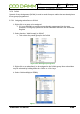
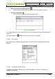
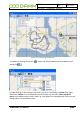
3.5.11 Map
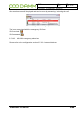
3.5.12 Detach Map
The map window may be detached from the main dispatcher window and placed anywhere
on the PC monitor(s)
This detachment is accomplished by selecting the detach/attach icon
positioned in the upper right hand corner of the map window. To attach again, select the
detach/attach icon once more
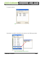
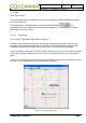
3.5.12.1 Positioning
The TetraFlex
®
dispatcher offers GPS positioning
Positions may be shown as a function of automatic positioning information send from the
terminals or as a manual request from the dispatcher. This functionality uses WG84 map
coordinates together with Google Maps or one of the other supported map formats.
It is also possible to add layers in ESRI Shapefile format on top of one of the supported maps
(except the standard Goggle map format) e.g..for showing details that are not on standard
maps.
Positions are shown as green circles and position history as yellow. When moving the mouse
over the circle, the data and time for the subscriber is shown.
Figure 3-76: Positioning Google