
User's Manual


Doc. No.
Rev.
Date
1.00
2011-12-08
Damm Cellular Systems A/S, Denmark
TETRAFLEX
®
V7.5 MANUAL - Dispatcher
TetraFlex® 7.5
Manual
3-91
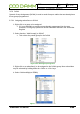
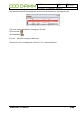
To request the position of a subscriber, right click on the phonebook entry and select the
option you want:
○ Select mobile on map - This highlights the GPS position of the radio on the map
with big green circle and subscriber details
○ Center on map – Center the GPS position on the map
○ Position History – Shows the Position History window and the historic GPS position
on the map as yellow circles
○ Request position – This request the actual GPS position from the radio. This could
be usefull when the radio has a long scan period for delivering GPS coordinates and
you want a position here and now.
○ Start Sepura Performance Reports – This function is at the moment only avaliable in
Sepura radios and is use for getting the RSSI downlink measurment from the radio.
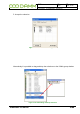
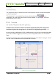
3.5.12.2 Configuring positioning
At present the TetraFlex
®
relies on the mobile to send positioning to a group.
Any group may be used, but it is recommended to create a specific positioning group. This
GPS to Group assignment must be set from the radio programming tool.
The position information SDS from the mobile is send to the group. The dispatcher is as rule
“member” of all groups, so the dispatcher will pick up the SDS information, process and show
it as a position on the map.
Positioning SDS’s are filtered out and will not be shown in the dispatcher SDS inbox
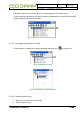
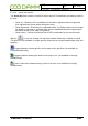
3.5.12.3 Overlay file in ESRI map (.shp) format
NOTE: The use of overlay files in ESRI format is dongle controlled.
You can use ESRI overlay maps on top Google premier maps, OpenStreet maps, Raster
maps and the Empty map option. Standard Google maps are not supported with overlay
maps. The Dispatcher uses a flag in the Dongle in order to enable and disable the ESRI
shape file view.
The current used overlay files are saved together with the used map and will be re-loaded
when the map view / dispatcher is started again.