
User Manual


©2012-2014 DJI. All Rights Reserved. - 16 -
(2)Altitude Offset Setting
GIS database (Google Earth™) is not precise, while Flight Path Mountain and other obstacle/building
collision checking feature performed based on this database, which is not real-time or up-to-date.
Google Earth™ plug-in is only for the purpose as a general landscape browser, for quick way points
positioning without much safety guarantee.
Pressure sensor is used for altitude sensing, leading the result varies according to weather. Therefore,
you might have different altitude values on the same location at different times. However, its relative
height may be far from precise than absolute altitude information in GIS.
Due to above problems, the following method for relative flight height calculation would be most reliable.
1) Record the aircraft altitude before take-off, as L
Gound
2) Way point altitude = Relative Flight Height + L
Gound
Please keep in mind that this method is the most reliable way for flight path collision precaution.
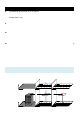
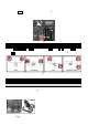
The Altitude Offset value given is only for the purpose to avoid visual confusion, such as Case 1 in fig.①
shown below. The aircraft represented by the red point was located on the ground in real world but
floating in the sky within 3D-Map. You have to give a negative offset value to reduce the aircraft altitude
for visual effect only. The calculate altitude offset function will give you a suggestion for offset setting but
not guaranteed to be correct. Because if the aircraft is landed on the roof of the building as in Case 2 in
figure shown below, and the building information will not appear in GIS database, which means you
cannot use the same method as in Case 1. You should calculate this offset value with a known or
estimated building height.
Tips:
We highly RECOMMEND you to consider the relative flight height discussed during flight mission editing.
Latitude
Altitude
Longitude
Latitude
Altitude
Longitude
IN REAL WORLD
IN 3D-MAP
Latitude
Altitude
Longitude
Latitude
Altitude
Longitude
Latitude
Altitude
Longitude
Latitude
Altitude
Longitude
Before set-offset
After set-offset
Case 1
Heli stay on the
ground
Case 2
Heli stay on the roof
of building