User's manual OnCourse Navigator | 4 User's manual OnCourse Navigator | 4 as on October 2004
Impressum Easy PocketNAV.com LLC. 6050 Peachtree PKWY STE 240-328 Norcross, GA 30092 The information contained herein may be changed at any time without prior notification. This manual nor any parts thereof may not be reproduced for any purpose whatsoever without the express written consent of Easy PocketNAV.com LLC, nor transmitted in any form either electronically or mechanically, including photocopying and recording. © Copyright 2004, Easy PocketNAV.com LLC All rights reserved.
User's manual OnCourse Navigator | 4 Table of contents 1 2 3 4 User's manual Introduction................................................................ 3 1.1 Important safety information ............................................. 4 1.1.1 Safety information on navigation ............................. 4 1.1.2 Safety information on the GPS receiver .................... 5 1.1.3 Safety information on the installation in the vehicle.... 5 1.2 Search facilities and conventions........................
User's manual OnCourse Navigator | 4 4.4.1 4.4.2 4.4.3 4.4.4 5 6 7 Displaying the route list ....................................... 63 Adding a stage point during navigation ................... 64 Blocking a route section ....................................... 65 Keeping the logbook ............................................ 66 Additional software: MapExport ................................ 69 5.1 Functionality of MapExport .............................................. 70 5.1.
User's manual OnCourse Navigator | 4 1 Introduction Topics covered in this chapter: 1.1 Important safety information page 4 Safety information on navigation Safety information on the GPS receiver Safety information on the installation in the vehicle 1.2 Search facilities and conventions page 6 1.3 Liability page 6 Support 1.
User's manual OnCourse Navigator | 4 1.1 Important safety information Note 1.1.1 In your own interest, read the following notices and safety information carefully before starting up your navigation system. Safety information on navigation The use of OnCourse Navigator may only be effected at your own risk.
User's manual OnCourse Navigator | 4 1.1.2 Safety information on the GPS receiver Attention: As it is not waterproof, do not expose your GPS receiver to water! Attention: Do not install the cable next to security relevant equipment and supply lines. Attention: Please check the security relevant equipment when you have installed the navigation system. Attention: The GPS receiver should be disconnected from the power supply while your car is parking.
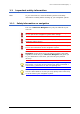
User's manual OnCourse Navigator | 4 1.2 Search facilities and conventions Find information quickly This manual offers the following search facilities: Ù In the footnote at the bottom of the page, you may check which chapter and which section you are actually reading. Ù A glossary at the end of the manual contains explanations on the technical terms used in this manual. Ù An index at the end of the manual allows precise search for the information contained in this manual.
User's manual OnCourse Navigator | 4 1.3.1 Support You need help? Send an email to support@OnCourseNavigator.com You may also find further information on the web site of Easy PocketNAV.com LLC (www.OnCourseNavigator.com). 1.4 Trademarks Registered trademarks All brands and trademarks mentioned in this document are possibly registered by third party and subject to the current legislation and to the rights of their respective owners without reservation.
User's manual OnCourse Navigator | 4 2 Installation and quick-start guide Topics covered in this chapter: 2.1 Operating mode of your navigation system page 10 Hardware components at large 2.
User's manual OnCourse Navigator | 4 2.1 Operating mode of your navigation system OnCourse Navigator The time of complicated and frustrating inquiries on the right way in folded maps is over. From now on OnCourse Navigator, your navigation system, will guide you, based on satellite information, quickly and safely to your destination. Scope of services With OnCourse Navigator you will not only arrive quickly and safely at your destination.
User's manual OnCourse Navigator | 4 Operating mode of your navigation system The so-called base map (e.g. of USA and Canada) and a software designed for exporting extracts of this base map are installed on your PC (if you have purchased the version with 4 CD-ROMs). Via ActiveSync you may transmit areas of the base map to your Pocket PC. Itinerary planning may be done as well on your PC as on your Pocket PC.
User's manual OnCourse Navigator | 4 2.2 Installation of the navigation system Quick-start guide… Depending on the version you have purchased, you must carry out the following procedures before using OnCourse Navigator: Case A: 4 CD-ROMs Case A: You have purchased 4 CD-ROMs. Proceed as follows: You need a PC for installation. All software components necessary for navigation will be installed on your Pocket PC.
User's manual OnCourse Navigator | 4 2.2.1 Software installation on your PC and on your Pocket PC (Case A) Survey You must install the software on your PC and on your Pocket PC before you can use your navigation system. At the beginning of the installation process, the base map (e.g. of USA and Canada) and the MapExport software (which is designed for defining and exporting your own areas of the base map and for transferring them to your Pocket PC) will be installed on your PC.
User's manual OnCourse Navigator | 4 2.2.2 Software installation on your Pocket PC (Case B) Survey The OnCourse Navigator navigation software will be installed on your Pocket PC. Installing the software... 1. Insert the storage card into your Pocket PC. 2. Turn on your Pocket PC. 3. Open the File Explorer via Start > Programs. 4. Open the directory of your storage card. 5. Start the installation program OnCourse Navigator 4.cab The installation of OnCourse Navigator begins. 2.2.
User's manual OnCourse Navigator | 4 You want to... so... select an already exported map, click the Map archive icon define a rectangular segment, click the Area icon define a map corridor by determining the stages of an itinerary, click the Corridor icon The software calculates the data and indicates the storage capacity required by the defined segment. Notice: The size of the defined segment must not exceed the available storage capacity on your Pocket PC. 3.
User's manual OnCourse Navigator | 4 2.2.5 Installation in the vehicle Survey Mount the holder of the Pocket PC and the GPS receiver before you use the navigation system. You will also have to initialize the GPS receiver. Notice: The holder and the adapter of the Pocket PC are not supplied within the delivery. Mounting and connecting the Pocket PC Attention: The mounted holder must not impede the driver’s attention on the traffic.
User's manual OnCourse Navigator | 4 Mounting and connecting the GPS receiver Attention: The mounted GPS receiver must not impede the driver’s attention on traffic. Connecting the GPS receiver... 1. Place the GPS receiver horizontally under the windscreen, as far forwards as possible. Notice: The reception of GPS-signals may be obstructed by windscreen heating wires, by a windscreen aerial, or when the windscreen is metallized.
User's manual OnCourse Navigator | 4 5. Start OnCourse Navigator. 6. On the main screen, tap the Settings button. The SETTINGS screen opens. 7. Via the arrow buttons, select GPS. 8. Tap the Type of receiver field and indicate the type of your GPS receiver. You have… then… the standard GPS receiver, select standard GPS. the MIO 168 Pocket PC with builtin GPS receiver select MIO 168. a GPS receiver of another brand, select Other receiver. 9. Tap the Com-Port field and indicate the COM-port.
User's manual OnCourse Navigator | 4 Initializing the GPS receiver Initialization of the GPS receiver The initialization process of the GPS receiver starts automatically. Within 15 seconds the color of the GPS icon in OnCourse Navigator changes from red (No GPS signal) to orange (GPS signals insufficient). The number on the GPS icon indicates the number of satellites from which signals are being received.
User's manual OnCourse Navigator | 4 2.2.6 Starting navigation Use your navigation system… 1. Turn on your Pocket PC. 2. Start OnCourse Navigator by tapping OnCourse Navigator 4. > Programs > 3. Tap the One destination button to enter your destination. The DESTINATION screen opens: 4. Tap the Region entry field and select the destination state or territory/province. 5. Tap the Address button.
User's manual OnCourse Navigator | 4 The ADDRESS screen opens: 6. Enter the name of the destination town into the City field. 7. Enter the name of the destination street into the Street field. Enter the house number if possible. Notice: You do not need to enter a street suffix, or a street type to get a search result. For example, if you are looking for a street called "S Main Avenue", simply type in "main". 8. Tap the Start navigation button.
User's manual OnCourse Navigator | 4 3 Operating the navigation software Topics covered in this chapter: 3.1 Starting OnCourse Navigator page 24 Basic settings 3.2 User interface and basic functionality page 27 Icons 3.3 Indicating destinations page 30 Entering a destination manually Selecting a Selecting destinations from the Outlook contacts list Indicating destinations on the map Saved destinations Recent destinations Save and use your home address Voice command 3.
User's manual OnCourse Navigator | 4 3.1 Starting OnCourse Navigator Precondition You have carried out installation and activation of OnCourse Navigator as described in “Installation of the navigation system”, page 12. Starting the navigation software… 1. Turn on your Pocket PC. 2. Start OnCourse Navigator by tapping OnCourse Navigator 4. > Programs > The Main screen opens: Main screen All functions of the program are accessible via the Main screen.
User's manual OnCourse Navigator | 4 Tap this button for itinerary planning purposes. For details, please refer to “Navigating to several destinations (Itinerary planning)”, page 59. Tap this button to display the map currently in use. Tap this button to select another map which is stored on your Pocket PC. Notice: You cannot profit from this function unless you have installed MapExport on your PC. For details, please refer to “Working with the map”, page 45.
User's manual OnCourse Navigator | 4 Saving your home address In OnCourse Navigator, you may save your home address to quickly start navigation homewards from anywhere. 1. On the main screen, tap Settings. The SETTINGS screen opens. 2. Via the arrow buttons, select the HOME ADDRESS screen. 3. Tap Enter your home address. The DESTINATION screen opens. 4. Tap the Address button and enter your home address as described in “Entering a destination manually”, page 31. 5. Tap the Set as home address button.
User's manual OnCourse Navigator | 4 3.2 User interface and basic functionality Operation In order to offer a maximum of flexibility and convenience for the operation of OnCourse Navigator there is three ways to make entries: Ù tapping with the stylus, Ù tapping with your finger, or Ù via the hardware keys of your Pocket PC. Moreover, you may indicate a saved destination by voice to start navigation to it. 3.2.
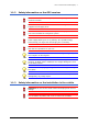
User's manual OnCourse Navigator | 4 GPS The color of this icon and the number displayed on it have the following significance: Color/Number Significance red A GPS receiver is not connected or the power supply is interrupted. orange + number of received satellites A GPS receiver is connected, but the received signals are not convenient for navigation purposes (e.g. because you are in a closed building). green + number of received satellites The signals are convenient. Navigation may begin.
User's manual OnCourse Navigator | 4 Entry Significance Speed Indicates your current speed. Position Indicates the address of your current position. Save current position Tap this button to add the current address to the saved destinations list. Close window Tap this button to quit the GPS screen. Start Tap this icon to start another program on your Pocket PC without quitting OnCourse Navigator. This may be useful if, e.g.
User's manual OnCourse Navigator | 4 3.3 Indicating destinations Basic principle of navigation The indication of destinations is the basis of navigation respectively of itinerary planning. In this chapter, you will learn about the possibilities to indicate and manage destinations in OnCourse Navigator. For details on destination management, please refer to “Navigation and Itinerary planning”, page 55.
User's manual OnCourse Navigator | 4 3.3.1 Entering a destination manually Database of places The data of all places covered by the currently loaded map is stored in the database of places. You need not enter the complete names of towns and streets as OnCourse Navigator lists automatically all names that match with your entry. If you enter for example "ri" into the City entry field and tap the Ok button you will obtain a list of all towns beginning with "ri" or having "ri" into their names.
User's manual OnCourse Navigator | 4 Indicating a destination… 1. On the main screen tap One destination. The DESTINATION screen opens. 2. Tap the Region entry field and select the destination state or province/territory. 3. Tap the Address entry field. The ADDRESS screen opens: 4. Enter the name of the destination town into the City entry field. For cities in the United States you may also enter the postal code. 5. Enter the destination street into the Street entry field.
User's manual OnCourse Navigator | 4 3.3.2 Selecting a Point of Interest Points of Interest Points of Interest are stored in the database of places and may be displayed on the map. Ports, airports, restaurants, hotels, petrol stations, public buildings, and others belong to the Points of Interest. Indicate a Points of Interest by selecting one Ù on the map, see “Indicating destinations on the map”, page 39, Ù nearby, Ù of superregional interest, or Ù in another town. Selecting a Point of Interest...
User's manual OnCourse Navigator | 4 Points of Interest nearby Notice: You may only display Points of Interest nearby when the GPS receiver is connected and when your current position can be determined. Selecting a Point of Interest nearby... 2. On the POINT OF INTEREST screen, tap the Nearby button. The POINT OF INTEREST NEARBY screen opens: 3. Enter the radius around your current position within which you want to search for Points of Interest into the Radius entry field. 4.
User's manual OnCourse Navigator | 4 Points of Interest of superregional interest Selecting a Point of Interest of superregional interest... 8. On the POINT OF INTEREST screen, tap the Of superregional significance button. The POINT OF INTEREST OF SUPERREGIONAL SIGNIFICANCE screen opens: 9. Select the main category of Points of Interest to search for from the Category list field, e.g. "Airports". 10. Select the correct destination from the Point of Interest list field. 11.
User's manual OnCourse Navigator | 4 Point of Interest in another town Selecting a Point of Interest in another town... 2. On the POINT OF INTEREST screen, tap the In another city button. The POINT OF INTEREST IN ANOTHER CITY screen opens: 3. Enter the name of the city in which you want to search for Points of Interest into the City field. 4. Select the main category of Points of Interest to search for from the left one of the two Category list fields, e.g. “Nightlife”.
User's manual OnCourse Navigator | 4 3.3.3 Selecting destinations from the Outlook contacts list Using Outlook contacts as destination… Any address from the Outlook contacts list on your Pocket PC may be used as destination for navigation or itinerary planning purposes. In order to identify an address clearly and without ambiguity, town, postcode, street, and house number should be indicated.
User's manual OnCourse Navigator | 4 3a The following screen opens when there was more than one address to be found for the respective contact: 3b Tap the OK button, which belongs to the address you want to use as destination. OnCourse Navigator adopts the address. 4. Tap the Save button if you want to navigate more often to this contact. You may then quickly select the address from the Saved destinations list.
User's manual OnCourse Navigator | 4 3.3.4 Indicating destinations on the map You may indicate a destination directly on the map. In addition to towns and streets, you may also select Point of Interest quickly.. Indicating a destination on the map... 1. On the main screen tap One destination. The DESTINATION screen opens. 2. Tap the Select on map button. The map screen opens: 3. Tap on the place you want to determine as destination and hold.
User's manual OnCourse Navigator | 4 Database information on the respective place will be loaded and displayed: 4. Tap the Task field. The TASK screen opens where you may indicate how to proceed: 5. Select Start navigation from the list to navigate to the respective place. Tap the Save button if you want to navigate more often to the entered destination. You may then quickly select it from the Saved destinations list.
User's manual OnCourse Navigator | 4 3.3.5 Saved destinations Saved destinations All destinations you have saved by tapping the Save button are listed on the SAVED DESTINATIONS screen. On this screen you may: Ù select destinations for navigation purposes, Ù rename destinations, and Ù delete destinations from the list. Take over 1. On the main screen tap One destination. The DESTINATION screen opens. 2. Tap the Saved destinations button. 3. Tap the entry of the respective destination.
User's manual OnCourse Navigator | 4 Deleting a destination 1. Tap the entry of the destination to be deleted. 2. Tap the Delete icon. The destination is now deleted. 3.3.6 Recent destinations Recent destinations All destinations you have navigated to recently are listed on the RECENT DESTINATIONS screen. On this screen you may: Ù Select destinations for navigation purposes, Ù Add destinations to the SAVED DESTINATIONS list, and Ù Delete destinations from the list. Taking over 1.
User's manual OnCourse Navigator | 4 3.3.7 Save and use your home address Survey You may store your home address in OnCourse Navigator in order to quickly start navigation home at any place. Saving your home address… 1. On the main screen, tap the Settings button. The SETTINGS screen opens. 2. Via the "Left" and "Right" icons, select Home address. 3. Tap the Enter your home address button. The DESTINATION screen opens. 4.
User's manual OnCourse Navigator | 4 3.3.8 Voice command Survey You may store a voice command with any saved destination. You may then start navigation to this destination by speech. Storing a voice command... 1. Open the SAVED DESTINATIONS screen and select the destination for which you want to store a voice command. 2. Tap the Rename icon . The NAME OF DESTINATION dialog box opens. 3. Tap Voice recording. The following message appears: 4. Pronounce the name of the destination (into the Pocket PC).
User's manual OnCourse Navigator | 4 3.4 Working with the map Survey There are various pieces of information available on the MAP screen. Learn in this chapter about the possibilities for working with the map, which depend on whether you are in navigation mode, or not. If you have not purchased a map on a memory card, you have to transmit one or more maps from your PC to your Pocket PC using the MapExport software before you can display a map or start navigation.
User's manual OnCourse Navigator | 4 3.4.1 Operating the map Displaying the map You may display the map Ù while planning an itinerary, Ù in order to show destinations on the map, or Ù in order to select destinations on the map. You may display the map via the Show map button on the main screen or via the Show on map and Select on map buttons, which are available when you indicate a destination. The map is being displayed automatically when you are navigating.
User's manual OnCourse Navigator | 4 Icons The following icons are displayed on the map: Zoom / Scroll Tap the Scroll icon to switch between Zoom and Scroll mode. Zoom In Zoom mode (the icon appears white) you may scale the map up or down. Zoom in by drawing a rectangle on the map, beginning with the upper left corner. Zoom out by beginning with the lower right corner. Scrolling In Scroll mode (the icon appears red) you may scroll the map. Tap on the screen and drag to the desired direction.
User's manual OnCourse Navigator | 4 Zoom out Tap Zoom out to scale the map up. Additional functions Tap the Additional functions icon to display the ADDITIONAL screen. The availability of some functions depends on whether you are being in navigation mode or not. FUNCTIONS The ADDITIONAL FUNCTIONS screen opens: Tap the Day icon to adapt the luminosity of the screen to daylight conditions. Tap the Night icon to adapt the luminosity of the screen to night conditions.
User's manual OnCourse Navigator | 4 Change preferences Tap Change preferences to display the SETTINGS screen. For details, please refer to “Annex A: Configuration of OnCourse Navigator”, page 102. Quit navigation This function is only available in navigation mode. Tap Quit navigation to exit navigation mode. Block road, Unblock, New block These functions are only available in navigation mode. For details, please refer to “Blocking a route section”, page 65.
User's manual OnCourse Navigator | 4 3.4.
User's manual OnCourse Navigator | 4 Information on the itinerary At the right of the map, the following information on the itinerary is being displayed: Field Information This symbol means "stage". All information displayed below refers to the next stage point. ETA (Estimated time of arrival). Remaining time to arrival (estimated). Remaining distance to arrival (estimated). Tap this icon to repeat the last spoken instruction. All available information will be displayed.
User's manual OnCourse Navigator | 4 3.4.3 Displaying additional information on the map In OnCourse Navigator you may determine which information is to be displayed on the map. Modifying any configuration begins on the SETTINGS screen. Configuring the display of additional information… 1. On the main screen, tap Settings or icon on the map and select Change tap the preferences. The SETTINGS screen opens. 2. Select Map information using the arrow buttons: Info bar 3.
User's manual OnCourse Navigator | 4 7. Tap the command buttons to display (On) or not (Off) the respective information on the map. The desired information on the entire itinerary (upper section) and on the current stage (lower section) will be displayed at the right hand side of the map. Section Information This symbol means "itinerary". All information displayed below refers to the final destination. This section is only available if you have indicated more than one destination to navigate to.
User's manual OnCourse Navigator | 4 4 Navigation and Itinerary planning Topics covered in this chapter: 4.1 General notes on navigation page 56 4.2 Navigating to a destination page 57 4.3 Navigating to several destinations (Itinerary planning) page 59 Working on itineraries, storage and management 4.
User's manual OnCourse Navigator | 4 4.1 General notes on navigation The use of OnCourse Navigator may only be effected at your own risk. Attention: To protect yourself and others from accidents please do not operate the navigation system while driving! Attention: You must not look at the display except when it is absolutely safe to do so! Attention: The road layout and the traffic signs are absolutely prior to the instructions of the navigation system.
User's manual OnCourse Navigator | 4 4.2 Navigating to a destination Navigating to a destination… 1. Enter your destination as described in “Indicating destinations”, page 30. 2. Tap the Start navigation button. The ROUTE OPTIONS screen opens: 3. Tap the TYPE OF ROUTING field and select one of the following options: Option Signification Fast route The quickest route will be calculated. Short route The shortest route will be calculated. Pedestrian route A route for pedestrians will be calculated.
User's manual OnCourse Navigator | 4 4. Tap the Interstates, Ferries, and Tollways fields successively and select one of the following options: Option Signification Permitted The respective kind of street will be regarded for route calculation. Avoid The respective kind of street will be avoided if reasonable. Forbidden The respective kind of street will be disregarded for route calculation. Notice: The Route options settings will be saved.
User's manual OnCourse Navigator | 4 4.3 Navigating to several destinations (Itinerary planning) Itinerary planning You may plan itineraries without receiving GPS-signals, e.g. comfortably at home. Planned itineraries may be stored. Thus you may plan as many itineraries as you want, e.g. for holidays. Navigating to several destinations… 1. On the main screen, tap Several destinations. The ITINERARY screen opens: 2. Tap the Add destination icon to indicate the first stage point.
User's manual OnCourse Navigator | 4 6. Tap the entry of the stage point you want to navigate to first. Notice: You have to select the stage point you want to navigate to first. You may then continuer navigation when it was interrupted. You may as well navigate to only some of the stage points of a stored itinerary. 7. Tap Start navigation. The route is now being calculated. The map is being displayed in navigation mode.
User's manual OnCourse Navigator | 4 4.3.1 Working on itineraries, storage and management Survey You may plan as much itineraries as you want, e.g. for holidays. You may save them and use them later for navigation purposes. At any moment, you may add stage points, modify the order of the stages, or display the itinerary on the map. The following commands are available: One place up Tap the One place up icon to navigate to the respective stage point earlier (example: stage 3 becomes stage 2).
User's manual OnCourse Navigator | 4 Tap Show on map to display the entire itinerary on the map. The route will be highlighted in green: 4.3.2 Simulating the route Simulation You may execute a simulated navigation along the itinerary when the route has been calculated. Notice: The reception of GPS-signals is not necessary for the simulation. Simulating the route… 1. Tap the Show on map icon. The itinerary is displayed on the map. 2. Tap the Additional functions icon. 3. Tap Start simulation.
User's manual OnCourse Navigator | 4 4.4 Functions which are useful for navigation Survey In OnCourse Navigator the following functions are available in navigation mode: Ù Adding a stage point during navigation, see page 64. Ù Blocking route sections, see page 65. Ù Keeping the logbook, see page 66. 4.4.
User's manual OnCourse Navigator | 4 4.4.2 Adding a stage point during navigation Adding a stage point during navigation… At any moment during navigation you may add a new stage point to your itinerary. The route will be recalculated in order to make the new stage point the next destination to navigate to. The other remaining stage points will be navigated to after the new one. Adding a stage point… Precondition: The map is being displayed in navigation mode. 1. Tap the Additional functions icon. 2.
User's manual OnCourse Navigator | 4 4.4.3 Blocking a route section Blocking a route section manually You may block a route section manually in order to evade it. Manual blocking forces a recalculation of the route. Presume that you are driving on an interstate and a radio message announces a traffic jam of 4 miles near your current position. With the “Block route sections” function you may instruct the navigation system to evade the announced traffic jam.
User's manual OnCourse Navigator | 4 4.4.4 Keeping the logbook Survey You may make OnCourse Navigator keep a logbook. Any start of the logbook forces the creation of an Excel file in the root directory of your Pocket PC. You may transmit this file to your PC and open it with, e.g., Microsoft Excel. Starting the logbook… 1. Tap the Logbook icon . The LOGBOOK screen opens: 2. Enter the reason of your journey into the Comment field. 3.
User's manual OnCourse Navigator | 4 Working with the logbook… You may transmit the logbook file to your PC where you may open it and modify the entries (if necessary). 1. Establish an ActiveSync connection between your PC and your Pocket PC. (For details refer to the manual or your Pocket PC) 2. In the root directory of your Pocket PC select the logbook file named "Logbook.xls". 3. Copy the file to your PC and open them with Microsoft Excel.
User's manual OnCourse Navigator | 4 5 Additional software: MapExport Topics covered in this chapter: 5.1 Functionality of MapExport page 70 Map export and transfer Transfer of Standard map extracts 5.2 User’s interface and basic functionality page 71 Starting MapExport Operating elements Hot keys Structure of the windows 5.3 Working with maps page 76 Loading and displaying maps Icons 5.4 Exporting segments of the map page 80 Corridor surrounding an itinerary Area 5.
User's manual OnCourse Navigator | 4 5.1 5.1.1 Functionality of MapExport Map export and transfer Notice: You do not dispose of MapExport unless you have purchased the 4-CD-version of OnCourse Navigator and installed the software. Survey The transfer of maps is divided into two independent steps: Ù Map export: The generation of determined map segments and their storage on the hard disk of your PC. For details, please refer to “Corridor surrounding an itinerary”, page 80 and to “Area”, page 89.
User's manual OnCourse Navigator | 4 5.2 5.2.1 User’s interface and basic functionality Starting MapExport Starting MapExport… 1. Start MapExport on your PC by clicking Start > Programs > OnCourse Navigator 4 > MapExport. The MAIN MENU opens: Main menu Via the MAIN MENU you may access all functions of the software. Click the Map archive icon to transmit provided or self-exported map segments to your Pocket PC or to a memory card.
User's manual OnCourse Navigator | 4 Standard directory for the basic map Click the Select button on the “Basic map” section to determine another folder for the base map. For details, please refer to “Base map”, page 76. Standard directory customized maps Click the Select button on the Customized maps section to determine another folder for maps you have exported yourself. For details, please refer to “Customized maps”, page 76. Click Quit to quit MapExport.
User's manual OnCourse Navigator | 4 5.2.2 Survey Operating elements The operating elements of MapExport are listed below: Element Function Entry field Make entries into entry fields. List field Select between the entries listed in a list field. Command button Click a command button to execute an action, e.g. renaming a map. Combo box A combo box is a combination of both entry field and list field. Make an entry or select one of the listed entries.
User's manual OnCourse Navigator | 4 5.2.3 Survey Hot keys The hot keys which enable MapExport operation without mouse are listed below: Key Function [TAB] Focuses the next field or button Focuses the next menu item. [SHIFT] + [TAB] Focuses the previous field or button Focuses the previous menu item. Arrow keys [UP] – Selects the previous list item or focuses the previous radio button of an option group. [DOWN] – Selects the next list item or focuses the next radio button of an option group.
User's manual OnCourse Navigator | 4 5.2.4 Structure of the windows Main menu Use and structure Ù Via the MAIN MENU you may access all functions of the software. Ù The paths of the standard directories for the basic map and for Customized maps are indicated and may be modified. Corridor, Area, Map archive Corridor, Area, Map archive These windows consist of two sections: a map section al the left and a functional section at the right. Open these windows via the MAIN MENU.
User's manual OnCourse Navigator | 4 5.3 5.3.1 Working with maps Loading and displaying maps Base map Survey During the installation process the Base map has been stored on your PC’s hard disk. The path to the folder containing the Base map is indicated in the Base map field of the MAIN MENU and may be modified there. This map is the base for exporting map segments. It is displayed in the Map section of the AREA and CORRIDOR windows. Transferring the Base map to another folder of your hard disk… 1.
User's manual OnCourse Navigator | 4 Standard folder for customized maps A standard folder for customized maps has been created during the installation process. All customized maps you have exported (areas and corridors) are stored therein. Modifying the path to the standard folder for Customized maps… 1. In the WINDOWS EXPLORER, create a new folder for Customized maps. 2. In the MAIN MENU of MapExport, click the Select command at the right of the Customized maps field.
User's manual OnCourse Navigator | 4 5.3.2 Survey Icons At the upper right corner of the map, there are icons to scroll the map, to determine the scale of the map, and to define segments of the map in order to export them. Depending on which window is active, some icons may be deactivated (for example the segment definition icons on the MAP ARCHIVE window). Scrolling the map: 1. Click the Scroll map icon. The mouse pointer becomes a hand. 2.
User's manual OnCourse Navigator | 4 Adding a stage point: The Stage point icon is only activated on the CORRIDOR window. Click this icon to add a stage point by clicking it on the map. For details, please refer to “Corridor surrounding an itinerary”, page 80. Defining an area: The Draw area icon is activated only on the AREA window. Click this icon to define a rectangular area which may be exported. For details, please refer to “Area”, page 89.
User's manual OnCourse Navigator | 4 5.4 Exporting segments of the map 5.4.1 Corridor surrounding an itinerary Survey You may cut a corridor of the base map and export it. The definition is done by selecting stage points of an itinerary and by indicating the width of the corridor and the radius round the stage points. The stage points will be exported with the map.
User's manual OnCourse Navigator | 4 Defining the stage points of an itinerary Survey Any town, street, or Point of Interest covered by the base map may be selected as stage point. To determine a stage point, you may Ù enter it by keyboard or Ù click it on the map. Adding stage points… 1. Click the Search icon. The SEARCH FOR PLACE OR POINT OF INTEREST dialog window opens. 2. Click the Country combo box and select the destination country.
User's manual OnCourse Navigator | 4 7. Enter a house number into the No. field at the right hand side if possible or enter the name of crossroad into the Intersection entry field. 8. Click the Set route points button to determine the entered address as stage point. The address will be added to the list of stage points. On the map, a small flag will indicate the stage point with the number of its position on the itinerary. 9. Repeat steps 2 to 6 for each address you want to add to the list of stage points.
User's manual OnCourse Navigator | 4 Selecting a stage point on the map… 1. On the map, search for the place or Point of Interest you want to set as stage point. 2. Click the Stage point icon. The mouse pointer becomes an arrow with a small flag. 3. Click the desired place (or Point of Interest) to add it to the list of stage points. The address (or Point of Interest) will be added to the list of stage points.
User's manual OnCourse Navigator | 4 Defining the route options Defining the route options… 1. Click the Route options button. The ROUTE OPTIONS dialog window opens: Route options Speed profile 2. Select one of the following options from the upper section: Option Signification Quick route The quickest route will be calculated. Short route The shortest route will be calculated. Pedestrian route A route for pedestrians will be calculated.
User's manual OnCourse Navigator | 4 Checking, displaying and exporting itineraries Survey You may plan as much itineraries as you want, e.g. for holidays, in order to use them later for navigation purposes. At any moment, you may add stage points, change their order or display an itinerary on the map. The following commands are available: One place up Click the One place up icon to navigate to the respective stage point earlier (example: stage 3 becomes stage 2).
User's manual OnCourse Navigator | 4 Route information When the route has been calculated, the following information is being displayed on the functional section: Ù In the Duration column, the distance and the estimated duration to the next stage point are being indicated. Ù In the Total field, the total distance and the total duration are being indicated. Ù In the Information on the selected corridor section, the amount of required memory is being indicated.
User's manual OnCourse Navigator | 4 Loading the stage points of a saved itinerary… Click From PC to load the stage points of an itinerary which is saved on the hard disc of your PC. Click From Pocket PC to load the stage points of an itinerary which is saved on your Pocket PC. The stage points will be added to the list of stage points and may be modified. Saving the itinerary… Click To PC to save the itinerary to the hard disc of your PC. Click To Pocket PC to save the itinerary to your Pocket PC.
User's manual OnCourse Navigator | 4 Exporting the corridor Survey Having entered stage points, radius and corridor width, you may initiate the exportation of the corridor to the hard disc of your PC. The new map may be transferred to the Pocket PC instantly after exportation or at a later moment. Entering the name of the map… 1. Enter the name of the new map into the respective entry field: Starting exportation… 2. Click the Create map button. Exportation of the map begins.
User's manual OnCourse Navigator | 4 5.4.2 Area Survey You may cut a rectangle of the base map and export it. The map segment may be exported to the hard disc and may then be transferred to your Pocket PC. Looking for Hawaii…? Hawaii is not covered by the base map. The delivery of OnCourse Navigator includes, however, an already exported map section of Hawaii, which you may directly transfer to your Pocket PC. 1. To transmit the map of Hawaii, click the Hawaii button. The MAP ARCHIVE window opens. 2.
User's manual OnCourse Navigator | 4 If the area is to cover certain places or Points of Interest, you may search for them in the database of places. Click the Search icon. For details, please refer to “Defining the stage points of an itinerary”, page 81. 2. Click the Draw Area icon. 3. On the map, click one corner of the rectangle to define, keep the left mouse button pressed and draw the desired rectangle. The determined rectangle is highlighted by black hatching.
User's manual OnCourse Navigator | 4 All concerned countries and/or states or provinces/territories are selected (highlighted in blue). In order to deselect a country or state or province/territory, click on its entry. Only the cartographic data of those regions, which are within the rectangle and within the selected (highlighted in blue) countries and/or states or provinces/territories will be exported. This may be useful to minimize the memory requirements of an exported area.
User's manual OnCourse Navigator | 4 Shifting the area… 1. Point at the middle of the area. 2. Keep the left mouse button pressed and draw the rectangle to the desired position. Exporting the area Survey Having made all necessary indications, you may initiate the exportation of the area to the hard disc of your PC. The new map may be transferred to the Pocket PC instantly after exportation or at a later moment. Entering the name of the map… 1.
User's manual OnCourse Navigator | 4 5.5 Transferring segments of the base map Opening the Archive window… 1. On the MAIN MENU, click the Map archive icon. The MAP ARCHIVE window opens. On the functional sector, there are two list fields: Ù The first list contains all customized maps which are stored in the standard folder for Customized maps on the hard disk of your PC. Ù The second list contains Standard maps (exported segments of the base map included in the delivery).
User's manual OnCourse Navigator | 4 Deleting a map… 1. On the Customized maps list field, click the entry of the map to be deleted. 2. Click the Delete command button. 3. Confirm by clicking Yes. The map and its entry on the Customized maps list field are deleted. Transferring maps… There is two ways to transmit a map: Ù Via an ActiveSync connection. Ù Via a card reader to a memory card. 1. To transmit a Standard map, insert the respective CD-ROM into your CD-drive.
User's manual OnCourse Navigator | 4 Transfer via a card reader 1. Connect the card reader to your PC and insert the memory card. 2. To transmit a Standard map, insert the respective CD-ROM into your CD-drive. 3. Select the map to transmit from either the Customized maps list field or the Standard maps list field. The selected map is displayed on the map sector. 4. Click the Via card reader command button. The BROWSE FOR FOLDER dialogue window opens. The size of memory requested by the map is indicated.
User's manual OnCourse Navigator | 4 6 Additional software: SkinEditor Topics covered in this chapter: 6.1 Skin creation page 98 6.2 Selecting a Skin in OnCourse Navigator page.
User's manual OnCourse Navigator | 4 6.1 Skin creation Notice: You do not dispose of SkinEditor unless you have purchased the 4-CD-version of OnCourse Navigator and installed the software. Survey With SkinEditor, you may personalize the user interface of OnCourse Navigator. You may determine the colors of the screen elements and the background of the screens. Any modification will instantly be displayed on the example screens at the right hand side of the SKINEDITOR window. Personalizing... 1.
User's manual OnCourse Navigator | 4 6.2 Selecting a Skin in OnCourse Navigator Selecting a Skin in OnCourse Navigator… 5. Start OnCourse Navigator on your Pocket PC. 6. Tap the Settings button. 7. Select the REPRESENTATION screen and tap the Skin field. 8. Select one of the available skins and tap OK. 9. Tap the Save button to load this skin at the next starts of OnCourse Navigator.
User's manual OnCourse Navigator | 4 Additional software: SkinEditor - 100 -
User's manual OnCourse Navigator | 4 7 Appendix Topics covered in this chapter: 7.1 Annex A: Configuration of OnCourse Navigator page 102 Map information Route information Volume Representation Auto mode Speed profile Logbook Keypad Itinerary Format GPS Home address 7.
User's manual OnCourse Navigator | 4 7.1 Annex A: Configuration of OnCourse Navigator Configuration In OnCourse Navigator, you may modify the following settings: Ù Map information, see below. Ù Route information, see page 103. Ù Volume, see page 103. Ù Representation, see page 104. Ù Auto mode, see page 104. Ù Speed profile, see page 104. Ù Logbook, see page 105. Ù Keypad, see page 105. Ù Itinerary, see page 105. Ù Format, see page 105. Ù GPS, see page 106. Ù Home address, see page 106.
User's manual OnCourse Navigator | 4 7.1.2 Route information Route information On the ROUTE INFORMATION screen, you may effect the following modifications: Element Signification Dist. to final dest. Remaining distance to the final destination (estimated) Remaining time to the final destination (estimated). ETA (Estimated time of arrival) at the final destination. Tap the respective command buttons to display (Yes) or not (No) the respective information on the map.
User's manual OnCourse Navigator | 4 7.1.4 Representation Representation 7.1.5 Element Signification Skin Skins are made to personalize the user interface of OnCourse Navigator. Tap the Skin field. Select one of the available skins and tap OK. For details, please refer to “Skin creation”, page 98. Shade at night Tap this field and select whether the screen or your Pocket PC is to be darkened at night or not. Auto mode Auto mode 7.1.
User's manual OnCourse Navigator | 4 7.1.7 Logbook Logbook On the LOGBOOK screen, determine whether the logbook is to be started automatically at the beginning of navigation (Yes) or not (No). Tap the Start automatically on available GPS signal button to toggle between Yes and No. Independent from the settings made here, you may at any time start or stop the logbook via the icon. 7.1.
User's manual OnCourse Navigator | 4 7.1.11 GPS GPS On the GPS screen, configure the GPS receiver. Element Signification Type of receiver Tap the Type of receiver field. Select the appropriate receiver from the list and tap OK. Com-Port Tap the Com-Port field and indicate the COM / USB-port used by the receiver. Baud If you are using a GPS receiver of another brand (Type: Other receiver), enter the respective Baud rate into the Baud field. 7.1.
User's manual OnCourse Navigator | 4 7.2 Annex B: Problem solutions 7.2.1 Installation Installation failed Software installation on your Pocket PC has failed. 1. Uninstall the software by clicking Start > Programs > OnCourse Navigator 4 > De-installation on your PC. 2. Reinstall Microsoft ActiveSync on your PC. 3. Reinstall the software. 7.2.2 Performance Slow calculation Route calculation is very slow; the voice indications in navigation mode are coming late.
User's manual OnCourse Navigator | 4 7.2.3 GPS receiver Possible error sources concerning the initialization of the GPS receiver If the GPS symbol stays red (no GPS-reception) even though the system has been installed correctly, this may be due to one of the following reasons: Ù Reason A: an incorrect COM-port is selected. Ù Reason B: the receiver is not supplied with power. A The GPS receiver is connected to another COM-port than COM 1. 1. On the main screen, tap the Settings button.
User's manual OnCourse Navigator | 4 8 Glossary COM-port A COM port is a connector to a communications interface, usually the serial port. The ports are numbered by a number behind “COM”. A communications interface is designed to connect hardware like a mouse or a GPS receiver. GMT GMT (Greenwich Mean Time) is the mean solar time at the Royal Greenwich Observatory in Greenwich near London, England, which by convention is at 0 degrees geographic longitude.
User's manual OnCourse Navigator | 4 9 Index A H Activation code ............................... 15 Additional functions ......................... 48 Assistance for navigation.................. 50 Autozoom .....................................104 HDOP ............................................ 28 Home address.....................26, 43, 106 I B Base map.................................. 11, 13 Blocking......................................... 65 Bluetooth .......................................
User's manual OnCourse Navigator | 4 Zoom.......................................... Zoom in ...................................... Zoom out .................................... MapExport Area ........................................... Definition.................................. Export...................................... Position .................................... Size ......................................... Base map .................................... Corridor .....................................
User's manual OnCourse Navigator | 4 Route information........................103 Speed profile ..............................104 Volume ......................................103 Skin ......................................... 98, 99 SkinEditor Skin creation ............................... 98 Skin selection .............................. 99 Skins............................................104 Speech guidance ............................. 48 Speed profile .................................104 Stage ..........