
Owner`s manual


2
Select Stop Panning or Back to stop panning and return the
screen to your present location.
Selecting an Item on the Map Using the Device Keys
1
From a chart or 3D chart view, select , , , or to move
the cursor.
2
Select SELECT.
Measuring a Distance on the Chart
1
From a chart or the Radar overlay, select a location.
2
Select Measure Distance.
A push pin appears on the screen at your present location.
The distance and angle from the pin is listed in the upper-left
corner.
TIP: To reset the pin and measure from the current location of
the cursor, select Set Reference.
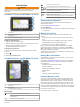
Chart Symbols
This table contains some of the common symbols you might see
on the detailed charts.
Icon Description
Buoy
Information
Marine services
Tide station
Current station
Overhead photo available
Perspective photo available
Other features common to most charts include depth contour
lines, intertidal zones, spot soundings (as depicted on the
original paper chart), navigational aids and symbols,
obstructions, and cable areas.
Navigating to a Point on the Chart
CAUTION
The Auto Guidance feature is based on electronic chart
information. That data does not ensure obstacle and bottom
clearance. Carefully compare the course to all visual sightings,
and avoid any land, shallow water, or other obstacles that may
be in your path.
When using Go To, a direct course and a corrected course may
pass over land or shallow water. Use visual sightings, and steer
to avoid land, shallow water, and other dangerous objects.
NOTE: The offshore Fishing chart is available with premium
charts, in some areas.
NOTE: Auto Guidance is available with premium charts, in some
areas.
1
From the Navigation chart or Fishing chart, select a location.
2
If necessary, select SELECT.
3
Select Navigate To.
4
Select an option:
• To navigate directly to the location, select Go To.
• To create a route to the location, including turns, select
Route To.
• To use Auto Guidance, select Auto Guidance.
5
Review the course indicated by the magenta line.
NOTE: When using Auto Guidance, a gray segment within
any part of the magenta line indicates that Auto Guidance
cannot calculate part of the Auto Guidance line. This is due to
the settings for minimum safe water depth and minimum safe
obstacle height.
6
Follow the magenta line, steering to avoid land, shallow
water, and other obstacles.
Viewing Location and Object Information on a Chart
You can view information about a location or an object on the
Navigation chart or the Fishing chart.
NOTE: The offshore Fishing chart is available with premium
charts, in some areas.
1
From the Navigation chart or Fishing chart, select a location
or object.
A list of options appears along the right side of the chart. The
options that appear vary based on the location or object you
selected.
2
Select an option:
• To navigate to the selected location, select Navigate To.
• To mark a waypoint at the cursor location, select New
Waypoint.
• To view the distance and bearing of the object from your
current location, select Measure Distance.
The distance and bearing appear on the screen. Select
Select to measure from a location other than your current
location.
• To view tide, current, celestial, chart notes, or local
services information near the cursor, select Information.
Viewing Details about Navaids
From the Navigation chart, Fishing chart, Perspective 3D chart
view, or Mariner’s Eye 3D chart view, you can view details about
various types of navigation aids, including beacons, lights, and
obstructions.
NOTE: The offshore Fishing chart is available with premium
charts, in some areas.
NOTE: Mariner's Eye 3D and Fish Eye 3D chart views are
available with premium charts, in some areas.
1
From a chart or 3D chart view, select a navaid.
2
Select the name of the navaid.
Selecting a Map
If your product has both BlueChart g2 and LakeVü
™
HD built-in
maps, you can select which map to use. Not all models have
both types of built-in maps.
1
From the Navigation chart, select Menu > Built-in Map.
2
Select an option:
• When you are on an inland lake, select LakeVü™ HD.
• When you are offshore, select BlueChart® g2.
Premium Charts
CAUTION
The Auto Guidance feature is based on electronic chart
information. That data does not ensure obstacle and bottom
clearance. Carefully compare the course to all visual sightings,
and avoid any land, shallow water, or other obstacles that may
be in your path.
NOTE: Not all models support all charts.
Optional premium charts, such as BlueChart g2 Vision
®
, allow
you to get the most out of your chartplotter. In addition to
detailed marine charting, premium charts may contain these
features, which are available in some areas.
Mariner’s Eye 3D: Provides a view from above and behind the
boat for a three-dimensional navigation aid.
Fish Eye 3D: Provides an underwater, three-dimensional view
that visually represents the sea floor according to the
information on the chart.
4 Charts and 3D Chart Views