
Owner`s manual
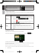

9NX501E/NZ501E
English
English
Owner’s Manual
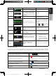
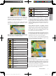
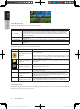
There is a field in the top left corner that displays the
next manoeuvre. Both the type of the event (turn,
roundabout, exiting motorway, etc.) and its distance
from the current position are displayed.
A smaller icon shows the type of the second next
manoeuvre if it is near the first one. Otherwise, only the
next manoeuvre is displayed.
Most of these icons are very intuitive. The following
table lists some of the frequently shown route events.
The same symbols are used in both fields:
Icon Description
Turn left.
Turn right.
Turn back.
Bear right.
Turn sharp left.
Keep left.
Continue straight in the intersection.
Go left on the roundabout, 3rd exit (next
manoeuvre).
Enter roundabout (second next
manoeuvre).
Enter motorway.
Exit motorway.
Board ferry.
Icon Description
Leave ferry.
Approaching a waypoint.
Approaching the destination.
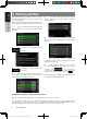
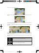
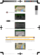
2.2.3.3 Lane information and Signposts
When navigating on multilane roads, it is important
to take the appropriate lane in order to follow the
recommended route. If lane information is available in
the map data, Clarion Mobile Map displays the lanes
and their directions using small arrows at the bottom
of the map. Highlighted arrows represent the lanes you
need to take.
Where additional information is available, signposts
substitute arrows. Signposts are displayed at the top
of the map. The colour and style of the signposts are
similar to the real ones you can see above road or by
the roadside. They show the available destinations and
the number of the road the lane leads to.
All signposts look similar when cruising (when there is
no recommended route). When navigating a route, only
the signpost that points to the lane(s) to be taken is
displayed in vivid colours; all others are darker.
If you want to hide the currently displayed signposts,
tap any of them and the normal Map screen returns until
new signpost information is received.
2.2.3.4 Junction view
If you are approaching a motorway exit or a complex
intersection and the needed information exists, the map
is replaced with a 3D view of the junction. The lanes you
need to take are displayed with arrows. Signposts can
also be present if information is available.
If you want to hide the currently displayed junction, tap
the picture and the Map screen returns.
Clarion_primo_1_1_EU_UserManual_EN-UK.indd 9 2011-2-23 11:23:23