
Users Manual Part 1

ALL
EFFECTIVITY
© Honeywell International Inc. Do not copy without express permission of Honeywell.
Page 2-38
22 Apr 2019
23-15-49
SYSTEM DESCRIPTION, INSTALLATION, AND MAINTENANCE MANUAL
ASPIRE-400
(a) Commands the safety Channel Card to terminate the Secondary context.
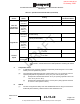
14. Aircraft Information
A. Navigation Information
(1) Navigation information can come from multiple sources on a given aircraft including:
(a) The Hybrid Inertial/GNSS Data source, the GNSS Data source and the Inertial
Data source. One or more LRU can be providing the same type of data. ARINC
781-6 indicates that the Hybrid Inertial/GNSS Data solution is the preferred
solution followed by the GNSS Data and then the Inertial Data and are given
priority accordingly.
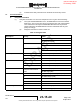
(b) Navigation information is shown in Table 2-6:
Table 2-6. Navigation Data
Description
Priority
Labels
Aircraft Position
1 254 Latitude Hybrid
255 Longitude Hybrid
2
110 Latitude GNSS
111 Longitude GNSS
3
310 Present Position Latitude (INS)
311 Present Position Longitude (INS)
Ground Speed
1
175 Ground Speed Hybrid
2 112 Ground Speed GNSS
3
312 Ground Speed (INS)
True Track 1 137 Track Angle True Hybrid
2
103 Track Angle True GNSS
3 313 Track Angle – True (INS)
Aircraft Pitch/Roll
There is no priority, the 1st
valid pair received will be
used.
324 Pitch Angle (INS)
325 Roll Angle (INS)
Altitude 1
262 Hybrid Height Above Ellipsoid (HAE)
2 370 GNSS Height (HAE)
3
261 Hybrid Altitude MSL
4
076 GNSS Altitude
5
361 Inertial Altitude
True Heading 1 132 True Heading Hybrid
2
314 True Heading (INS)
DRAFT
3rd rvw Draft as of:
29 January, 2020