
User guide

WMScanner GUI and Menus
Summit WMScanner Users Guide56
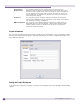
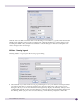
NOTE
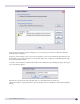
The latitude value must be within the range -90 to +90 and the longitude value must be within the range -180 to
+180. You can enter up to six decimal places in the latitude and longitude field. Summit WMScanner rounds the
seventh digit after the decimal point.
.
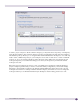
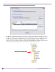
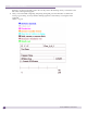
Click the OK button to record the points. You can re-record the points by clicking on the Pick Points
button. This overwrites the earlier recorded points. If you are satisfied with the recorded points, click
the Done button, to exit the dialog box or you can choose to Edit or Remove the geo-reference points.
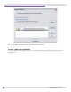
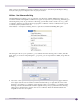
● Remove – this option allows you to remove the geo-reference points entered in the geo-reference
building. To remove the geo-reference points, click the Remove Points button.
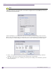
● Edit – this option allows you to edit the geo-location points. Clicking on the Edit button opens the
following dialog box.