
Manual


Operating Manual Flytec 6020
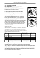
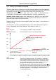
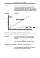
NORTH
WPT2
WPT1
DTK
Course
Track
Bearing
Distance
Crosstrack
erro
r
Course
erro
r
Speed
Caution: Track or Tracklog is also called the sequence of recorded positions during one
flight.
2.6.4 Waypoints and coordinates
A waypoint is any single point on the earth’s surface that you would like to go to.
The 6020-GPS can save up to 200 different waypoints. Each waypoint can have up
to 16 characters, e.g.
“Fiesch Airfield”. In determining the waypoint, it is also necessary
to enter the altitude, i.e.
“1123” meters (always above sea level). We now only need the
positioning of waypoint on the earth’s surface. For this purpose the 6020-GPS utilises the
geographical map system named WGS84 (World Geodetic System 1984).
This reference system assumes that latitude is measured from the equator to the North Pole
with 90° N, and to the South Pole with 90° S. Longitude is measured from the Greenwich
zero meridian (near London), East is counted positive and West is negative, up to +/- 180°.
The 6020-GPS also understands waypoints entered according to the previous norm,
introduced by Bräuniger: 3 letters and 3 numbers. Example: FIE112 indicates a waypoint
with the name FIExxx and an altitude of 1120 meters above sea level.
In Basic Settings / Coordinate Format the data entry format is selectable between:
1) Degrees Minutes Decimal places of Minutes (dd°mm.mmm) (Factory setting)
2) Degrees Minutes Seconds (dd°mm’ss“)
3) Degrees Decimal places of degrees (dd.ddddd)
4) UTM (a grid system with 1 km raster in both NS and also in EW direction)
5) Swiss Grid
Basically one should always select the first possibility (=factory setting), because only this
format is using exactly the same calculation format as the GPS receivers do. With all the
other formats rounding errors could sum up to 20 m.
Computing is only done with the WGS84 system. Differing geodetic systems can no longer
be selected.
- 20 -