
Manual


Operating Manual Flytec 6020
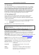
Earth radius
=6360km
Satellite orbit radius
=26560km
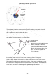
The position is derived from a triangulation. The GPS receiver measures the time of the
signals and calculates the distance to the respective satellite by taking into account the
speed of light. Based on three satellites the horizontal position can be determined, and
with 4 satellites the spatial position with altitude.
You can find a good explanation of the involved calculation on Wikipedia.
For a spatial position determination (3D position) there are needed 4 satellites,
one satellite is hereby required for synchronisation.
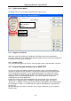
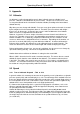
90°
Best Accuracy is achieved if the angle
between 2 satellites is 90°. The
spanned triangle between one’s own
position and the two involved satellites
then has the largest possible surface
area. The unit DOP (Dilution Of
Position) is proportional to the inverse
value of this area
4th Satellite for time
Synchronisation
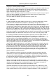
In case of a 3D position identification, best accuracy is achieved if the 3 satellites are 90°
to each other. In this case the volume of the spanned pyramid is the biggest.
Again the DOP (Dilution Of Position) is the inverse value to the volume of this pyramid.
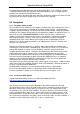
For a good 2 D position on the earth surface it is best, if you have 2 satellites at 90° near
the horizon. So for example, one to the North, the other one to the East. The 3rd satellite
vertically above the position does not contribute to accuracy, it just gives a rough information
of the altitude, but which is good enough for a good lat/long determination.
- 49 -