
Operator's Manual


APPENDIX 4 DIGITAL INTERFACE
AP-13
SSD-AIS ship static data
THS-True heading and status
VBW-Dual ground/water speed
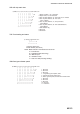
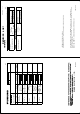
$--SSD,c--c,c--c,xxx,xxx,xx,xx,c, aa*hh<CR><LF>
| | | | | | | | |
| | | | | | | | +--9
| | | | | | | +--- 8
| | | | | | +----- 7
| | | | | +------- 6
| | | | +---------- 5
| | | +-------------- 4
| | +------------------ 3
| +---------------------- 2
+--------------------------- 1
1. Ship's Call Sign, 1 to 7 characters
2. Ship's Name, 1 to 20 characters
3. Pos. ref. point distance, "A," from bow, 0 to 511 Meters
4. Pos. ref. point distance, "B," from stern,
0 to 511 Meters
5. Pos. ref. point distance, "C," from port beam,
0 to 63 Meters
6. Pos. ref. point distance, "D," from starboard beam,
0 to 63 Meters
7. DTE indicator flag
8. Not used
9. Checksum
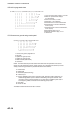
$--THS,x.x,a*hh<CR><LF>
| |
| +----------- 2
+---------------- 1
1. Heading, degrees true
2. Mode indicator (See NOTE.)
NOTE: Mode indicator. This field shoud not be null.
A = Autonomous
E = Estimated (dead reckoning)
M = Manual input
S = Simulator mode
V = Data not valid (including standby)
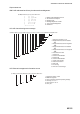
$--VBW,x.x,x.x,A,x.x,x.x,A,x.x,A,x.x,A*hh<CR><LF>
| | | | | | | | | | |
| | | | | | | | | | +--- 11
| | | | | | | | | +----- 10
| | | | | | | | +-------- 9
| | | | | | | +----------- 8
| | | | | | +-------------- 7
| | | | | +----------------- 6
| | | | +-------------------- 5
| | | +------------------------ 4
| | +--------------------------- 3
| +------------------------------ 2
+---------------------------------- 1
1. Not used
2. Not used
3. Not used
4. Longitudinal ground speed, knots
5. Transverse ground speed, knots
6. Status: ground speed, A=data valid V=data invalid
7. Not used
8. Not used
9. Not used
10. Not used
11. Checksum