
Operation Manual


2. CHART PLOTTER
2-10
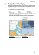
[S-52 Vector Chart Display Mode]: Set the level of information to show on the chart.
The selections are [Custom], [Base], [Standard], [Other], and [Fishing]. The chart fea-
tures are turned on or off according to setting.
Note: The following menu items except [Reset Default Settings] are unavailable when
you select the mode other than [Custom].
[Unknown Object]: Show or hide unknown objects that appear on the chart.
[Chart Data Coverage]: Show or hide the geographic names and geographic objects.
[Water and Seabed Features]: Show or hide the water and seabed presentation.
[Traffic Routes]: Show or hide the marine traffic routes.
[Information Areas]: Show or hide the information areas that appear on the chart.
[Buoys & Beacons]: Show or hide the buoys and beacons.
[Lights]: Show or hide the sector of light that a fixed beacon shines.
[Fog Signals]: Show or hide the structure that sends a fog signal.
[Radar]: Show or hide the radar buoy.
[Information About Chart Data]: Show or hide the chart data information.
[Obstructions]: Show or hide obstructions (wrecks, etc.)
[Depth Contours, Currents, Magnetics]: Show or hide the depth contours, tidal cur-
rents and magnetics.
[Fishing Facilities]: Show or hide the location of fishing facilities.
[Services (Pilot, Signal Stations)]: Show or hide the location of pilots and signal sta-
tions.
[Harbour Facilities]: Show or hide the location of harbour facilities.
[Services and Small Craft Facilities]: Show or hide the services for ship and small craft.
[Land Features]: Show or hide the cartographic features that are shown on land.
[Reset Default Settings]: Select this menu item to restore default settings for the [S-52
Display] menu.
2.10 Alarms
The various plotter alarms alert you (with audiovisual alarms) when the conditions
specified are met. These alarms are:
• XTE alarm
• Depth alarm
• Sea surface temperature alarm
• Speed alarm
• Anchor watch alarm