
Product Manual

Sensors Settings
Compass Settings
Hold MENU, and select Settings > Sensors & Accessories >
Compass.
Calibrate: Allows you to manually calibrate the compass sensor
(Calibrating the Compass Manually, page 22).
Display: Sets the directional heading on the compass to letters,
degrees, or milli-radians.
North Ref.: Sets the north reference of the compass (Setting the
North Reference, page 22).
Mode: Sets the compass to use electronic-sensor data only
(On), a combination of GPS and electronic-sensor data when
moving (Auto), or GPS data only (Off).
Calibrating the Compass Manually
NOTICE
Calibrate the electronic compass outdoors. To improve heading
accuracy, do not stand near objects that influence magnetic
fields, such as vehicles, buildings, and overhead power lines.
Your device was already calibrated at the factory, and the
device uses automatic calibration by default. If you experience
irregular compass behavior, for example, after moving long
distances or after extreme temperature changes, you can
manually calibrate the compass.
1
Hold MENU.
2
Select Settings > Sensors & Accessories > Compass >
Calibrate > Start.
3
Follow the on-screen instructions.
TIP: Move your wrist in a small figure eight motion until a
message appears.
Setting the North Reference
You can set the directional reference used in calculating
heading information.
1
Hold MENU.
2
Select Settings > Sensors & Accessories > Compass >
North Ref..
3
Select an option:
• To set geographic north as the heading reference, select
True.
• To set the magnetic declination for your location
automatically, select Magnetic.
• To set grid north (000º) as the heading reference, select
Grid.
• To set the magnetic variation value manually, select User,
enter the magnetic variance, and select Done.
Altimeter Settings
Hold MENU, and select Settings > Sensors & Accessories >
Altimeter.
Auto Cal.: Allows the altimeter to self-calibrate each time you
turn on GPS tracking.
Calibrate: Allows you to manually calibrate the altimeter sensor.
Calibrating the Barometric Altimeter
Your device was already calibrated at the factory, and the
device uses automatic calibration at your GPS starting point by
default. You can manually calibrate the barometric altimeter if
you know the correct elevation.
1
Hold MENU.
2
Select Settings > Sensors & Accessories > Altimeter.
3
Select an option:
• To calibrate automatically from your GPS starting point,
select Auto Cal. > On.
• To enter the current elevation, select Calibrate.
Barometer Settings
Hold MENU, and select Settings > Sensors & Accessories >
Barometer.
Plot: Sets the time scale for the chart in the barometer widget.
Storm Alert: Sets the rate of barometric pressure change that
triggers a storm alert.
Watch Mode: Sets the sensor used in watch mode. The Auto
option uses both the altimeter and barometer according to
your movement. You can use the Altimeter option when your
activity involves changes in altitude, or the Barometer option
when your activity does not involve changes in altitude.
Map Settings
You can customize how the map appears in the map app and
data screens.
Hold MENU, and select Settings > Map.
Orientation: Sets the orientation of the map. The North Up
option shows north at the top of the screen. The Track Up
option shows your current direction of travel at the top of the
screen.
User Locations: Shows or hides saved locations on the map.
Auto Zoom: Automatically selects the zoom level for optimal
use of your map. When disabled, you must zoom in or out
manually.
Navigation Settings
You can customize the map features and appearance when
navigating to a destination.
Customizing Map Features
1
Hold MENU.
2
Select Settings > Navigation > Data Screens.
3
Select an option:
• Select Map to turn on or off the map.
• Select Guide to turn on or off the guide screen that
displays the compass bearing or course to follow while
navigating.
• Select Elevation Plot to turn on or off the elevation plot.
• Select a screen to add, remove, or customize.
Heading Settings
You can set the behavior of the pointer that appears when
navigating.
Hold MENU, and select Settings > Navigation > Type.
Bearing: Points in the direction of your destination.
Course: Shows your relationship to the course line leading to
the destination (Course Pointer, page 22).
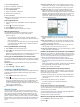
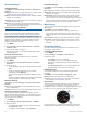
Course Pointer
The course pointer is most useful when you are navigating to
your destination in a straight line, such as when you are
navigating on water. It can help you navigate back to the course
line when you go off-course to avoid obstacles or hazards.
The course pointer
À
indicates your relationship to the course
line leading to the destination. The course deviation indicator
22 Customizing Your Device