
User Manual


Table Of Contents
- Table of Contents
- Introduction
- Customizing the Chartplotter
- ActiveCaptain App
- Charts and 3D Chart Views
- Navigation Chart and Fishing Chart
- Zooming In and Out of the Chart
- Panning the Chart with the Keys
- Selecting an Item on the Map Using the Device Keys
- Chart Symbols
- Measuring a Distance on the Chart
- Creating a Waypoint on the Chart
- Navigating to a Point on the Chart
- Viewing Location and Object Information on a Chart
- Viewing Details about Navaids
- Heading Line and Angle Markers
- Premium Charts
- Automatic Identification System
- Chart and 3D Chart View Settings
- Supported Maps
- Navigation Chart and Fishing Chart
- Garmin Quickdraw Contours Mapping
- Mapping a Body of Water Using the Garmin Quickdraw Contours Feature
- Adding a Label to a Garmin Quickdraw Contours Map
- Garmin Quickdraw Community
- Garmin Quickdraw Contours Settings
- Navigation with a Chartplotter
- Basic Navigation Questions
- Destinations
- Courses
- Stopping Navigation
- Waypoints
- Routes
- Auto Guidance
- Setting and Following an Auto Guidance Path
- Creating an Auto Guidance Path
- Filtering a List of Routes and Auto Guidance Paths
- Reviewing an Auto Guidance Path
- Adjusting an Auto Guidance Path
- Canceling an Auto Guidance Calculation in Progress
- Setting a Timed Arrival
- Adjusting the Distance from Shore
- Auto Guidance Path Configurations
- Tracks
- Showing Tracks
- Setting the Color of the Active Track
- Saving the Active Track
- Viewing a List of Saved Tracks
- Editing a Saved Track
- Saving a Track as a Route
- Browsing for and Navigating a Recorded Track
- Deleting a Saved Track
- Deleting All Saved Tracks
- Retracing the Active Track
- Clearing the Active Track
- Managing the Track Log Memory During Recording
- Configuring the Recording Interval of the Track Log
- Boundaries
- Sonar Fishfinder
- Stopping the Transmission of Sonar Signals
- Changing the Sonar View
- Traditional Sonar View
- Garmin ClearVü Sonar View
- SideVü Sonar View
- Panoptix Sonar Views
- Selecting the Transducer Type
- Creating a Waypoint on the Sonar Screen
- Pausing the Sonar Display
- Viewing Sonar History
- Sonar Sharing
- Adjusting the Level of Detail
- Adjusting the Color Intensity
- Sonar Recordings
- Traditional, Garmin ClearVü, and SideVü Sonar Setup
- Panoptix Sonar Setup
- Autopilot
- Sailing Features
- Gauges and Graphs
- Tide, Current, and Celestial Information
- Digital Selective Calling
- Media Player
- Opening the Media Player
- Selecting the Media Source
- Playing Music
- Adjusting the Volume
- VHF Radio
- Radio
- DAB Playback
- SiriusXM Satellite Radio
- Setting the Device Name
- Updating the Media Player Software
- Device Configuration
- Sharing and Managing User Data
- Connecting to a Garmin Device to Share User Data
- Selecting a File Type for Third-Party Waypoints and Routes
- Copying User Data from a Memory Card
- Copying User Data to a Memory Card
- Copying Built-In Maps to a Memory Card
- Copying Waypoints, Routes, and Tracks from HomePort to a Chartplotter
- Backing Up Data to a Computer
- Restoring Backup Data to a Chartplotter
- Saving System Information to a Memory Card
- Clearing Saved Data
- Appendix
- Index
Viewing a Position Report
1
Select Nav Info > Other Vessels > DSC List.
2
Select a position-report call.
3
Select an option:
• To switch to position report details, select .
• To switch to a Navigation chart marking the location,
select .
• To switch to a Navigation chart marking the location,
select Next Page.
• To view the position report details, select Previous Page.
Navigating to a Tracked Vessel
1
Select Nav Info > Other Vessels > DSC List.
2
Select a position-report call.
3
Select Navigate To.
4
Select Go To or Route To.
Creating a Waypoint at the Position of a Tracked
Vessel
1
Select Nav Info > Other Vessels > DSC List.
2
Select a position-report call.
3
Select Create Waypoint.
Editing Information in a Position Report
1
Select Nav Info > Other Vessels > DSC List.
2
Select a position-report call.
3
Select Edit.
• To enter the name of the vessel, select Name.
• To select a new symbol, select Symbol, if available.
• To enter a comment, select Comment.
• To show a trail line for the vessel if your radio is tracking
the position of the vessel, select Trail.
• To select a color for the trail line, select Trail Line.
Deleting a Position-Report Call
1
Select Nav Info > Other Vessels > DSC List.
2
Select a position-report call.
3
Select Edit > Clear Report.
Viewing Vessel Trails on the Chart
You can view trails for all tracked vessels on some chart views.
By default, a black line indicates the path of the vessel, a black
dot indicates each previously reported position of a tracked
vessel, and a blue flag indicates the last reported position of the
vessel.
1
From a chart or 3D chart view, select MENU > Other
Vessels > DSC Trails.
2
Select the number of hours to show tracked vessels on the
chart.
For example, if you select 4 Hours, all trail points that are
less than four hours old appear for all tracked vessels.
Individual Routine Calls
When you connect the chartplotter to a Garmin VHF radio, you
can use the chartplotter interface to set up an individual routine
call.
When setting up an individual routine call from your chartplotter,
you can select the DSC channel on which you want to
communicate. The radio transmits this request with your call.
Selecting a DSC Channel
NOTE: The selection of a DSC channel is limited to those
channels that are available in all frequency bands. The default
channel is 72. If you select a different channel, the chartplotter
uses that channel for subsequent calls until you call using
another channel.
1
Select Nav Info > Other Vessels > DSC List.
2
Select a vessel or a station to call.
3
Select Call with Radio > Channel.
4
Select an available channel.
Making an Individual Routine Call
NOTE: When initiating a call from the chartplotter, if the radio
does not have an MMSI number programmed, the radio will not
receive call information.
1
Select Nav Info > Other Vessels > DSC List.
2
Select a vessel or a station to call.
3
Select Call with Radio.
4
If necessary, select Channel, and select a new channel.
5
Select Send.
The chartplotter sends information about the call to the radio.
6
On your Garmin VHF radio, select Call.
Making an Individual Routine Call to an AIS Target
1
From a chart or 3D chart view, select an AIS target.
2
Select AIS Vessel > Call with Radio.
3
If necessary, select Channel, and select a new channel.
4
Select Send.
The chartplotter sends information about the call to the radio.
5
On your Garmin VHF radio, select Call.
Media Player
NOTE: The media player feature is not compatible with all
chartplotter models.
NOTE: Not all features are available on all connected media
players.
If you have a compatible stereo connected to the NMEA 2000
network, you can control the stereo using the chartplotter. The
chartplotter should automatically detect the media player when it
is first connected.
You can play media from sources connected to the media player
and sources connected to the NMEA 2000 network.
Opening the Media Player
Before you can open the media player, you must connect a
compatible device to the chartplotter.
Select Media.
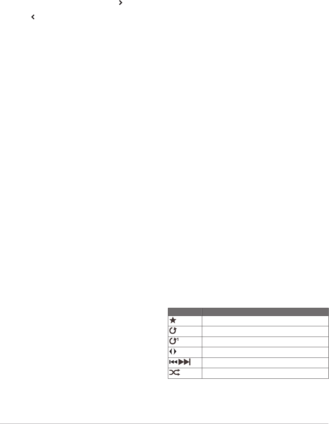
Icons
NOTE: Not all devices have these icons.
Icon Description
Saves or deletes a channel as a preset
Repeats all songs
Repeats one song
Scans for stations
Searches for stations or skips songs
Shuffles
Selecting the Media Source
When you have multiple media devices connected on a network,
such as the NMEA 2000 network, you can select the media
source you want to control from your chartplotter.
30 Media Player