
User Manual
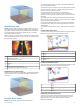

Shoreline Distance: Sets how close to the shore you want the
Auto Guidance path to be placed. The
Auto Guidance path
may move if you change this setting while navigating. The
available values for this setting are relative, not absolute. To
ensure that the Auto Guidance line is placed the appropriate
distance from shore, you can assess the placement of the
Auto Guidance path using one or more familiar destinations
that require navigation through a narrow waterway (
Adjusting
the Distance from Shore,
page
16).
Tracks
A track is a recording of the path of your boat. The track
currently being recorded is called the active track, and it can be
saved. You can show tracks in each chart or 3D chart view.
Showing Tracks
Select Nav Info
> Tracks > Tracks
.
A trailing line on the chart indicates your track.
Setting the Color of the Active Track
1
Select Nav Info > Tracks > Active Track Options > Track
Color.
2
Select a track color.
Saving the Active Track
The track currently being recorded is called the active track.
1
Select Nav Info >
Tracks > Save Active Track
.
2
Select an option:
• Select the time the active track began.
• Select
Entire Log.
Viewing a List of Saved Tracks
Select Nav Info > Tracks > Saved Tracks.
Editing a Saved Track
1
Select Nav Info > Tracks >
Saved Tracks
.
2
Select a track.
3
Select
Edit Track.
4
Select an option:
• Select
Name, and enter the new name.
• Select Track Color
, and select a color.
Saving a Track as a Route
1
Select Nav Info > Tracks >
Saved Tracks
.
2
Select a track.
3
Select Edit Track
> Save As > Save as Route
.
Browsing for and Navigating a Recorded Track
Before you can browse a list of tracks and navigate to them, you
must record and save at least one track (Tracks
, page
17).
1
Select Nav Info > Tracks >
Saved Tracks
.
2
Select a track.
3
Select
Follow Track.
4
Select an option:
• To navigate the track from the starting point used when
the track was created, select Forward
.
• To navigate the track from the destination point used
when the track was created, select Backward
.
5
Review the course indicated by the colored line.
6
Follow the line along each leg in the route, steering to avoid
land, shallow water, and other obstacles.
Deleting a Saved Track
1
Select Nav Info > Tracks > Saved Tracks.
2
Select a track.
3
Select
Delete.
Deleting All Saved Tracks
Select Nav Info
> Manage Data > Clear User Data > Saved
Tracks
.
Retracing the Active Track
The track currently being recorded is called the active track.
1
Select Nav Info
> Tracks > Follow Active Track
.
2
Select an option:
• Select the time the active track began.
• Select
Entire Log.
3
Review the course indicated by the colored line.
4
Follow the colored line, steering to avoid land, shallow water,
and other obstacles.
Clearing the Active Track
Select Nav Info > Tracks > Clear Active Track.
The track memory is cleared, and the active track continues
to be recorded.
Managing the Track Log Memory During Recording
1
Select Nav Info
> Tracks > Active Track Options
.
2
Select Record Mode
.
3
Select an option:
• To record a track log until the track memory is full, select
Fill
.
• To continuously record a track log, replacing the oldest
track data with new data, select Wrap
.
Configuring the Recording Interval of the Track Log
You can indicate the frequency at which the track plot is
recorded. Recording more frequent plots is more accurate but
fills the track log faster. The resolution interval is recommended
for the most efficient use of memory.
1
Select Nav Info > Tracks > Active Track Options > Record
Interval > Interval.
2
Select an option:
• To record the track based on a distance between points,
select Distance > Change, and enter the distance.
• To record the track based on a time interval, select Time
>
Change
, and enter the time interval.
• To record the track plot based on a variance from your
course, select Resolution > Change, and enter the
maximum error allowed from the true course before
recording a track point.
Boundaries
Boundaries allow you to avoid or remain in designated areas in
a body of water. You can set an alarm to alert you when you
enter or exit a boundary.
You can create boundary areas, lines, and circles using the
map. You can also convert saved tracks and routes into
boundary lines. You can create a boundary area using
waypoints by creating a route from the waypoints, and
converting the route into a boundary line.
You can select a boundary to act as the active boundary. You
can add the active boundary data to the data fields on the chart.
Creating a Boundary
1
Select Nav Info > Boundaries > New Boundary.
2
Select a boundary shape.
3
Follow the on-screen instructions.
Boundary Display Settings
Select Nav Info
> Boundaries > Display Options
.
Distance/Bearing: Allows you to hide or display the bearing and
distance to your destination for the active boundary.
Navigation with a Chartplotter 17