Garmin Drive™ 40/50/60 Benutzerhandbuch Januar 2016 190-01920-32_0A
Alle Rechte vorbehalten. Gemäß Urheberrechten darf dieses Handbuch ohne die schriftliche Genehmigung von Garmin weder ganz noch teilweise kopiert werden. Garmin behält sich das Recht vor, Änderungen und Verbesserungen an seinen Produkten vorzunehmen und den Inhalt dieses Handbuchs zu ändern, ohne Personen oder Organisationen über solche Änderungen oder Verbesserungen informieren zu müssen. Unter www.garmin.com finden Sie aktuelle Updates sowie zusätzliche Informationen zur Verwendung dieses Produkts.
Inhaltsverzeichnis Erste Schritte.................................................................. 1 Support und Updates .................................................................. 1 Aktualisieren von Karten und Software mit Garmin Express .................................................................................. 1 Übersicht über das Gerät ............................................................ 1 Übersicht über das Garmin Drive 40 Gerät ............................
Anschlusskabel ......................................................................... 14 Aufladen des Geräts ............................................................ 14 Gerätewartung.............................................................. 14 Pflege des Geräts ..................................................................... 14 Reinigen des Gehäuses ...................................................... 14 Reinigen des Touchscreens ................................................
Erste Schritte WARNUNG Lesen Sie alle Produktwarnungen und sonstigen wichtigen Informationen in der Anleitung "Wichtige Sicherheits- und Produktinformationen", die dem Produkt beiliegt. • Aktualisieren Sie die Karten und die Software des Geräts (Aktualisieren von Karten und Software mit Garmin Express, Seite 1). • Bringen Sie das Gerät im Fahrzeug an, und schließen Sie es an die Stromversorgung an (Verbinden des Geräts mit der Stromversorgung des Fahrzeugs, Seite 2).
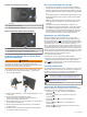
Garmin Drive 50 Device Overview À Á Â Power key USB power and data port Map and data memory card slot Übersicht über das Garmin Drive 60 Gerät Ein und Ausschalten des Geräts • Schalten Sie das Gerät ein, indem Sie die Einschalttaste drücken oder das Gerät mit der Stromversorgung verbinden. • Aktivieren Sie den Energiesparmodus des Geräts, indem Sie die Einschalttaste drücken, während das Gerät eingeschaltet ist.
Anpassen der Lautstärke 1 Wählen Sie Lautstärke. 2 Wählen Sie eine Option: • Passen Sie die Lautstärke mithilfe des Schiebereglers an. • Wählen Sie , um den Ton des Geräts stumm zu schalten. • Wählen Sie , um weitere Optionen anzuzeigen. Einstellen der Bildschirmhelligkeit 1 Wählen Sie Einstellungen > Anzeige > Helligkeit. 2 Passen Sie die Helligkeit mithilfe des Schiebereglers an.
• Wählen Sie > Route bearbeiten, und fügen Sie der Route Routenpunkte hinzu, um den Verlauf der Route zu bearbeiten (Anpassen der Route, Seite 5). Das Gerät berechnet eine Route zum Ziel, und führt Sie mithilfe von Sprachansagen und Informationen auf der Karte dorthin (Anzeige der Route auf der Karte, Seite 4). Eine Vorschau der Hauptverkehrsstraßen der Route wird mehrere Sekunden lang am Rand der Karte angezeigt.
2 Suchen Sie nach einer Position (Suchen und Speichern von Positionen, Seite 7). 3 Wählen Sie einen Favoriten. 4 Wählen Sie Los!. 5 Wählen Sie eine Option: • Wählen Sie Als nä. Stopp hinzu, um die Position als nächstes Ziel der Route hinzuzufügen. • Wählen Sie Als letzt. Stopp hinzu, um die Position am Ende der Route einzufügen. • Wählen Sie Der Route hinzufügen, um die Position hinzuzufügen und die Reihenfolge der Ziele in der Route anzupassen.
4 Wählen Sie eine Option: • Verschieben Sie die Position nach oben oder unten, indem Sie wählen und die Position an eine neue Stelle in der Reise ziehen. • Fügen Sie nach der ausgewählten Position eine neue Position hinzu, indem Sie wählen. • Entfernen Sie die Position, indem Sie wählen. Bearbeiten und Speichern der aktiven Route Wenn eine Route aktiv ist, können Sie die Route mit der Routenplanung bearbeiten und als Reise speichern. 1 Wählen Sie Apps > Routenplanung > der Route.
• Damit Mautgebiete immer vermieden werden, wählen Sie Vermeiden. • Damit Mautgebiete immer zugelassen werden, wählen Sie Zulassen. Wählen Sie Speichern. 4 Vermeiden von Straßenmerkmalen 1 Wählen Sie Einstellungen > Navigation > Vermeidungen. 2 Wählen Sie die Straßenmerkmale aus, die auf der Route vermieden werden sollen, und wählen Sie Speichern. Vermeiden von Umweltzonen Das Gerät kann Gebiete mit umweltbedingten Beschränkungen und Emissionsbeschränkungen vermeiden, die evtl. für Ihr Fahrzeug gelten.
• Suchen Sie nach einer Stadt, indem Sie die Stadt und jeweils das Bundesland, die Provinz oder das Land eingeben. • Suchen Sie nach Koordinaten, indem Sie die Breiten- und Längengrade eingeben. 5 Wählen Sie eine Option: • Suchen Sie nach einem vorgeschlagenen Suchbegriff, indem Sie den Begriff auswählen. • Suchen Sie nach dem eingegebenen Text, indem Sie auswählen. 6 Wählen Sie bei Bedarf eine Position aus.
3 Wählen Sie die Kreuzung. Suchen von Städten 1 Wählen Sie Zieleingabe > POIs > Städte. 2 Wählen Sie eine Option: • Wählen Sie aus der Liste in der Nähe befindlicher Städte eine Stadt aus. • Suchen Sie in der Nähe einer anderen Position, indem Sie Suche bei: wählen (Ändern des Suchgebiets, Seite 8). • Suchen Sie nach einer Stadt nach Name, indem Sie Suchbegriff eing. wählen, einen Städtenamen eingeben und wählen.
5 Geben Sie einen oder mehrere POI-Namen ein. Trennen Sie diese durch Komma voneinander. 6 Wählen Sie bei Bedarf einen vorgeschlagenen POI. 7 Wählen Sie Fertig. Löschen von Favoriten HINWEIS: Gelöschte Favoriten können nicht wiederhergestellt werden. 1 Wählen Sie Zieleingabe > Favoriten. 2 Wählen Sie > Favoriten löschen. 3 Aktivieren Sie das Kontrollkästchen neben den zu löschenden Favoriten, und wählen Sie Löschen.
3 Wählen Sie eine Option. Das neue Reisedatenfeld wird in den Kartenextras für Reisedaten angezeigt. Anzeigen der Reiseinformationsseite Auf der Reiseinformationsseite werden das Tempo sowie Statistiken zur Reise angezeigt. HINWEIS: Wenn Sie die Fahrt häufig unterbrechen, lassen Sie das Gerät eingeschaltet, damit die Reisezeit genau erfasst werden kann. Wählen Sie auf der Karte die Option Tempo. Anzeigen der Reiseaufzeichnung Das Gerät führt eine Reiseaufzeichnung durch, d. h.
Wenn Sie sich in einem abgedeckten Verkehrsfunkgebiet befinden, kann das Gerät Verkehrsinformationen anzeigen und Ihnen dabei helfen, Verkehrsbehinderungen zu vermeiden. Informationen zu Verkehrsfunkabonnements Sie können zusätzliche Abonnements erwerben oder Ihr Abonnement erneuern, falls es abläuft. Rufen Sie die Website http://www.garmin.com/traffic auf. Anzeigen von Verkehrsfunkabonnements Wählen Sie Einstellungen > Verkehr > Abonnements.
Festlegen einer simulierten Position Wenn Sie sich in einem Gebäude befinden oder keine Satellitensignale empfangen, können Sie mithilfe des GPS eine simulierte Position einrichten. 1 Wählen Sie Einstellungen > Navigation > GPSSimulation. 2 Wählen Sie im Hauptmenü die Option Karte. 3 Tippen Sie zweimal auf die Karte, um ein Gebiet auszuwählen. Die Adresse der Position wird unten im Bildschirm angezeigt. 4 Wählen Sie die Positionsbeschreibung aus. 5 Wählen Sie Position setzen.
Einstellungen für Annäherungsalarme HINWEIS: Es müssen Benutzer-POIs (Points of Interest) geladen sein, damit Annäherungsalarme angezeigt werden. HINWEIS: Diese Funktion ist nicht in allen Gebieten verfügbar. Wählen Sie Einstellungen > Alarme. Alarmtyp: Ändert den Alarmtyp, der ertönt, wenn Sie sich Punkten mit Annäherungsalarmen nähern. Alarme: Ändert die Punkte mit Annäherungsalarmen, für die Alarme ertönen.
Entfernen der Saugnapfhalterung von der Wind schutzscheibe 1 Klappen Sie den Hebel der Saugnapfhalterung in Ihre Richtung. 2 Ziehen Sie die Lasche an der Saugnapfhalterung in Ihre Richtung. Austauschen der Sicherung des KFZ Anschlusskabels HINWEIS Achten Sie darauf, dass Sie beim Austauschen der Sicherung keine Kleinteile verlieren, und stellen Sie sicher, dass diese wieder an der richtigen Stelle angebracht werden. Das KFZAnschlusskabel funktioniert nur, wenn es ordnungsgemäß zusammengesetzt ist.
mapping software. The device supports microSD™ memory cards from 4 to 64 GB. 1 Locate the memory card slot on your device (Übersicht über das Gerät, page 1). 2 Insert a memory card into the slot. 3 Press it in until it clicks. 2 Klicken Sie auf die Registerkarte Karten. 3 Folgen Sie den Anweisungen auf dem Bildschirm. Erwerben von Zubehör Rufen Sie die Website garmin.com/accessories auf. Datenverwaltung Sie können Dateien auf dem Gerät speichern.
Index Symbole 2D-Kartenansicht 11 3D-Kartenansicht 11 A Abbiegeliste 4 Adressen, suchen 8 Akku, aufladen 2, 14, 15 aktualisieren Karten 1 Software 1 Aktuelle Position 9 Alarme für Fahrer 3 Anbringen des Geräts aus Halterung nehmen 14 Auto 2 Saugnapfhalterung 2, 15 Ändern des Suchgebiets 8 Annäherungsalarme, Einstellungen 14 Anpassen des Geräts 12 Anpassen von Routen 5 Anschlusskabel 14 Austauschen der Sicherung 15 Fahrzeug 2 Anweisungen 4 Anzeigeeinstellungen 13 Audio, Annäherungsalarme 14 Aufladen des Ger
Zubehör 16 Zurücksetzen Gerät 14 Reisedaten 11 18 Index
www.garmin.