Garmin Drive™ 40/50/60 Руководство пользователя Январь 2016 190-01920-45_0A
Все права сохранены. Согласно законодательству о защите авторских прав полное или частичное копирование данного руководства без письменного разрешения компании Garmin не допускается. Компания Garmin оставляет за собой право изменять или улучшать свои продукты и вносить изменения в содержание данного руководства без обязательства уведомлять какое-либо лицо или организацию о таких изменениях или улучшениях.
Содержание Начало работы.............................................................. 1 Поддержка и обновления ......................................................... 1 Обновление карт и ПО с помощью Garmin Express .......... 1 Обзор устройств ........................................................................ 1 Garmin Drive 40 — обзор устройства .................................. 1 Garmin Drive 50 — обзор устройства .................................. 2 Garmin Drive 60 — обзор устройства ...........
Настройки оповещений о сближении .................................... 14 Настройки устройства и конфиденциальности .................... 14 Восстановление настроек ...................................................... 15 Информация об устройстве..................................... 15 Технические характеристики ................................................. 15 Кабели питания ....................................................................... 15 Зарядка устройства ....................................
Начало работы ОСТОРОЖНО Сведения о безопасности и другую важную информацию см. в руководстве Правила техники безопасности и сведения об изделии, которое находится в упаковке изделия. • Обновите карты и программное обеспечение на устройстве (Обновление карт и ПО с помощью Garmin Express, стр. 1). • Установите устройство на транспортное средство и подключите его к источнику питания (Подключение автомобильного кабеля питания к устройству, стр. 2).
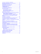
Garmin Drive 50 — обзор устройства 5 Нажмите на нижнюю часть держателя, чтобы он зафиксировался в устройстве (должен прозвучать щелчок). 6 Вставьте другой конец автомобильного кабеля питания в гнездо прикуривателя автомобиля.
• Чтобы вернуться на предыдущий экран меню, выберите . • Чтобы быстро перейти в главное меню, нажмите и удерживайте кнопку . • Для прокрутки списков или меню выберите или . • Чтобы увеличить скорость прокрутки, нажмите и удерживайте или . • Чтобы открыть контекстное меню с опциями для текущего экрана, выберите . Регулировка громкости 1 Выберите Громкость. 2 Выберите один из вариантов. • Измените уровень громкости при помощи ползунка. • Чтобы отключить звук устройства, выберите .
Навигация к пункту назначения Маршруты Маршрут — это путь следования из текущего местоположения в один или несколько пунктов назначения. • Устройство рассчитывает рекомендуемый маршрут к пункту назначения в соответствии с установленными параметрами, включая режим расчета маршрутов (Изменение режима расчета маршрута, стр. 5) и объезды (Предотвращение задержек в движении по маршруту, объезд платных дорог и определенных областей, стр. 7).
1 На странице карты выберите один из вариантов: 3 Выберите местоположение на карте. • Чтобы просматривать предстоящие повороты и указания во время навигации по маршруту, выберите > Повороты. Инструмент карты обеспечивает отображение следующих четырех поворотов или указаний рядом с картой. По мере движения по маршруту список обновляется автоматически. • Чтобы просмотреть полный список поворотов и указаний по всему маршруту, коснитесь текстовой строки в верхней части карты.
планируете отправиться в поездку. Если вы начнете поездку из другого местоположения, устройство обеспечивает возможность сначала проследовать в начальную точку. В случае поездки туда и обратно начальная точка и конечный пункт назначения могут совпадать. 1 Выберите Приложения > Планировщ. маршр. > > Создать поездку. 2 Нажмите Выбрать начальный пункт. 3 Выберите местоположение для начальной точки и нажмите Выбр.. 4 Выберите пункт Выбрать пункт назначения.
Предотвращение задержек в движении по маршруту, объезд платных дорог и определенных областей Объезд заторов на маршруте Чтобы иметь возможность объезда заторов, необходимо получать информацию о дорожной обстановке (Прием данных о дорожной обстановке через приемник трафика, стр. 12). По умолчанию устройство оптимизирует маршрут, чтобы автоматически избежать простаивания в заторах. В случае отключения этой функции в настройках трафика (Настройки данных о дорожной обстановке, стр.
• Чтобы удалить один пользовательский объезд, укажите объезд и выберите пункт > Удалить. Навигация напрямик Если вы сворачиваете с дороги, установите режим "Напрямик". 1 Выберите пункт Настройки > Навигация. 2 Выберите пункт Режим расчета маршрутов > Напрямик > Сохр.. Следующий маршрут будет рассчитываться по прямой линии к указанному местоположению.
Навигация к объектам, расположенным в одном месте назначения Предусмотрена возможность создания маршрута к объекту (POI), находящемуся в крупном месте назначения, такому как магазин в торговом центре или определенный терминал в аэропорту. 1 Выберите Куда? > Введите запрос. 2 Выберите один из вариантов. • Чтобы выполнить поиск места назначения, введите имя или адрес места назначения, выберите и перейдите к шагу 3. • Чтобы выполнить поиск объекта, введите имя объекта, выберите и перейдите к шагу 5.
Поиск направлений к текущему местоположению Если вам необходимо объяснить кому-либо путь к вашему текущему местоположению, на устройстве можно просмотреть список направлений. 1 На странице карты выберите автомобиль. 2 Выберите > Движ. к моему местоп.. 3 Выберите место старта. 4 Выберите пункт Выбр.. Добавление кнопки быстрого доступа В меню "Куда?" можно добавлять кнопки быстрого доступа. Каждая такая кнопка может указывать на местоположение, категорию или инструмент поиска.
Информация о поездке Яркость: регулировка яркости экрана. Трафик: отображение дорожной обстановки по маршруту или в вашем регионе (Просмотр дорожных происшествий по маршруту, стр. 11). Просмотр инструментов карты 1 На странице карты выберите пункт 2 Выберите инструмент карты. Просмотр данных поездки на карте Для просмотра данных поездки на карте необходимо добавить соответствующий инструмент в меню инструментов карты (Включение инструментов карты, стр. 11). На странице карты выберите > Данные поездки. .
Просмотр трафика на карте На карте трафика с помощью цветового кода отображается интенсивность движения и заторы на близлежащих дорогах. 1 В главном меню выберите пункт Приложения > Трафик. 2 При необходимости выберите > Обозначения, чтобы просмотреть обозначения, используемые на карте трафика. Поиск дорожных происшествий 1 В главном меню выберите пункт Приложения > Трафик. 2 Выберите пункт > Происшествия. 3 Выберите элемент в списке.
Приложения Режим расчета маршрутов: выбор способа расчета маршрута. Использование Справки Чтобы просмотреть информацию об использовании устройства, выберите пункт Приложения > Справка. Поиск по разделам меню "Справка" Выберите Приложения > Справка > . Просмотр предыдущих маршрутов и пунктов назначения Перед использованием этой функции необходимо включить функцию истории поездок (Настройки устройства и конфиденциальности, стр. 14).
Разъединить: удаление сопряженной камеры. Для просмотра изображения с камеры с помощью данного устройства и кабеля необходимо повторно выполнить ее сопряжение. Переименовать: изменение имени сопряженной камеры. Направляющие линии: отображение или скрытие направляющих линий, а также настройка их расположения. Настройки babyCam Настройки babyCam позволяют управлять сопряженными камерами Garmin babyCam™ и их параметрами.
История поездок: опция, позволяющая записывать информацию для приложения myTrends, "Посещенные объекты" и журнала поездки. Очист. ист. поездок: очистка истории поездок для следующих пунктов меню: myTrends, Посещенные объекты, Журнал поездки. Восстановление настроек Можно восстановить категорию настроек или все заводские настройки по умолчанию. 1 Выберите пункт Настройки. 2 Если необходимо, выберите категорию настроек. 3 Выберите пункт > Восстановить.
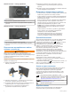
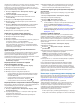
Если устройство не заряжается в автомобиле, возможно, необходимо заменить предохранитель, находящийся на конце автомобильного адаптера. 1 Чтобы разблокировать наконечник À, поверните его на 90 градусов против часовой стрелки. 2 3 4 5 СОВЕТ. для снятия наконечника можно использовать монету. Снимите наконечник, серебристую головку Á и предохранитель Â. Установите новый плавкий предохранитель с силой тока 1 A или 2 A. Поместите серебристую головку в наконечник.
Управление данными Покупка дополнительных карт Устройство можно использовать для хранения файлов. Благодаря разъему для карты памяти на устройстве можно хранить больше данных. ПРИМЕЧАНИЕ. это устройство не совместимо с операционными системами Windows 95, 98, Me, Windows NT и Mac OS 10.3 и более ранних версий. 1 Перейдите на страницу используемого устройства на ® Карты памяти сайте garmin.com. 2 Щелкните вкладку Карты. 3 Следуйте инструкциям на экране.
Указатель F Foursquare 9 G Garmin Express обновление программного обеспечения 1 регистрация устройства 1 GPS 2, 17 M myTrends, маршруты 6 U USB, отключение 17 А автомобильный кабель питания 2 адреса, поиск 9 аккумулятор, зарядка 2, 15 аксессуары 17 Б батарея зарядка 16 проблемы 16 увеличение времени работы 16 беспроводная камера 13, 14 Быстрый поиск 8 В вид карты 2-D 12 3-D 12 вид карты 2D 12 вид карты 3D 12 восстановление настроек 15 впереди по маршруту 11 настройка 11 Г Где я? 9, 10 геокэшинг 9 гро
Ш широта и долгота 9 Э экран, яркость 3 экранные кнопки 2 экстренные службы 9 Я язык голос 14 кнопки 14 яркость 3 Указатель 19
www.garmin.