
Owner's Manual
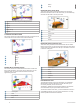
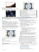
Table Of Contents
- Owner’s Manual
- Table of Contents
- Introduction
- Customizing the Chartplotter
- ActiveCaptain App
- Charts and 3D Chart Views
- Navigation Chart and Fishing Chart
- Premium Charts
- Automatic Identification System
- Chart View Settings
- Supported Maps
- Garmin Quickdraw Contours Mapping
- Mapping a Body of Water Using the Garmin Quickdraw Contours Feature
- Adding a Label to a Garmin Quickdraw Contours Map
- Garmin Quickdraw Community
- Garmin Quickdraw Contours Settings
- Navigation with a Chartplotter
- Basic Navigation Questions
- Destinations
- Waypoints
- Marking Your Present Location as a Waypoint
- Creating a Waypoint at a Different Location
- Marking an MOB Location
- Projecting a Waypoint
- Viewing a List of all Waypoints
- Editing a Saved Waypoint
- Moving a Saved Waypoint
- Browsing for and Navigating to a Saved Waypoint
- Deleting a Waypoint or an MOB
- Deleting All Waypoints
- Routes
- Auto Guidance
- Tracks
- Showing Tracks
- Setting the Color of the Active Track
- Saving the Active Track
- Viewing a List of Saved Tracks
- Editing a Saved Track
- Saving a Track as a Route
- Browsing for and Navigating a Recorded Track
- Deleting a Saved Track
- Deleting All Saved Tracks
- Retracing the Active Track
- Clearing the Active Track
- Managing the Track Log Memory During Recording
- Configuring the Recording Interval of the Track Log
- Boundaries
- Deleting All Saved Waypoints, Routes, and Tracks
- Sonar Fishfinder
- Stopping the Transmission of Sonar Signals
- Changing the Sonar View
- Traditional Sonar View
- Garmin ClearVü Sonar View
- SideVü Sonar View
- Panoptix Sonar Views
- Flasher View
- Selecting the Transducer Type
- Selecting a Sonar Source
- Creating a Waypoint on the Sonar Screen
- Pausing the Sonar Display
- Measuring Distance on the Sonar Screen
- Viewing Sonar History
- Sonar Sharing
- Adjusting the Level of Detail
- Adjusting the Color Intensity
- Sonar Recordings
- Traditional, Garmin ClearVü, and SideVü Sonar Setup
- Panoptix Sonar Setup
- Autopilot
- Sailing Features
- Gauges and Graphs
- Tide, Current, and Celestial Information
- Digital Selective Calling
- Media Player
- Opening the Media Player
- Selecting the Media Device and Source
- Playing Music
- Adjusting the Volume
- VHF Radio
- Radio
- DAB Playback
- SiriusXM® Satellite Radio
- Setting the Device Name
- Updating the Media Player Software
- Device Configuration
- Sharing and Managing User Data
- Connecting to a Garmin Device to Share User Data
- Selecting a File Type for Third-Party Waypoints and Routes
- Copying User Data from a Memory Card
- Copying User Data to a Memory Card
- Copying Built-In Maps to a Memory Card
- Copying Waypoints, Routes, and Tracks from HomePort to a Chartplotter
- Backing Up Data to a Computer
- Restoring Backup Data to a Chartplotter
- Saving System Information to a Memory Card
- Clearing Saved Data
- Appendix
- Index
- Quick Start Manual
- EchoMap Ultra 100/120 Series Installation Instructions
- EchoMap Ultra 100 Series Flush Mount Template
- Important Safety and Product Information

Configuring the Recording Interval of the Track Log
You can indicate the frequency at which the track plot is
recorded. Recording more frequent plots is more accurate but
fills the track log faster. The resolution interval is recommended
for the most efficient use of memory.
1
Select Nav Info > Tracks > Active Track Options > Record
Interval.
2
Select an option:
• To record the track based on a distance between points,
select Interval > Distance > Change, and enter the
distance.
• To record the track based on a time interval, select
Interval > Time > Change, and enter the time interval.
• To record the track plot based on a variance from your
course, select Interval > Resolution > Change, and enter
the maximum error allowed from the true course before
recording a track point. This is the recommended
recording option.
Boundaries
Boundaries allow you to avoid or remain in designated areas in
a body of water. You can set an alarm to alert you when you
enter or exit a boundary.
You can create boundary areas, lines, and circles using the
map. You can also convert saved tracks and routes into
boundary lines. You can create a boundary area using
waypoints by creating a route from the waypoints, and
converting the route into a boundary line.
You can select a boundary to act as the active boundary. You
can add the active boundary data to the data fields on the chart.
Creating a Boundary
1
Select Nav Info > Boundaries > New.
2
Select a boundary shape.
3
Follow the on-screen instructions.
Converting a Route to a Boundary
Before you can convert a route to a boundary, you must create
and save at least one route (Creating and Saving a Route,
page 13).
1
Select Nav Info > Routes.
2
Select a route.
3
Select Review > Edit Route > Save as Boundary.
Converting a Track to a Boundary
Before you can convert a track to a boundary, you must record
and save at least one track (Saving the Active Track, page 15).
1
Select Nav Info > Tracks > Saved Tracks.
2
Select a track.
3
Select Review > Edit Track > Save As > Save as
Boundary.
Editing a Boundary
1
Select Nav Info > Boundaries.
2
Select a boundary.
3
Select Review > Edit Boundary.
4
Select an option:
• To edit the appearance of the boundary on the chart,
select Display Options.
• To change the boundary lines or name, select Edit
Boundary.
• To edit the boundary alarm, select Alarm.
Setting a Boundary Alarm
Boundary alarms alert you when you are within a specified
distance of a set boundary. This can be helpful when attempting
to avoid certain areas or when you should be very alert in
certain areas, such as shipping lanes.
1
Select Nav Info > Boundaries.
2
Select a boundary.
3
Select Review > Alarm > On.
4
Select an option.
• To set an alarm for when your boat is a specified distance
from the boundary, select Warning Distance, enter a
distance, and select Done.
• To set an alarm when you enter the boundary, select Area
> Entering > Exiting.
• To set an alarm when you exit the boundary, select Area
> Exiting.
Deleting a Boundary
1
Select Nav Info > Boundaries.
2
Select a boundary.
3
Select Review > Edit Boundary > Delete.
Deleting All Saved Waypoints, Routes, and
Tracks
Select Nav Info > Manage Data > Clear User Data > All >
OK.
Sonar Fishfinder
When properly connected to a compatible transducer, your
chartplotter can be used as a fishfinder.
For more information about which transducer is best for your
needs, go to garmin.com/transducers.
Different sonar views can help you view the fish in the area. The
sonar views available vary depending on the type of transducer
and sounder module connected to the chartplotter. For example,
you can view certain Panoptix sonar screens only if you have a
compatible Panoptix transducer connected.
There are four basic styles of sonar views available: a full-
screen view, a split-screen view that combines two or more
views, a split-zoom view, and a split-frequency view that
displays two different frequencies. You can customize the
settings for each view in the screen. For example, if you are
viewing the split-frequency view, you can separately adjust the
gain for each frequency.
If you do not see an arrangement of sonar views to suit your
needs, you can create a custom combination screen (Creating a
New Combination Page with the ECHOMAP Ultra, page 2).
Stopping the Transmission of Sonar Signals
• To disable the active sonar, from the sonar screen, select
Menu > Sonar Transmit.
• To disable all sonar transmissions, press , and select
Disable Sonar.
Changing the Sonar View
1
From a combination screen with sonar, select Menu >
Configure Combination > Edit Combination.
2
Select the window to change.
3
Select a sonar view.
Traditional Sonar View
There are several full-screen views available, depending on the
transducer that is connected.
The full-screen Traditional sonar view shows a large image of
the sonar readings from a transducer. The range scale along the
16 Sonar Fishfinder