
Owner's Manual


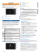
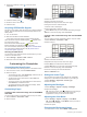
Table Of Contents
- EchoMap UHDOwner’s Manual
- Table of Contents
- Introduction
- Customizing the Chartplotter
- ActiveCaptain App
- Charts and 3D Chart Views
- Navigation Chart and Fishing Chart
- Zooming In and Out of the Chart
- Panning the Chart with the Keys
- Selecting an Item on the Map Using the Device Keys
- Chart Symbols
- Measuring a Distance on the Chart
- Creating a Waypoint on the Chart
- Navigating to a Point on the Chart
- Viewing Location and Object Information on a Chart
- Viewing Details about Navaids
- Heading Line and Angle Markers
- Premium Charts
- Automatic Identification System
- Chart Menu
- Supported Maps
- Navigation Chart and Fishing Chart
- Garmin Quickdraw Contours Mapping
- Mapping a Body of Water Using the Garmin Quickdraw Contours Feature
- Adding a Label to a Garmin Quickdraw Contours Map
- Garmin Quickdraw Community
- Garmin Quickdraw Contours Settings
- Navigation with a Chartplotter
- Basic Navigation Questions
- Destinations
- Waypoints
- Marking Your Present Location as a Waypoint
- Creating a Waypoint at a Different Location
- Marking an MOB Location
- Projecting a Waypoint
- Viewing a List of all Waypoints
- Editing a Saved Waypoint
- Moving a Saved Waypoint
- Browsing for and Navigating to a Saved Waypoint
- Deleting a Waypoint or an MOB
- Deleting All Waypoints
- Routes
- Auto Guidance
- Tracks
- Showing Tracks
- Setting the Color of the Active Track
- Saving the Active Track
- Viewing a List of Saved Tracks
- Editing a Saved Track
- Saving a Track as a Route
- Browsing for and Navigating a Recorded Track
- Deleting a Saved Track
- Deleting All Saved Tracks
- Retracing the Active Track
- Clearing the Active Track
- Managing the Track Log Memory During Recording
- Configuring the Recording Interval of the Track Log
- Boundaries
- Deleting All Saved Waypoints, Routes, and Tracks
- Sailing Features
- Sonar Fishfinder
- Stopping the Transmission of Sonar Signals
- Changing the Sonar View
- Traditional Sonar View
- Garmin ClearVü Sonar View
- SideVü Sonar View
- Panoptix Sonar Views
- Flasher View
- Selecting the Transducer Type
- Selecting a Sonar Source
- Creating a Waypoint on the Sonar Screen
- Pausing the Sonar Display
- Measuring Distance on the Sonar Screen
- Viewing Sonar History
- Sonar Sharing
- Adjusting the Level of Detail
- Adjusting the Color Intensity
- Sonar Recordings
- Traditional, Garmin ClearVü, and SideVü Sonar Setup
- Panoptix Sonar Setup
- Autopilot
- Force™ Trolling Motor Control
- Digital Selective Calling
- Gauges and Graphs
- Digital Switching
- Tide, Current, and Celestial Information
- Media Player
- Opening the Media Player
- Selecting the Media Source
- Playing Music
- Adjusting the Volume
- VHF Radio
- Radio
- DAB Playback
- SiriusXM Satellite Radio
- Setting the Device Name
- Updating the Media Player Software
- Device Configuration
- Sharing and Managing User Data
- Connecting to a Garmin Device to Share User Data
- Selecting a File Type for Third-Party Waypoints and Routes
- Copying User Data from a Memory Card
- Copying User Data to a Memory Card
- Copying Built-In Maps to a Memory Card
- Copying Waypoints, Routes, and Tracks from HomePort to a Chartplotter
- Backing Up Data to a Computer
- Restoring Backup Data to a Chartplotter
- Saving System Information to a Memory Card
- Clearing Saved Data
- Appendix
- Index
- EchoMap UHD Installation Instructions
- Printing a Mounting Template
- EchoMap UHD Template
- ClearVu Transducer Transom/Trolling Motor Mount Installation Instructions
- Important Safety and Product Information

If you are downloading an entire chart, you can use the Garmin
Express
™
app to download the map onto a memory card. The
Garmin Express app downloads large charts more quickly than
the ActiveCaptain app. For more information, go to garmin.com
/express.
NOTICE
Chart updates may require the app to download large files.
Regular data limits or charges from your internet service
provider apply. Contact your internet service provider for more
information about data limits or charges.
1
Connect the mobile device to the ECHOMAP UHD device
(Getting Started with the ActiveCaptain App, page 3).
2
When a chart update is available, and you have internet
access on your mobile device, select OneChart > My
Charts.
3
Select the map to update.
4
Select the area to download.
5
Select Download
The ActiveCaptain app downloads the update to the mobile
device. When you reconnect the app to the ECHOMAP UHD
device, the update is transferred to the device. After the
transfer is complete, the updated charts are available for use.
Charts and 3D Chart Views
The charts and 3D chart views that are available depend on the
map data and accessories used.
NOTE: 3D chart views are available with premium charts, in
some areas.
You can access the charts and 3D chart views by selecting
Charts.
Navigation Chart: Shows navigation data available on your pre-
loaded maps and from supplemental maps, if available. The
data includes buoys, lights, cables, depth soundings,
marinas, and tide stations in an overhead view.
Fishing Chart: Provides a detailed view of the bottom contours
and depth soundings on the chart. This chart removes
navigational data from the chart, provides detailed
bathymetric data, and enhances bottom contours for depth
recognition. This chart is best for offshore deep-sea fishing.
NOTE: The Fishing chart is available with premium charts, in
some areas.
Perspective 3D: Provides a view from above and behind the
boat (according to your course) and provides a visual
navigation aid. This view is helpful when navigating tricky
shoals, reefs, bridges, or channels, and is beneficial when
trying to identify entry and exit routes in unfamiliar harbors or
anchorages.
Mariner's Eye 3D: Shows a detailed, three-dimensional view
from above and behind the boat (according to your course)
and provides a visual navigation aid. This view is helpful
when navigating tricky shoals, reefs, bridges, or channels,
and when trying to identify entry and exit routes in unfamiliar
harbors or anchorages.
Fish Eye 3D: Provides an underwater view that visually
represents the sea floor according to the chart information.
When a sonar transducer is connected, suspended targets
(such as fish) are indicated by red, green, and yellow
spheres. Red indicates the largest targets and green
indicates the smallest.
Relief Shading: Provides high resolution elevation shading of
lakes and coastal waters. This chart can be helpful for fishing
and diving.
NOTE: The Relief Shading chart is available with premium
charts, in some areas.
Navigation Chart and Fishing Chart
NOTE: The Fishing chart is available with premium charts, in
some areas.
The Navigation Chart is optimized for navigation. You can plan a
course, view map information, and use the chart as a
navigational aid. To open the Navigation Chart, select Charts >
Navigation Chart.
The Fishing Chart provides a detailed view with more bottom
detail and fishing content. This chart is optimized for use when
fishing. To open the Fishing Chart, select Charts > Fishing
Chart.
Zooming In and Out of the Chart
The zoom level is indicated by the scale number at the bottom of
the chart. The bar under the scale number represents that
distance on the chart.
• To zoom out, select or pinch two fingers together on the
touchscreen.
• To zoom in, select or spread two fingers apart on the
touchscreen.
Panning the Chart with the Keys
You can move the chart to view an area other than your present
location.
1
From the chart, use the arrow keys.
2
Select BACK to stop panning and return the screen to your
present location.
NOTE: To pan from a combination screen, select SELECT.
Selecting an Item on the Map Using the Device Keys
1
From a chart or 3D chart view, select , , , or to move
the cursor.
2
Select SELECT.
Chart Symbols
This table contains some of the common symbols you might see
on the detailed charts.
Icon Description
Buoy
Information
Marine services
Tide station
Current station
Overhead photo available
Perspective photo available
Other features common to most charts include depth contour
lines, intertidal zones, spot soundings (as depicted on the
original paper chart), navigational aids and symbols,
obstructions, and cable areas.
Measuring a Distance on the Chart
1
From a chart, select a location.
2
Select Measure Distance.
4 Charts and 3D Chart Views