
Owner's Manual
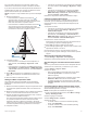
Table Of Contents
- Owner’s Manual
- Table of Contents
- Introduction
- Customizing the Chartplotter
- ActiveCaptain App
- Charts and 3D Chart Views
- Navigation Chart and Fishing Chart
- Premium Charts
- Automatic Identification System
- Chart Menu
- Supported Maps
- Garmin Quickdraw Contours Mapping
- Mapping a Body of Water Using the Garmin Quickdraw Contours Feature
- Adding a Label to a Garmin Quickdraw Contours Map
- Garmin Quickdraw Community
- Garmin Quickdraw Contours Settings
- Navigation with a Chartplotter
- Basic Navigation Questions
- Destinations
- Waypoints
- Marking Your Present Location as a Waypoint
- Creating a Waypoint at a Different Location
- Marking an MOB Location
- Projecting a Waypoint
- Viewing a List of all Waypoints
- Editing a Saved Waypoint
- Moving a Saved Waypoint
- Browsing for and Navigating to a Saved Waypoint
- Deleting a Waypoint or an MOB
- Deleting All Waypoints
- Routes
- Auto Guidance
- Tracks
- Showing Tracks
- Setting the Color of the Active Track
- Saving the Active Track
- Viewing a List of Saved Tracks
- Editing a Saved Track
- Saving a Track as a Route
- Browsing for and Navigating a Recorded Track
- Deleting a Saved Track
- Deleting All Saved Tracks
- Retracing the Active Track
- Clearing the Active Track
- Managing the Track Log Memory During Recording
- Configuring the Recording Interval of the Track Log
- Boundaries
- Deleting All Saved Waypoints, Tracks, Routes, and Boundaries
- Sonar Fishfinder
- Stopping the Transmission of Sonar Signals
- Changing the Sonar View
- Traditional Sonar View
- Garmin ClearVü Sonar View
- SideVü Sonar View
- Panoptix Sonar Views
- Flasher View
- Selecting the Transducer Type
- Selecting a Sonar Source
- Creating a Waypoint on the Sonar Screen
- Pausing the Sonar Display
- Measuring Distance on the Sonar Screen
- Viewing Sonar History
- Sonar Sharing
- Adjusting the Level of Detail
- Adjusting the Color Intensity
- Sonar Recordings
- Traditional, Garmin ClearVü, and SideVü Sonar Setup
- Panoptix Sonar Setup
- Autopilot
- Sailing Features
- Force® Trolling Motor Control
- Gauges and Graphs
- Digital Switching
- Tide, Current, and Celestial Information
- Digital Selective Calling
- Media Player
- Opening the Media Player
- Selecting the Media Source
- Playing Music
- Adjusting the Volume
- VHF Radio
- Radio
- DAB Playback
- SiriusXM® Satellite Radio
- Setting the Device Name
- Updating the Media Player Software
- Device Configuration
- Sharing and Managing User Data
- Appendix
- Index
- ECHOMAP Ultra Installation Instructions
- Transducer Installation Instructions
- Printing a Mounting Template
- ECHOMAP™ Ultra 120 Series Flush Mount Template
- Important Safety and Product Information

System Settings
Select Settings > System.
Display: Adjusts the backlight brightness and color scheme.
Beeper: Turns on and off the tone that sounds for alarms and
selections.
GPS: Provides information about the GPS satellite settings and
fix.
Auto Power Up: Turns on the device automatically when power
is applied (Turning On the Chartplotter Automatically,
page 35 ).
Auto Power Off: Turns off the device automatically after it has
been asleep for the selected length of time.
Keyboard Layout: Sets the arrangement of the keyboard to an
alphabetical or computer keyboard layout.
Language: Sets the on-screen text language.
Speed Sources: Sets the source of the speed data used to
calculate true wind speed or fuel economy. Water speed is
the speed reading from a water-speed sensor, and GPS
speed is calculated from your GPS position.
System Information: Provides information about the device and
the software version.
Simulator: Turns on the simulator and allows you to set the
speed and simulated location.
Regulatory Information: Displays device regulatory
information.
Display Settings
Not all options are available on all models.
Select Settings > System > Display.
Backlight: Sets the backlight level.
Color Mode: Sets the device to display day or night colors.
Screenshot Capture: Allows the device to save images of the
screen.
Menu Bar Display: Shows or automatically hides the menu bar
when it is not needed.
Background: Sets the device to display a background image or
color.
GPS Settings
NOTE: Not all options are available on all models.
Select Settings > System > GPS.
Skyview: Shows the relative position of GPS satellites in the
sky.
GLONASS: Turns on or off GLONASS data (Russia satellite
system). When the system is used in situations with poor sky
visibility, GLONASS data can be used in combination with
GPS to provide more accurate position information.
WAAS/EGNOS: Turns on or off WAAS data (in North America)
or EGNOS data (in Europe), which can provide more-
accurate GPS position information. When using WAAS or
EGNOS data, the device may take longer to acquire
satellites.
Galileo: Turns on or off Galileo data (European Union satellite
system). When the system is used in situations with poor sky
visibility, Galileo data can be used in combination with GPS
to provide more accurate position information.
Speed Filter: Averages the speed of your vessel over a short
period of time for smoother speed values.
Source: Allows you to select the preferred source for GPS data.
Viewing the Event Log
The event log shows a list of system events.
Select Settings > System > System Information > Event
Log.
Viewing System Software Information
You can view the software version, the basemap version, all
supplemental map information (if applicable), the software
version for an optional Garmin radar (if applicable), and the unit
ID number. You may need this information to update the system
software or to purchase additional map data information.
Select Settings > System > System Information >
Software Information.
Viewing E-label Regulatory and Compliance
Information
The label for this device is provided electronically. The e-label
may provide regulatory information, such as identification
numbers provided by the FCC or regional compliance markings,
as well as applicable product and licensing information. Not
available on all models.
1
Select Settings.
2
Select System.
3
Select Regulatory Information.
My Vessel Settings
NOTE: Some settings and options require additional charts or
hardware.
Select Settings > My Vessel.
Keel Offset: Offsets the surface reading for the depth of a keel,
making it possible to measure depth from the bottom of the
keel instead of from the transducer location (Setting the Keel
Offset, page 27).
Temp. Offset: Compensates for the water temperature reading
from a NMEA 0183 water-temperature sensor or a
temperature-capable transducer (Setting the Water
Temperature Offset, page 37).
Calibrate Water Speed: Calibrates the speed-sensing
transducer or sensor (Calibrating a Water-Speed Device,
page 37).
Vessel Type: Enables some chartplotter features based on the
boat type.
Fuel Capacity: Sets the combined fuel capacity of all the fuel
tanks on your vessel (Setting the Fuel Capacity of the Vessel,
page 30).
Fill Up All Tanks: Sets the tank levels to full (Synchronizing the
Fuel Data with the Actual Vessel Fuel, page 31).
Add Fuel to Boat: Allows you to enter the quantity of fuel you
added to your tank, when you did not entirely fill up the tank
(Synchronizing the Fuel Data with the Actual Vessel Fuel,
page 31).
Set Total Fuel Onboard: Sets the combined amount of fuel in
all the fuel tanks on your vessel (Synchronizing the Fuel Data
with the Actual Vessel Fuel, page 31).
Set Gauge Limits: Sets the upper and lower limits of various
gauges (Customizing Engine Gauge and Fuel Gauge Limits,
page 37).
CZone™: Sets the digital switching circuits.
SeaStar Instance: Sets the digital switching circuits.
Hull ID: Allows you to enter the Hull Identification Number
(HIN).The HIN might be permanently affixed to the upper
starboard side of the transom or outboard side.
Setting the Keel Offset
You can enter a keel offset to compensate the water depth
reading for the transducer installation location. This allows you
to view the depth of the water below the keel or the true depth of
the water, depending on your needs.
If you want to know the water depth below the keel or the lowest
point of your boat and the transducer is installed at the water
36 Device Configuration