
Owner's Manual
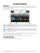

Table Of Contents
- ECHOMAP UHD2 Owner’s Manual
- Table of Contents
- Introduction
- Customizing the Chartplotter
- ActiveCaptain App
- Wireless Sharing
- Charts and 3D Chart Views
- Navigation Chart and Fishing Chart
- Chart Symbols
- Zooming In and Out of the Chart
- Panning the Chart with the Keys
- Selecting an Item on the Map Using the Device Keys
- Measuring a Distance on the Chart
- Creating a Waypoint on the Chart
- Viewing Location and Object Information on a Chart
- Viewing Details about Navaids
- Navigating to a Point on the Chart
- Premium Charts
- Chart Menu
- Supported Maps
- Navigation Chart and Fishing Chart
- Garmin Quickdraw Contours Mapping
- Mapping a Body of Water Using the Garmin Quickdraw Contours Feature
- Adding a Label to a Garmin Quickdraw Contours Map
- Garmin Quickdraw Community
- Garmin Quickdraw Contours Settings
- Navigation with a Chartplotter
- Basic Navigation Questions
- Route Color Coding
- Destinations
- Waypoints
- Marking Your Present Location as a Waypoint
- Creating a Waypoint at a Different Location
- Marking a Man Overboard (MOB) Location
- Projecting a Waypoint
- Viewing a List of all Waypoints
- Editing a Saved Waypoint
- Moving a Saved Waypoint
- Browsing for and Navigating to a Saved Waypoint
- Deleting a Waypoint or an MOB
- Deleting All Waypoints
- Routes
- Creating and Navigating a Route From Your Present Location
- Creating and Saving a Route
- Viewing a List of Routes and Auto Guidance Paths
- Editing a Saved Route
- Finding and Navigating a Saved Route
- Browsing for and Navigating Parallel to a Saved Route
- Initiating a Search Pattern
- Deleting a Saved Route
- Deleting All Saved Routes
- Auto Guidance
- Tracks
- Showing Tracks
- Setting the Color of the Active Track
- Saving the Active Track
- Viewing a List of Saved Tracks
- Editing a Saved Track
- Saving a Track as a Route
- Browsing for and Navigating a Recorded Track
- Deleting a Saved Track
- Deleting All Saved Tracks
- Retracing the Active Track
- Clearing the Active Track
- Managing the Track Log Memory During Recording
- Configuring the Recording Interval of the Track Log
- Boundaries
- Deleting All Saved Waypoints, Tracks, Routes, and Boundaries
- Sonar Fishfinder
- Stopping the Transmission of Sonar Signals
- Traditional Sonar View
- Garmin ClearVü Sonar View
- Flasher View
- Selecting the Transducer Type
- Selecting a Sonar Source
- Creating a Waypoint on the Sonar Screen
- Pausing the Sonar Display
- Viewing Sonar History
- Adjusting the Level of Detail
- Adjusting the Color Intensity
- Sonar Setup
- Gauges and Graphs
- Warning Manager
- Device Configuration
- Sharing and Managing User Data
- Appendix
- ECHOMAP UHD2 Installation Instructions
- Trolling Motor Mount Installation Instructions
- Printing a Mounting Template
- ECHOMAP UHD2 Template
- Important Safety and Product Information

Updating Charts with ActiveCaptain
You can use the ActiveCaptain app to download and transfer the latest chart updates for your device. To save
space on your mobile device, space on the ActiveCaptain card, and download time, consider using the
ActiveCaptain app to download only the areas of the chart you need.
If you are downloading an entire chart, you can use the Garmin Express
™
app to download the map onto a
memory card (Updating Your Charts Using the Garmin Express App, page 64). The Garmin Express app
downloads large charts more quickly than the ActiveCaptain app.
NOTICE
Chart updates may require the app to download large files. Regular data limits or charges from your internet
service provider apply. Contact your internet service provider for more information about data limits or charges.
1 Connect the mobile device to the ECHOMAP UHD2 device (Getting Started with the ActiveCaptain App,
page 10).
2 When a chart update is available, and you have internet access on your mobile device, select OneChart > My
Charts.
3 Select the map to update.
4 Select the area to download.
5 Select Download.
The ActiveCaptain app downloads the update to the mobile device. When you reconnect the app to the
ECHOMAP UHD2 device, the update is transferred to the device. After the transfer is complete, the updated
charts are available for use.
Chart Subscriptions
A chart subscription allows you to access the latest chart updates and additional content using the
ActiveCaptain mobile app or the Garmin Express desktop app. You can download updated charts and content
each day.
You can purchase chart subscriptions in a variety of ways.
• Digital purchase in the ActiveCaptain mobile app
• Digital purchase on garmin.com
• Physical chart card purchase at a retail location or through garmin.com or navionics.com
• Physical chart upgrade card purchase at a retail location (for upgrading the built-in charts)
Purchasing a Chart Subscription with ActiveCaptain
1 Connect your mobile device to the internet and open the ActiveCaptain app.
2 Select Chart > > My Charts > Add a Subscription.
3 Select a chart.
4 Select Subscribe Now.
NOTE: It might take a few hours to display the new subscription.
Activating the Chart Subscription Card
If you purchased a chart subscription memory card, you must activate it before you can use it.
1 Insert the purchased chart subscription card into a memory card slot on the chartplotter.
2 Open the ActiveCaptain app on your mobile device, and connect it to the internet.
3 Disconnect your mobile device from the internet, and connect it to the chartplotter (Getting Started with the
ActiveCaptain App, page 10).
The ActiveCaptain app activates the subscription automatically after it connects to the internet and then to
the chartplotter. The ActiveCaptain app displays the new subscription in the My Charts list.
NOTE: It might take a few hours to display the new subscription.
ActiveCaptain App 11