
Cockpit Reference Guide

Garmin G1000H Cockpit Reference Guide for the AgustaWestland AW119Kx
190-01515-00 Rev. B
49
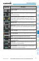
Hazard Avoidance
Flight
Instruments EIS
Com/Nav/
XPDR GPS Nav
Flight
Planning Procedures
Hazard
Avoidance
Additional
Features
Abnormal
Operation Annun/Alerts Appendix Index
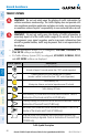
NOTE: If HTerrain-SVS alerts are inhibited when the Final Approach Fix is
the active waypoint in a GPS SBAS approach, a LOW ALT annunciation may
appear on the PFD next to the altimeter if the current aircraft altitude is at
least 164 feet below the prescribed altitude at the Final Approach Fix.
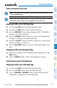
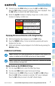
Displaying Terrain and Obstacles on the Navigation Map
1)
With the Navigation Map displayed, press the
MAP
Softkey.
2)
Press the
TERRAIN
Softkey. Terrain and obstacle proximity will now be
displayed on the map.
3)
Terrain and obstacles may be displayed in the Profile View by pressing the
PROFILE Softkey.
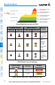
TERRAIN AWARENESS & WARNING SYSTEM (HTAWS) DISPLAY
WARNING: Do not use HTAWS information for primary terrain avoidance.
HTAWS is intended only to enhance situational awareness.
NOTE: The data contained in the HTAWS databases comes from government
agencies. Garmin accurately processes and cross-validates the data but cannot
guarantee the accuracy and completeness of the data.
NOTE: Terrain data is not displayed when the aircraft is outside the installed
terrain database coverage area.
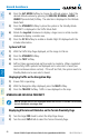
Displaying the HTAWS Page:
1)
Turn the large
FMS
Knob to select the Map Page Group.
2)
Turn the small
FMS
Knob to select HTAWS Page.
Changing the HTAWS Page view:
1)
Press the
VIEW
Softkey.
2)
Press the 360 or ARC Softkey to select the desired view.
Or:
1)
Press the MENU Key.
2)
Select ‘View Arc’ or ‘View 360º’ and press the ENT Key to change the view.