user’s guide BlueChart ® marine cartography
© Copyright 2006, 2007 Garmin Ltd. or its subsidiaries Garmin International, Inc. 1200 East 151st Street, Olathe, Kansas 66062, USA Tel: 913/397.8200 or 800/800.1020, Fax: 913/397.8282 e-mail: cartography@garmin.com Garmin (Europe) Ltd. Liberty House Hounsdown Business Park, Southampton, Hampshire, SO40 9RB UK Tel. +44 (0) 870.8501241 (outside the UK) 0808 2380000 (within the UK) Fax +44 (0) 870.8501251 email: cartography.europe@garmin.com Garmin Corporation No.
Portions of BlueChart data may be subject to the following copyrights and notices: © 2005 MapTech, Inc. The chart information in this product is reproduced, in whole or part, with the permission of the following national hydrographic offices and other organizations: Australian Hydrographic Service; Editrice Incontri Nautici (Bolina); Hydrographic Institute of the Republic of Croatia; Kort & Matrikelstyrelsen, Denmark, license no. G.
WARNING:No national hydrographic office has verified the information in this product or quality assured it, and none accept liability for the accuracy of reproduction or any modifications made thereafter. No national hydrographic office makes any warranties or representations, express or implied, with respect to this product.
Introduction > Overview Introduction BlueChart® g2 is Garmin’s exclusive line of highly-detailed marine cartography. BlueChart g2 cartography features smoother layering and better integration of map graphics for faster redraws and more cohesive panning, scrolling, and zooming. Overview Blue Chart g2 features richer colors and shading for easier interpretation and improved visibility.
Introduction > Introduction Additional BlueChart g2 enhancements include: • Shaded depth contours • Mariner’s eye view map perspective • Port plans and navigationally significant photos • Improved IALA symbology • Intertidal zones with spot soundings • Navaids with view range and coverage • Data on tides and currents • Coastal roads, marinas, points of interest • Wrecks, restricted areas, anchorages • Shoals, spoilage, and more Like all BlueChart cartography, BlueChart g2 cartography is styled to match the
Introduction > Table of Contents Table of Contents Introduction....................................................................................................... i Overview...................................................................................................................i Warning...................................................................................................................iv Getting Started............................................................................
Introduction > Warning Warning Failure to avoid the following potentially hazardous situations could result in an accident or collision resulting in death or serious injury. When navigating, carefully compare BlueChart g2 information to all available navigation sources, including information from visual sightings, and paper maps. For safety, always resolve any discrepancies or questions before continuing navigation.
Getting Started > Getting Started Getting Started Garmin BlueChart g2 preprogrammed data cards are available in a region-by-region format. To find out what region or regions will work best for you, please consult your local Garmin marine dealer or visit the Garmin Web site at www.garmin.com. From the Maps & Charts section of the Garmin Web site, you can view the listing of available BlueCharts, the areas of coverage, and the paper charts contained within each card.
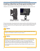
Getting Started> Installing a BlueChart g2 Preprogrammed Data Card Installing a BlueChart g2 Preprogrammed Data Card Look for a compartment door or rubber weather cap on the bottom (or front for large chartplotters) of your Garmin unit. Beneath the door or weather cap is a slot for a data card. Data Card Slot on a GPSMAP 3206/3210 Data Card Slot on a GPSMAP 492/498 To insert the card, place the card into the slot (connector end first) with the label facing toward the front of the Garmin unit.
Viewing BlueChart g2 > Understanding BlueChart g2 Data Viewing BlueChart g2 Information BlueChart g2 technology for the coastal United States (including Alaska and Hawaii) is preloaded on Garmin’s GPSMAP 492 and GPSMAP 498 chartplotters, as well as its large- display GPSMAP 2200 series and GPSMAP 3200 series of chartplotters. To access additional BlueChart g2 functionality, you can purchase preprogrammed data cards.
Viewing BlueChart g2 > Understanding BlueChart g2 Data Other features common to most BlueChart g2 data include: • Depth contour lines (with deep water represented in white) • Inter-tidal zones • Spot soundings, as depicted on the original paper chart • Navigational aids and symbols • Obstructions and cable areas Wreck Information Buoy Marina Services Yacht Harbor Tide Station Garmin includes charts and symbols shown on NOAA chart 1, and marine services from other sources.
Viewing BlueChart g2 > Accessing Additional Object Information Accessing Additional Object Information You can view additional information about many of the objects you see on a BlueChart g2 map. To access additional object information when using a Garmin unit: Place the unit’s map pointer on an object, and press ENTER. A window appears with additional information for the selected object.
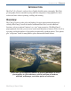
Viewing BlueChart g2 > Accessing Additional Object Information Viewing Photos On Garmin BlueChart g2 preprogrammed data cards, navigationally significant aerial photographs are available for most ports and marinas. These photos can help you familiarize yourself with your surroundings. The camera icon ( ) indicates a photo is available. There are usually two or three photos for each marina. To view a photo: Place the unit’s map pointer on a camera icon ( ), and press ENTER.
Viewing BlueChart g2 > Accessing Additional Object Information Accessing Paper-Chart-Specific Information BlueChart g2 cartography provides paper-chart-specific information, such as chart publisher, print date, edition date, NTM (Notice to Mariners), correction date, and scale. Additional notes are available for the paper charts. To view paper-chart-specific information on your Garmin unit: Place the unit’s cursor on an open area of the chart, and press ENTER.
Viewing BlueChart g2 > Understanding the Differences Between Charts Understanding the Differences Between Electronic and Paper Charts Occasionally, boaters notice that the BlueChart g2 data does not duplicate a particular feature shown on the paper chart they are using. Garmin uses the best charts available and carefully turns the paper charts into a digital format for display on an electronic screen. If there are errors, omissions, or discrepancies on paper, they might occur electronically too.
Viewing BlueChart g2 > Viewing Tide and Current Information Viewing Tide and Current Information Using BlueChart g2 cartography, you can access tide information from more than 3,000 Tide Prediction Stations across the world. You can also access current information from Current Stations around the United States coastline, including Alaska and Hawaii as well as western Canada and several Caribbean islands.
Appendix > Caring for and Reading the ID Code on a g2 Card Appendix Caring for Your BlueChart g2 Data Card BlueChart g2 cards are not waterproof. When you are not using the card, keep it in the original packaging for safekeeping, and store it away from exposure to sun and rain. BlueChart g2 cards are susceptible to damage from static electricity. In low humidity environments, you should ground yourself on a large metal object before handling the card.
Appendix > Warranty, Registration, and Contact Information Warranty Information Examine your preprogrammed BlueChart g2 card for damage immediately upon receipt. Garmin accepts returned cards within 10 days of the purchase date, if the card is found to be defective. Product Registration Help us better support you by completing our online registration today! By registering your purchase you are assured of notification of product updates or information about new products.
Appendix > Index A additional object information 5 airport/seaplane base 3 anchorage berth 3 anchoring prohibited 3 B beacon 3 building 3 buoy 3, 4 C camera icon 6 caring for 10 chart errors 8 church 3 contact 11 currents 9 current station 3, 9 D dangerous rock 3 data card 2, 3, 6, 10, 11, 13. See Garmin data card E explosive 3 exposed rock 3 exposed wreck 3, 4 F fishing harbor 3 fishing prohibited 3 G Garmin data card.
BlueChart® g2 Data Card Order Form If you want to trade-in or update BlueChart g2, contact Garmin Product Support at: 800/800.1020.
For the latest free software updates (excluding map data) throughout the life of your Garmin products, visit the Garmin web site at www.garmin.com. © Copyright 2006, 2007 Garmin Ltd. or its subsidiaries Garmin International, Inc. 1200 East 151st Street, Olathe, Kansas 66062, USA Garmin (Europe) Ltd. Liberty House, Hounsdown Business Park, Southampton, Hampshire, SO40 9RB UK Garmin Corporation No. 68, Jangshu 2nd Road, Shijr, Taipei County, Taiwan www.garmin.com Part Number 190-00656-00 Rev.