
User manual


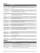
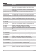
Table Of Contents
- Table of Contents
- Introduction
- Clocks
- Activities and Apps
- Starting an Activity
- Stopping an Activity
- Running
- Swimming
- Multisport
- Indoor Activities
- Climbing Sports
- Starting an Expedition
- Going Hunting
- Marine Activities
- Skiing and Winter Sports
- Golfing
- Jumpmaster
- Customizing Activities and Apps
- Training
- Training for a Race Event
- Workouts
- PacePro Training
- Power Guide
- Segments
- Using Virtual Partner®
- Setting a Training Target
- Racing a Previous Activity
- History
- Appearance
- Watch Face Settings
- Glances
- Viewing the Glance Loop
- Customizing the Glance Loop
- Body Battery
- Performance Measurements
- Training Status
- Adding a Stock
- Controls
- Morning Report
- Sensors and Accessories
- Map
- Music
- Connectivity
- User Profile
- Safety and Tracking Features
- Health and Wellness Settings
- Navigation
- Power Manager Settings
- System Settings
- Device Information
- Troubleshooting
- Product Updates
- Getting More Information
- My device is in the wrong language
- Is my phone compatible with my watch?
- My phone will not connect to the watch
- Can I use my Bluetooth sensor with my watch?
- My headphones will not connect to the watch
- My music cuts out or my headphones won't stay connected
- Restarting Your Watch
- Resetting All Default Settings
- Tips for Maximizing the Battery Life
- Acquiring Satellite Signals
- The temperature reading is not accurate
- Activity Tracking
- Appendix

Muscle Oxygen Fields
Name Description
Muscle O2 Saturation % The estimated muscle oxygen saturation percentage for the current activity.
Total Hemoglobin The estimated total hemoglobin concentration in the muscle.
Navigation Fields
Name Description
Bearing
The direction from your current location to a destination. You must be navigating for this
data to appear.
Course
The direction from your starting location to a destination. Course can be viewed as a
planned or set route. You must be navigating for this data to appear.
Destination
Location
The position of your final destination.
Destination
Waypoint
The last point on the route to the destination. You must be navigating for this data to
appear.
Distance Remaining
The remaining distance to the final destination. You must be navigating for this data to
appear.
Distance To Next
The remaining distance to the next waypoint on the route. You must be navigating for
this data to appear.
Estimated Total
Distance
The estimated distance from the start to the final destination. You must be navigating
for this data to appear.
ETA
The estimated time of day when you will reach the final destination (adjusted to the local
time of the destination). You must be navigating for this data to appear.
ETA at Next
The estimated time of day when you will reach the next waypoint on the route (adjusted
to the local time of the waypoint). You must be navigating for this data to appear.
ETE
The estimated time remaining until you reach the final destination. You must be navi
gating for this data to appear.
Glide Ratio to Desti
nation
The glide ratio required to descend from your current position to the destination
elevation. You must be navigating for this data to appear.
Lat/Lon
The current position in latitude and longitude regardless of the selected position format
setting.
Location The current position using the selected position format setting.
Next Fork The distance to the next fork on a trail. You must be navigating for this data to appear.
Next Waypoint The next point on the route. You must be navigating for this data to appear.
Off Course
The distance to the left or right by which you have strayed from the original path of
travel. You must be navigating for this data to appear.
Time to Next
The estimated time remaining before you reach the next waypoint in the route. You must
be navigating for this data to appear.
Velocity Made Good
The speed at which you are closing on a destination along a route. You must be navi
gating for this data to appear.
Appendix 125