
Operation Manual


Cleaning the Screen
NOTICE
Cleaners containing ammonia will harm the anti-reflective
coating.
The device is coated with a special anti-reflective coating which
is very sensitive to waxes and abrasive cleaners.
1
Apply an eyeglass lens cleaner specified as safe for anti-
reflective coatings to the cloth.
2
Gently wipe the screen with a soft, clean, lint-free cloth.
Viewing Images on a Memory card
You can view images that are saved on a memory card. You
can view .jpg, .png, and .bmp files.
1
Insert a memory card with image files into the card slot.
2
Select NAV INFO > Image Viewer.
3
Select the folder containing the images.
4
Wait a few seconds for the thumbnail images to load.
5
Select an image.
6
Use the arrows to scroll through the images.
7
If necessary, select MENU > Start Slideshow.
Screenshots
You can capture a screenshot of any screen shown on your
chartplotter as a bitmap (.bmp) file. You can transfer the
screenshot to your computer. You can also view the screenshot
in the image viewer (
Viewing Images on a Memory card,
page 47)
.
Capturing Screenshots
1
Insert a memory card into the card slot.
2
Select Settings > Preferences > Screenshot Capture >
On.
3
Go to a screen you want to capture.
4
Hold
HOME for at least six seconds.
Copying Screenshots to a Computer
1
Remove the memory card from the chartplotter, and insert it
into a card reader that is attached to a computer.
2
From
Windows
®
Explorer, open the Garmin\scrn folder on the
memory card.
3
Copy a .bmp file from the card and paste it to any location on
the computer.
Troubleshooting
My device will not acquire GPS signals
If the device is not acquiring satellite signals, there could be a
few causes. If the device has moved a large distance since the
last time it has acquired satellites or has been turned off for
longer than a few weeks or months, the device may not be able
to acquire the satellites correctly.
• Ensure the device is using the latest software. If not, update
the device software (Software Update,
page
1).
• Make sure the device has a clear view of the sky so the
antenna can receive the GPS signal. If it is mounted inside of
a cabin, it should be close to a window so it can receive the
GPS signal.
• If the device is using an external GPS antenna, make sure
the antenna is connected to the chartplotter or the NMEA
network.
• If the device has more than one GPS antenna source, select
a different source
(
Selecting the GPS Source, page 2)
.
My device will not turn on or keeps turning off
Devices erratically turning off or not turning on could indicate an
issue with the power supplied to the device. Check these items
to attempt to troubleshoot the cause of the power issue.
• Make sure the power source is generating power.
You can check this several ways. For example, you can
check whether other devices powered by the source are
functioning.
• Check the fuse in the power cable.
The fuse should be located in a holder that is part of the red
wire of the power cable. Check that the proper size fuse is
installed. Refer to the label on the cable or the installation
instructions for the exact fuse size needed. Check the fuse to
make sure there is still a connection inside of the fuse. You
can test the fuse using a multimeter. If the fuse is good, the
multimeter reads 0 ohm.
• Check to make sure the device is receiving is at least 10 V,
but 12 V is recommended.
To check the voltage, measure the female power and ground
sockets of the power cable for DC voltage. If the voltage is
less than 10 V, the device will not turn on.
• If the device is receiving enough power but does not turn on,
contact Garmin product support at support.garmin.com.
My device is not creating waypoints in the correct
location
You can manually enter a waypoint location to transfer and
share data from one device to the next. If you have manually
entered a waypoint using coordinates, and the location of the
point does not appear where the point should be, the map
datum and position format of the device may not match the map
datum and position format originally used to mark the waypoint.
Position format is the way in which the GPS receiver's position
appears on the screen. This is commonly displayed as latitude/
longitude in degrees and minutes, with options for degrees,
minutes and second, degrees only, or one of several grid
formats.
Map datum is a math model which depicts a part of the surface
of the earth. Latitude and longitude lines on a paper map are
referenced to a specific map datum.
1
Find out which map datum and position format was used
when the original waypoint was created.
If the original waypoint was taken from a map, there should
be a legend on the map that lists the map datum and position
format used to create that map. Most often this is found near
the map key.
2
Select Settings
> Preferences > Units
.
3
Select the correct map datum and position format settings.
4
Create the waypoint again.
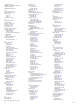
NMEA 2000 PGN Information
Type PGN Description
Transmit and receive 059392 ISO acknowledgment
059904 ISO request
060928 ISO address claim
126208 NMEA
: Command, request, and
acknowledge group function
126996 Product information
127250 Vessel heading
128259 Speed: Water referenced
128267 Water depth
129539 GNSS DOPs
129799 Radio frequency, mode, and power
130306 Wind data
Appendix 47