
Pilot's Guide

190-00663-03 Rev. A
Garmin G1000 Pilot’s Guide for the Beechcraft C90A/GT/GTi
245
FLIGHT MANAGEMENT
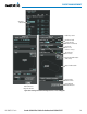
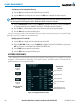
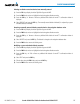
White Text Cyan Text Cyan Subdued Text
Large
Text
Altitude calculated by the system
estimating the altitude of the aircraft as
it passes over the navigation point. This
altitude is provided as a reference and is
not designated to be used in determining
vertical speed and deviation guidance.
Altitude has been entered manually.
Altitude is designated for use in giving
vertical speed and deviation guidance.
Altitude does not match the published
altitude in navigation database or no
published altitude exists.
The system cannot use this
altitude in determining vertical
speed and deviation guidance
because of an invalid constraint
condition.
Small
Text
Altitude is not designated to be used in
determining vertical speed and deviation
guidance. Altitude has been retrieved
from the navigation database and is
provided as a reference.
Altitude is designated for use in giving
vertical speed and deviation guidance.
Altitude has been retrieved from the
navigation database or has been entered
manually and matches a published
altitude in the navigation database.
The system cannot use this
altitude in determining vertical
speed and deviation guidance
because of an invalid constraint
condition.
Table 5-8 Altitude Constraint Size and Color Coding
Altitudes associated with arrival and approach procedures are not “auto-designated”. This means the system
does not automatically use the altitudes loaded with the arrival or approach for giving vertical speed and
deviation guidance. Note that these altitudes are displayed as white text up to, but not including, the FAF.
The FAF is always a “reference only” altitude and cannot be designated, unless the selected approach does not
provide vertical guidance. In this case, the FAF altitude can be designated.
Altitudes that are not designated for use in vertical guidance can be “designated” using the ENT Key. The
altitude is now displayed as cyan text and is used to give vertical guidance. Other displayed altitudes may
change due to re-calculations or be rendered invalid as a result of manually changing an altitude to a designated
altitude.
Altitudes that have been designated for use in vertical guidance can be “un-designated” using the CLR Key.
The altitude is now displayed only as a reference. It is not used to give vertical guidance. Other displayed
altitudes may change due to re-calculations or be rendered invalid as a result of manually changing an altitude
to a non-designated altitude.
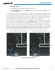
Designating an altitude from the navigation database to be used for vertical guidance:
1) Press the FPL Key to display the Active Flight Plan Page on the MFD.
2) Press the FMS Knob, and turn to highlight the desired waypoint altitude.
3) Press the ENT Key. The altitude is now shown in cyan, indicating it is usable for vertical guidance.
Designating an altitude not from the navigation database value to be used for vertical guidance:
1) Press the FPL Key to display the Active Flight Plan Page on the MFD.
2) Press the FMS Knob, and turn to highlight the desired waypoint altitude.
3) Turn the small FMS Knob to enter editing mode.
4) Press the ENT Key. The altitude is now shown in cyan, indicating it is usable for vertical guidance.