
Pilot's Guide

Garmin G1000 Pilot’s Guide for the Beechcraft C90A/GT/GTi
190-00663-03 Rev. A318
HAZARD AVOIDANCE
Displaying NEXRAD weather information:
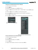
1) Select the MAP Softkey (for the PFD Inset Map, press the INSET Softkey). This step is not necessary on the
Weather Data Link (XM) Page.
2) Select the NEXRAD Softkey.
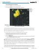
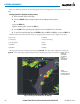
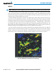
Composite data from all the NEXRAD radar sites in the United States is shown. This data is composed of
the maximum reflectivity from the individual radar sweeps. The display of the information is color-coded
to indicate the weather severity level. All weather product legends can be viewed on the Weather Data Link
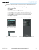
(XM) Page. For the NEXRAD legend (Figure 6-11), select the
LEGEND
Softkey when NEXRAD is selected for
display.
No Radar Coverage
Figure 6-11 NEXRAD Data with Legend
The display of radar coverage is always active when either NEXRAD or Echo Tops is selected. Areas where
NEXRAD radar coverage and Echo Tops information is not currently available or is not being collected are
indicated in gray shade of purple.
ReFlectivity
Reflectivity is the amount of transmitted power returned to the radar receiver. Colors on the NEXRAD
display are directly correlative to the level of detected reflectivity. Reflectivity as it relates to hazardous
weather can be very complex.
The role of radar is essentially to detect moisture in the atmosphere. Simply put, certain types of weather
reflect radar better than others. The intensity of a radar reflection is not necessarily an indication of the
weather hazard level. For instance, wet hail returns a strong radar reflection, while dry hail does not. Both
wet and dry hail can be extremely hazardous.
The different NEXRAD echo intensities are measured in decibels (dB) relative to reflectivity (Z). NEXRAD
measures the radar reflectivity ratio, or the energy reflected
back to
the radar receiver (
designated by the
letter Z)
. The value of Z increases as the returned signal strength increases.