
Pilot's Guide

Garmin G1000 Pilot’s Guide for the Beechcraft C90A/GT/GTi
190-00663-03 Rev. A324
HAZARD AVOIDANCE
CELL MOVEMENT
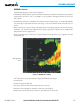
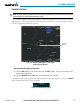
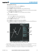
Cell Movement data (Figure 6-20) shows the location and movement of storm cells as identified by the
ground-based system. Cells are represented by yellow squares, with direction of movement indicated with
short, orange arrows.
Figure 6-20 Cell Movement Data
Storm
Cells
On most applicable maps, Cell Movement data is selected for display along with NEXRAD. On the Weather
Data Link (XM) Page, Cell Movement data can be selected independently.
Displaying Cell Movement information:
1) Select the MAP Softkey (for the PFD Inset Map, press the INSET Softkey). This step is not necessary on the
Weather Data Link (XM) Page.
2) Select the NEXRAD Softkey (CEL MOV Softkey on the XM Weather Data Link (XM) Page). For Cell Movement
to be displayed on maps other than the Weather Data Link (XM) Page, Cell Movement must be turned on in the
Navigation Map Setup Menu (see “Setting Up XM Satellite Weather”).
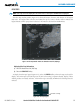
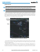
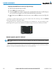
To display the Cell Movement legend on the Weather Data Link (XM) Page, (Figure 6-21), select the
LEGEND
Softkey when Cell Movement is selected for display.
Figure 6-21 Cell Movement Legend