
Cockpit Reference Guide


Garmin G1000 Cockpit Reference Guide for the Beechcraft 300/B300 Series
190-01344-00 Rev. B
46
Hazard Avoidance
Flight
Instruments
Nav/Com/
XPDR/AudioAFCSGPS Nav
Flight
PlanningProcedures
Hazard
Avoidance
Additional
FeaturesAnnun/AlertsAppendixIndex
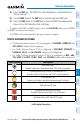
The following may cause abnormalities in displayed radar images:
• Groundclutter
• Strobesandspuriousradardata
• Sunstrobes(whentheradarantennapointsdirectlyatthesun)
• Interferencefrombuildingsormountains,whichmaycauseshadows
• Metallicdustfrommilitaryaircraft,whichcancausealterationsinradarscans
Infrared Satellite
Infrared Satellite (IR SAT) data depicts cloud top temperatures from satellite imagery.
Brighter cloud top colors indicate cooler temperatures occurring at higher altitudes.
Displaying clouD tops information
1)
Select the GFDS Weather Data Link Page.
2)
Select the IR SAT Softkey.
To display the Infrared Satellite legend, select the LEGEND Softkey when Infrared
Satellite data is selected for display.
Datalink Lightning
Lightning data shows the approximate location of cloud-to-ground lightning strikes.
A strike icon represents a strike that has occurred within a two-kilometer region.
Neither cloud-to-cloud nor the exact location of the lightning strike is displayed.
If the aircraft is also equipped with the L-3 WX-500 Stormscope
®
, only one lightning
product may be enabled for display at a time.
Displaying Datalink lightning information
1)
Select the MAP Softkey (for the PFD Inset Map, select the INSET Softkey).
This step is not necessary on the GFDS Weather Data Link Page.
2)
Select the DL LTNG Softkey.
To display the Datalink Lightning legend on the Weather Data Link Page, select the
LEGEND Softkey when Datalink Lightning is selected for display.