
Cockpit Reference Guide


Garmin G1000 Cockpit Reference Guide for the Beechcraft 300/B300 Series
190-01344-00 Rev. B
Appendix
120
Flight
Instruments
Nav/Com/
XPDR/AudioAFCSGPS Nav
Flight
PlanningProcedures
Hazard
Avoidance
Additional
FeaturesAnnun/AlertsAppendixIndex
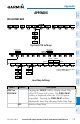
Level 1 Level 2 Description
DCLTR (3)
Selects desired amount of map detail; cycles
through declutter levels:
DCLTR (No Declutter): All map features visible
DCLTR-1: Declutters land data
DCLTR-2: Declutters land and SUA data
DCLTR-3: Removes everything except the active
flight plan
WX LGND
Displays icon and age on the Inset Map for the
selected weather products (optional)
TRAFFIC
Displays traffic information on Inset Map
TOPO
Displays topographical data (e.g., coastlines,
terrain, rivers, lakes) and elevation scale on Inset
Map
TERRAIN
Displays terrain information on Inset Map
STRMSCP
Press to display the Stormscope lightning data
on the Inset Map (within a 200 nm radius of the
aircraft)
NEXRAD
or
PRECIP
Displays NEXRAD weather and coverage
information on Inset Map (optional)
Displays Worldwide Weather precipitation on
Inset Map (optional)
XM LTNG
or
DL LTNG
Displays XM lightning information on Inset Map
(optional)
Displays Worldwide Weather lightning
information on Inset Map (optional)
METAR
Displays METAR flags on airport symbols shown on
the Inset Map (optional)