
Pilot's Guide

190-00663-02 Rev. B
Garmin G1000 Pilot’s Guide for the Hawker Beechcraft C90A/GT/GTi
323
HAZARD AVOIDANCE
ICING (CIP & SLD)
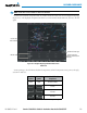
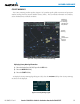
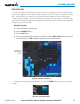
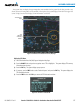
CurrentIcingProduct(CIP)information(Figure6-41)showsagraphicalviewoftheicingenvironment.
Icingseverityisdisplayedinfourcategories:light,moderate, severe,andextreme(notspecictoaircraft
type).TheCIPproductisnotaforecast,butapresentationoftheconditionsatthetimeoftheanalysis.
SupercooledLargeDroplet (SLD) icing conditions arecharacterized by the presenceofrelatively large,
supercooledwaterdropletsindicativeoffreezingdrizzleandfreezingrainaloft.SLDthreatareasaredepicted
asmagentadotsovertheCIPcolors.
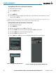
Displaying Icing data:
1) Select the Weather Data Link (XM) Page.
2) Select the
MORE WX
Softkey.
3) Select the
ICNG
Softkey.
4) Select the desired altitude level: 1,000 feet up to 30,000 feet. Select the
NEXT
or
PREV
Softkey to cycle through
the altitude softkeys. The
ICNG
Softkey label changes to indicate the altitude selected.
Figure 6-41 Icing Data at 15,000 Feet
Supercooled
Large Droplet
Threat
Icing
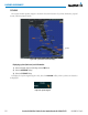
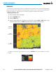
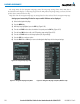
TodisplaytheIcingPotentiallegend(Figure6-42),selectthe
LEGEND
SoftkeywhenIcingisselectedfor
display.
Figure 6-42 Icing Potential Legend