
Pilot's Guide

190-00663-02 Rev. B
Garmin G1000 Pilot’s Guide for the Hawker Beechcraft C90A/GT/GTi
333
HAZARD AVOIDANCE
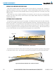
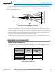
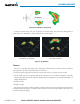
Figure 6-56 Angle of Incidence
Asmallerincidentanglegivestheradaralargerdetectablerangeofoperationandthetargetdisplayshows
ahigherintensity.Sincemoreradarenergyisreectedbacktotheantennawithalowincidentangle,the
resulting detectable range is increased for mountainous terrain.
SAFE OPERATING DISTANCE
The following information establishes a minimum safe distance from the antenna for personnel near
operatingweatherradar.TheminimumsafedistanceisbasedontheFCC’sexposurelimitat9.3to9.5GHzfor
generalpopulation/uncontrolledenvironments,whichis1mW/cm2.SeeAdvisoryCircular20-68Bformore
information on safe distance determination.
MAXIMUM PERMISSIBLE EXPOSURE LEVEL (MPEL)
ThezoneinwhichtheradiationlevelexceedstheUSGovernmentstandardof1mW/cm2isthesemicircular
areaofatleast11feetfromthe12-inchantenna.Allpersonnelmustremainoutsideofthiszone.Witha
scanningorrotatingbeam,theaveragedpowerdensityattheMPELboundaryissignicantlyreduced.