
Pilot's Guide

Garmin G1000 Pilot’s Guide for the Hawker Beechcraft C90A/GT/GTi
190-00663-02 Rev. B358
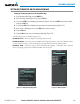
HAZARD AVOIDANCE
1) Press the MENU Key.
2)
Select ‘View Arc or ‘View 360º’ (choice dependent on current state) and press the ENT Key to change the view
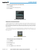
Showing/hiding aviation information on the TAWS-B Page:
1) Press the MENU Key.
2) Select ‘Show Aviation Data’ or ‘Hide Aviation Data’ (choice dependent on current state) and press the ENT Key.
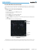
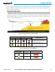
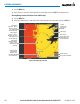
Figure 6-84 TAWS-B Page, 360º View
Yellow Terrain
(Caution - Terrain
Between 100’ and
1000’ Below the
Aircraft Altitude)
Red Terrain
(Warning - Terrain
Above or Within
100’ Below the
Aircraft Altitude)
Terrain Legend
Map Range
Black Terrain
(Terrain More than
1000’ Below the
Aircraft Altitude)
Annunciation Window
Red Lighted
Obstacle is Above
or Within 100’
Below Aircraft
Altitude
Yellow Lighted
Obstacles are
Between 100’
and 1000’ Below
Aircraft Altitude
Current
Aircraft GPS-
derived GSL
Altitude