
Pilot's Guide

190-00663-02 Rev. B
Garmin G1000 Pilot’s Guide for the Hawker Beechcraft C90A/GT/GTi
367
HAZARD AVOIDANCE
6.5 PROFILE VIEW TERRAIN
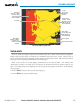
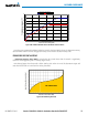
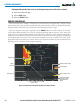
TheG1000offersaProleViewofterrainandobstaclesrelativetotheaircraft’scurrentightpathandaltitude
ontheNavigationMapPageoftheMFD.ProleViewdoesnotprovideTAWS-Bterrainorobstaclecautionor
warning annunciations or voice alerts systems, nor does it display potential impact points inside the Profile View.
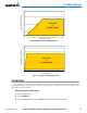
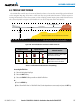
ThecolorsandsymbolsinFigure6-95andTable6-11areusedtorepresentterrainandobstacles.
1000 ft
Aircraft Altitude
100 ft Threshold
Terrain Above Aircraft Altitude
Red terrain is above
or within 100 ft below
the aircraft altitude
Yellow terrain is between 100 ft and 1000 ft below the aircraft altitude
Black terrain is more than 1000 ft below the aircraft altitude
Figure 6-95 Terrain Altitude/Color Correlation for Profile View Terrain
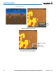
Unlighted Obstacle Lighted Obstacle
Obstacle Location
< 1000’ AGL > 1000’ AGL < 1000’ AGL > 1000’ AGL
Red obstacle is above or within 100 ft
below the aircraft altitude
Yellow obstacle is between 100 ft and
1000 ft below the aircraft altitude
Table 6-11 Profile View Terrain/Obstacle Colors and Symbology
Accessing Profile View:
1) Select the Navigation Map Page.
2) Select the MAP Softkey.
3) Select the PROFILE Softkey to enable or disable Profile View.
Or:
a) Press the MENU Key.
b) Select ‘Show Profile View’ or ‘Hide Profile View’ (choice dependent on current state) and press the ENT Key.