
Pilot's Guide


Garmin G1000 Pilot’s Guide for the Hawker Beechcraft C90A/GT/GTi
190-00663-02 Rev. B 465
ADDITIONAL FEATURES
8.2 SAFETAXI
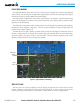
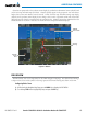
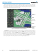
SafeTaxi is an enhanced feature that gives greater map detail when viewing airports at close range. The
maximum map ranges for enhanced detail are pilot congurable. When viewing at ranges close enough to
showtheairportdetail,themaprevealstaxiwayswithidentifyingletters/numbers,airportHotSpots,andairport
landmarksincludingramps,buildings,controltowers,andotherprominentfeatures.Resolutionisgreaterat
lowermapranges.Whenthe MFDdisplayis withintheSafeTaxiranges,the airplanesymbolon theairport
provides enhanced position awareness.
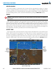
DesignatedHotSpotsarerecognizedatairportswithmanyintersectingtaxiwaysandrunways,and/orcomplex
rampareas.Airport HotSpotsareoutlinedto cautionpilotsof areason anairportsurface wherepositional
awarenessconfusionorrunwayincursionshappenmostoften.HotSpotsaredenedwithamagentacircleor
outline around the region of possible confusion.
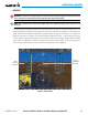
Any map page that displays the navigation view can also show the SafeTaxi airport layout within the maximum
configured range. The following is a list of pages where the SafeTaxi feature can be seen:
•NavigationMapPage
•InsetMap(PFD)
•WeatherDatalinkPage
•AirportInformationPage
•IntersectionInformationPage
•NDBInformationPage
•VORInformationPage
•UserWaypointInformationPage
•TripPlanningPage
•NearestPages
•ActiveandStoredFlightPlanPages