
Pilot's Guide

Garmin G1000 Pilot’s Guide for the Hawker Beechcraft C90A/GT/GTi
190-00663-02 Rev. B168
FLIGHT MANAGEMENT
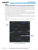
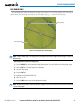
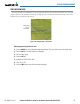
SELECTED ALTITUDE INTERCEPT ARC
The map can display the location along the current track where the aircraft will intercept the selected altitude.
The location will be shown as a light blue arc when the aircraft is actuallly climbing or descending.
Figure 5-30 Navigation Map - Range to Altitude Arc
Range to
Altitude Arc
Displaying/removing the selected altitude intercept arc:
1) Press the MENU Key with the Navigation Map Page displayed. The cursor flashes on the ‘Map Setup’ option.
2) Press the ENT Key. The Map Setup Menu is displayed.
3) Select the ‘Map’ group.
4) Press the ENT Key.
5) Highlight the ‘SEL ALT ARC’ field.
6) Select ‘On’ or ‘Off’.
7) Press the FMS Knob to return to the Navigation Map Page.