
Pilot's Guide
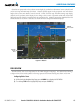

Garmin G1000 Pilot’s Guide for the Hawker Beechcraft C90A/GT/GTi
190-00663-02 Rev. B466
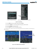
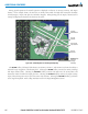
ADDITIONAL FEATURES
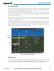
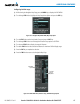
During ground operations the aircraft’s position is displayed in reference to taxiways, runways, and airport
features.Intheexampleshown,theaircraftisontaxiwayBravoinsidetheHighAlertIntersectionboundary
onKSFOairport.AirportHotSpotsareoutlinedinmagenta.Whenpanningovertheairport,featuressuchas
runway holding lines and taxiways are shown at the cursor.
Figure 8-14 SafeTaxi Depiction on the Navigation Map Page
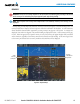
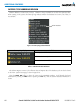
DCLTR
Softkey
Removes
Taxiway
Markings
Airport
Features
Aircraft
Position
Taxiway
Identification
Airport Hot
Spot Outline
The DCLTRSoftkey(declutter)labeladvancestoDCLTR-1,DCLTR-2,andDCLTR-3eachtimethesoftkeyis
selected for easy recognition of decluttering level. Selecting the DCLTRSoftkeyremovesthetaxiwaymarkings
and airport feature labels. Selecting the DCLTR-1 Softkey removes VOR station ID, the VOR symbol, and
intersection names if within the airport plan view. Selecting the DCLTR-2Softkeyremovestheairportrunway
layout, unless the airport in view is part of an active route structure. Selecting the DCLTR-3Softkeycyclesback
totheoriginalmapdetail.RefertoMapDeclutterLevelsintheFlightManagementSection.