
user manual


190-00498-07 Rev. A
Garmin G1000 Pilot’s Guide for Cessna Nav III
SYSTEM
OVERVIEW
FLIGHT
INSTRUMENTS
EIS
AUDIO PANEL
& CNS
FLIGHT
MANAGEMENT
HAZARD
AVOIDANCE
AFCS
ADDITIONAL
FEATURES
APPENDICES INDEX
365
HAZARD AVOIDANCE
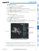
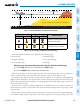
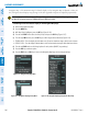
1000 ft
Aircraft Altitude
100 ft Threshold
Terrain Above Aircraft Altitude
Red terrain is above
or within 100 ft below
the aircraft altitude
Yellow terrain is between 100 ft and 1000 ft below the aircraft altitude
Black terrain is more than 1000 ft below the aircraft altitude
Figure 6-115 Terrain Altitude/Color Correlation for Terrain Proximity
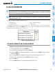
Unlighted Obstacle Lighted Obstacle
Obstacle Location
< 1000’ AGL > 1000’ AGL < 1000’ AGL > 1000’ AGL
Red obstacle is above or within 100 ft
below the aircraft altitude
Yellow obstacle is between 100 ft and
1000 ft below the aircraft altitude
Table 6-13 Terrain Proximity Terrain/Obstacle Colors and Symbology
Terrainandobstacleinformationcanbedisplayedonthefollowingpages:
•PFDInsetMap
•NavigationMapPage
•TerrainProximityPage
•TripPlanningPage
•ActiveFlightPlanPage
•VideoPage
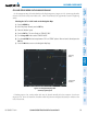
Displaying terrain and obstacle information (maps other than the Terrain Proximity Page):
1) Press the MAP Softkey (for the PFD Inset Map, press the INSET Softkey).
2) Press the TERRAIN Softkey to display terrain and obstacle data.
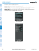
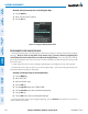
WhenTerrainProximityisselectedonmapsotherthantheTerrainProximityPage,anicontoindicatethe
featureisenabledfordisplayandalegendforTerrainProximitycolorsareshown(Figure6-119).
TheNavigationMapPageSetupMenuprovidesameansinadditiontothesoftkeyforenabling/disabling
displayofterrainandobstacles.Thesetupmenualsocontrolsthemaprangesettingsabovewhichterrainand
obstacledataaredeclutteredfromthedisplay.Ifamaprangelargerthanthemaprangesettingisselected,the
data is removed from the map.
Terraindatacanbeselectedfordisplayindependentlyofobstacledata;however,obstaclesrecognizedby
TerrainProximityasyelloworredareshownwhenterrainisselectedfordisplayandthemaprangeiswithin
the setting limit.
MapsbesidestheTerrainProximityPageusesettingsbasedonthoseselectedfortheNavigationMapPage.
The maximum display ranges for obstacles on each map are dependent on the range setting made for the