
Operation Manual

offered by Busse-Yachtshop.com
20 21
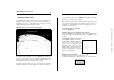
NAVIONICS ELECTRONIC CHARTS
The GEONAV includes a built-in world map. Additional car-
tography details relative to a specific area of navigation are
available from the CompactFlash™ cartridges storing
NAVIONICS Seamless™ electronic charts.
NAVIONICS electronic charts contain the following data:
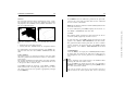
To display chart boundaries, press the PAGE key to display the
menu, select SETUP, then the CHART BOUNDARY option
and, by the joystick, select ON/OFF to enable/disable the
boundaries of the charts stored in the cartridge.
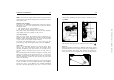
A small square will locate the area covered by the cartridge
installed; position the cursor within the square and then de-
crease the chart range by the ZOOM+ key to display the details
of the area covered by the cartridge.
The maximum detail level is obtained within port plans and
can reach 1/8 nautical mile (the smallest point on screen is
equivalent to approximately 1 meter), depending on the car-
tridge type and coverage.
Increasing/decreasing the chart range
Press the -ZOOM+ key.
Displaying depth contours, geographical names and ports
Press the PAGE key to display the menu, select SETUP and
enable the options desired (DEPTH CONT. or NAMES) by the
joystick.
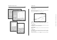
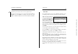
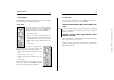
Converting depth values into the units set
Press PAGE to display the menu,
select SETUP, DEPTH UNITS and
then set the unit desired in
meters, feet or fathoms. The
GEONAV will convert all the
depth values in the unit selected,
making them appear like those re-
ported in the official nautical
charts (see the figure).
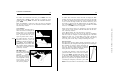
Displaying navaid characteristics
Position the cursor on the navaid symbol
A window will show the characteristics of the navaid selected.
NAVIONICS Electronic Charts