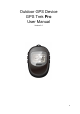
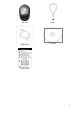
Outdoor GPS Device GPS Trek Pro User Manual Version 3.
Table of Contents 1. Introduction and Features ........................................................................................... 3 1.1 Introduction ....................................................................................................................................... 3 1.2 Features............................................................................................................................................ 3 2. Specifications ..........................................
11.2 How to use the GS-Sport Travel Manager Software..................................................................... 24 11.3 Travel Manager ............................................................................................................................. 25 11.4 Main menu .................................................................................................................................... 28 11.5 File Menu ........................................................................
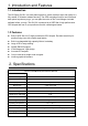
1. Introduction and Features 1.1 Introduction The GS-Sport GH-561 is a route-planning device, which combines style and rigidity in a fully sealed, IPX4 water resistant housing. The GPS navigation function can locate and track points anywhere you go, you can plan the route on the Travel Manger included software before your trip. The GH-561 is powered by a SiRF Star III high performance GPS chipset that can fix your position even with a weak signal status. 1.
Power Consumption Battery life GPS ( 3D fixed) , Backlight on 75mA GPS ( 3D fixed) , Backlight off 50mA GPS ( 3D fixed) , Backlight on 19 hrs GPS ( 3D fixed) , Backlight off 30 hrs Connect to PC Interface USB interface Charger Mini USB 350mA, 3 hours completed Electronic Compass YAMAHA YAS52P 3Axis GPS Parameters General GPS Chipse SiRF Star III LPx Frequency L1, 1575.42 MHz C/A code 1.
GH-561 USB Cable Strap CD-ROM Quick Guide 5
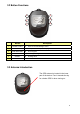
3.2 Button Functions 1 4 2 5 3 6 Button Description 1. POWER / LIGHT z Power on/off and Backlight control 2. MARK W.P. / ESC z Mark points and escape to last page 3. FIND WAYPOINT z Go to waypoint 4. TRACK BACK z Following traveling route 5. SCROLL z Scrolling select 6. OK z Enter and confirm 3.3 Antenna Introduction The GPS antenna is located in the lower part of the device. Face it towards the sky for a better GPS fix when turning on.
3.4 Battery Introduction The GH-561 uses a built-in Li-Polymer rechargeable battery. A battery icon shown on the left bottom corner of screen indicates the remaining battery power. z To charge the battery: 1. Connect one end of the provided USB charging cable with the GH-561 unit and the other end with the AC adapter or USB port on your PC. 2. The GH-561 unit may need about 5-6 hours to fully charge the battery. Note: Please fully charge before first use. 4. Getting Started 4.
4.2. Icon Explanation The battery icon indicates the remaining battery power. Blinking means the device has little battery power left. E-Compass status indicator - Blinking: The E-Compass is experiencing magnetic interference or is unstable, the device will need to be re-calibrated. GPS status indicator z z z z z No bars: No signal Blinking: 2D fix Solid: 3D fix Solid with 1 bar: 3D fix with poor signal Solid with 2 bars: 3D fix with good signal z Solid with 3 bars: 3D fix with strong signal 5.
(b) After modified, click ‘’FOLLOW?’’ to start route navigation. (b) (c) Then select ’’ backward’’ or ‘’ forward’’ to start the trip. (c) 3. The E-Compass will show the direction on display along with the rest of the distance and estimated time of arrival based upon your current speed. 4. Press ‘’OK’’ button will show map page. 5. Press button will guide you to the next point, press ‘’ OK’’ button will guide you previous waypoint. Press or button to zoom in or zoom out map page.
5.2 Quit Current Route 1. Press the button to exit the route when you want to quit on your current route. 2. Press the ‘’ YES’’ button, the E-compass will stop the selected route. 6. Waypoint 6.1 Waypoint Saving z If you want to record where you car is parked or an interesting place, you can perform this by following these steps. 1. Press the waypoint”. 2. There are a total of 10 waypoints that can be button to enter “create a saved on this device.
7. Find a waypoint 7.1 GO TO z If you want find your parked car or interesting place, you can perform this by following these steps. 1. Press the to choose the desired waypoint. 2. Press the “OK” BUTTON, the E-compass will guide you to your destination. 6. Press ‘’OK’’ button will show map page. 7.2 Deleting a Waypoint 1. Press the button to choose the waypoint you want to delete. 2. Press ‘’DELETE’’ to delete to desired waypoint, you will then be returned to the previous page.
7.3 Stop GO TO function 1. If you would like to stop the go to function, press the button. A window will pop up asking you if you would like to ‘’EXIT GOTO’’ 2. Press the ‘’ YES’’ button. 3. The compass will stop the trip. 8. Calibration z If you would like to perform a compass calibration or the compass symbol is blinking, you may perform a compass calibration by following these steps: 1. and buttons Pressing the simultaneously will result in entering the calibration display. 2.
confirmation window will pop-up asking to confirm calibration. Please press to return to the previous menu screen. 9. Setting z This functionality is used to personalize your settings. Press the and buttons together. This will enter the settings display, the settings display can only be opened through the Location screen or E-compass screen. 9.1 Compass Setting z [Calibration] 1. Follow the on screen steps to calibrate the device. z [Declination] 1.
9.2 Setup Time Use the or buttons to scroll to the item and press OK to modify it. z [TIME ZONE] You must select your country to set up the time zone z [DAYLIGHT SAVINGS TIME] You have to select your local time zone and enable Daylight Savings Time if necessary, so system will display the correct time for you. z [TIME FORMAT] You can also set the time to display the 12 Hour or 24 hour format.
9.3 Display Setting z [BACKLIGHT] Set the backlight to stay on or automatically turn off after a period of time once you press Power button to activate the backlight. z [CONTRAST] 1. Use the and buttons to adjust the contrast of the screen. When the adjustments to the contrast 2. have been made press the “OK” button to accept the adjustments. Press button to exit or go back to main menu 9.4 GPS Setting Turn on/off the ‘’WAAS/ENGOS’’ feature. Press button to exit or go back to main menu. 9.
2. It is recommending to set 50m for walking, and 100m for cycling. 3. If the speed range is higher than the switch distance should be above 100m to get accurate navigation. Press button to exit or go back to main menu 9.7 Set Units The measurement unit can be set as "statute" or "metric" or ‘’nautical’’. . Press button to exit or go back to main menu 9.8 GPS Info In this screen you can see the positioning status of how many satellite signals are obtained and their signal strength.
Press button to exit or go back to main menu 9.10 About This screen displays the firmware version information. Press button to exit or go back to main menu 10. How to install PC software application 10.1 Installing the USB driver The USB driver is required to recognize your GH-561 via USB when it is connected to your PC. 1. Insert the CD into the CD-ROM drive, and the Auto-run will begin. 2. Click on the "GS-Sport Travel Manager" to install driver to your PC. 3.
¾ Step 2: Connect the GH-561 device to your PC and follow the instructions below circled in red. “Please, connect your device, the “Found New Hardware Wizard” window will pop up; cancel it to ignore automatic hardware installation.
¾ Step 3: The USB driver installation has been accomplished. To check Computer Management>Device Manager you may see the STM Virtual COM port has been detected. 10.2 Installing the Travel Manager z Install Framework v2.
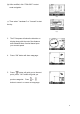
1. To check the Microsoft Framework version in your system go to: Control Panel > Add/Remove Programs Note: Originally, the Framework version in Windows XP SP2, SP3 and Vista or above should be version 2.0. z Installing the GS-Sport Travel Manager Use auto-run to install GS-Sport Travel Manager or select the installation file from the CD-ROM. ¾ Step 1: Click Setup.exe to install the travel manager.
¾ Step 5: Installation process. z ¾ The software will execute and connect the database automatically. Step 6: Press ‘‘close’’ to enter the travel manager installation application.
¾ Step 7: Create a user account and save it. ¾ Step 8: After saving the program will login automatically. z The process bar will detect connection via the USB cable. ¾ Step 9: Plan your route.
10.3 Running the GS-Sport Travel Manager Application You can run the GS-Sport Travel Manager by double clicking on the "GS-Sport Travel Manager" short-cut icon from desktop. Or go to Start > All Programs > GlobalSat GS-Sport > Travel Manager. 11. PC Software Application 11.1 System Requirement For better performance, the following system requirements are recommended for GS-Sport Travel Manager: z CPU: Pentium III Processor or higher. z At least 512 MB of RAM z Windows XP or Vista z Internet Explorer 6.
11.2 How to use the GS-Sport Travel Manager Software 11.2-1 Create a user name z You should have been prompted to create a user name when you installed the software z Login Note: 1. You can create other user names to login and import backup database as well. 2. Please be sure that you are connected to the Internet before the software is opened. 11.2-2 Importing Data You should export the database before you go on to import the data. Click ‘’import data’’ to transmit the whole database you’ve exported.
z Click the file you’ve exported (*.travelbook),The Import process will run automatically. 11.3 Travel Manager 11.3 – 1 Section Description 1. 2. 3. 4. 5. 6. 7. 8.
26
11.3 - 2 Software Control Function description Icon Icon Description Open file Show on Google earth Show on Google map Search Log out Exit 11.3 - 3 Menu Structure Main Files Search Data Capture Google Map Capture current Google Map window as JPG or BMP format Show on Google Map Show Training data on Google Map. Show on Google Earth Show Training data on Google Earth. You can see the training data which be selected on google earth. Export Database Export travel information to Travelbook format.
Help Language Six Language selection (English, Traditional Chinese, Spanish, German, Italian, French and Japanese) Check update Check the latest version from About GS-Sport GS-Sport introduction About US The team information 11.4 Main menu 11.4 – 1 Capture Google Map z Capture current Google map window and save it as JPG format 11.4 – 2 Show on Google Map z Show the planned route on Google map directly 11.
11.4 – 4 Export Database Export the whole database of software to ‘’*.travelbook’’ file for backup. z To name the database and save it.
z Database export completed successfully 11.5 File Menu 11.5 - 1 Open file st ¾ 1 Step : Select the saved file and you want to put data into software. The window will show’’ Do you want to save this file information into database’’, click ‘’OK’’. ¾ 2nd Step : the progressing message will be displayed on screen.
¾ 3rd Step: The message: “The file has been saved into the database successfully” will pop-up.
11.5 - 2 Save file st ¾ 1 Step: Save the file as gpx, or kml format. ¾ 2nd Step: Save the file successfully.
11.6 Search Menu z Search the travel data by date 11.7.1 Planning Menu 11.7.1 - 1 Planning Route In GS-Sport Travel Manager, click [Planning] > [Planning Route ] Start to plan route on map, click every points step by step. Press ’’ End Route’’ stop planning route.
¾ ¾ Delete Route : Cancel the whole route you just planned Undo Route : Cancel last of one track you just planned. 11.7.1 - 2 Upload Route to GH-561 device ¾ 1st step : Connect GH-561 to your PC with the USB cable, then the device will show ‘’ Connect To PC’’, please press’’ YES’’ ¾ 2nd Step : The device will show ‘’Synchronize To PC ‘’ automatically. ¾ 3rd Step: On Travel Manager, click [Planning] > [Upload Route] to select the data (right bottom column) you want to transmit.
¾ 4th Step: Once the data succeeded in transmitting, device will show ’’Route data download O.K’’ ¾ 5th Step: The travel manager will show’’ Uploading Route completed successfully’’ 11.7.1 - 3 Delete All From Device ¾ ¾ 1st step: Connect GH-561 to your PC with the USB cable. On Travel Manager, press [Planning] > [Delete all from device] 2nd Step: The window will show’’ are you sure you want to delete all route records from device’’ click yes will erase all data.
¾ 3rd Step: Once all data be deleted, the window will show as below ¾ 4th Step: The device is clean. 11.7.1 - 4 Edit Route ¾ 1st step: Select the data on right column and click the right button on the mouse. ¾ 2nd step: To edit the name and save it.
¾ 3rd step : Edition finished 11.7.2 Waypoint 11.7.2 – 1 Add Waypoint In GS-Sport Travel Manager, click [Planning] > [Add Waypoint] Click the Google map to add waypoint. Press [Add waypoint] icon on the bottom then create the waypoint. Press [Stop waypoint] icon to finish waypoint.
11.7.2 – 2 Upload Waypoint to GH-561 device ¾ 1st step : Connect GH-561 to your PC with the USB cable, then the device will show ‘’ Connect To PC’’, please press’’ YES’’ ¾ 2nd Step: The device will show ‘’Synchronize To PC ‘’ automatically. ¾ 3rd Step : On Travel Manager , select the ‘’ waypoint’’ bar to choose the waypoints you want to transmit. Then click the [Planning] > [Upload Waypoint] to select the waypoints you want to transmit.
1. 2 ¾ 4th Step : Once the data succeeded in transmitting, device will show ’’Route data download O.K’’ ¾ 5th Step: The travel manager will show’’ Uploading Route completed successfully’’ 11.7.2 – 3 Edit Waypoint ¾ 1st step :Select the waypoint click the right button on the mouse.
1. 2. ¾ 2nd step: To edit the name and save it.
11.8 Configuration Menu 11.8 – 1 Com Port Setting z Scan COM Port” button. COM port will be automatically scanned. 11.
11.8 – 3 Unit Exchange z Three Unit selection(Metric, Statute and Nautical) 11.
11.9 Help Menu 11.9 – 1 Check Update z Check the latest version 11.9 – 2 About GS-Sport Will pop up a window to show the version 11.9 – 3 About US Will connect to Globalsat website directly. The line is http://www.globalsat.com.tw/eng/index.htm 12. Maintenance 12.1 Take care of you GH-561 z z Do not store your GH-561 in an extremely high or low temperature environment. Use a dampened cloth to clean your GH-561 and wipe dry. If necessary, apply mild detergent solution to the cloth.
13. Glossary Relates to data being transmitted from GH-561. Activity is a history Activity or log of events. Activity data includes time or distance updates. Waypoints are sets of coordinates that identify a point in physical space. For the purposes of terrestrial navigation, these coordinates Waypoint usually include longitude and latitude, and sometimes altitude (particularly for air navigation). Trackpoint The current moving trace.
FCC Notices This device complies with part 15 of the FCC rules. Operation is subject to the following two conditions: (1) This device may not cause harmful interference, and (2) This device must accept any interference received, including interference that may cause undesired operation. FCC RF Exposure requirements: This device and its antenna(s) must not be co-located or operation in conjunction with any other antenna or transmitter.
) and KML (Google Earth Format). 4. Why can I export data to Google Earth, but can’t export data to Google Earth Pro? Solution: Since the installed directory are different between Google Earth and Google Earth Pro, sometimes you can’t wake up it directly by click on GS-Sport Travel Manager Software; you have to follow the bellowing procedure to wake up it: (1).
Solution: (1). Please make sure is there any magnetic interference close to device (2). Please follow the instruction of user manual to calibrate compass (3). The poor reception from GPS signal will effect performance as well, Please toward to sky to keep good signal. 8. Why can’t my GH-561 communicate with PC? Solution: (1). Please make sure that you have installed STM32 USB driver. (2). Please make sure the com port has been set correctly FCC Notices This device complies with part 15 of the FCC rules.