
Item Brochure

Haglöf Sweden AB Ph: +46 620 255 80 info@haglofsweden.com www.haglofsweden.com. ©Haglöf Sweden 2015. All rights reserved
The DP GPS
Haglöf Sweden’s DP II caliper works with different software-run
add-ons and accessories, designed to improve accuracy, efciency
and versatility. With add-on instruments mounted on the DP
caliper com-port, battery and display are supplied from the caliper.
The DP GPS module enables you to position and navigate
with your computer caliper as you are performing your regu-
lar eldwork. The DP GPS is attached to the host computer
and becomes an integrated part of your caliper. The module
is controlled through the DP caliper, runs with its battery,
display and processor, and leaves you with less worries about
charging time, connectivity and compatibility.
The DP GPS has a 33-channel high-sensitivity receiver that
supports several satellite systems such as GPS, Glonass, Galileo
and GZSS. The ability to use several satellites from different
systems at the same time improves positioning in difcult ter-
rain. The built-in real time correction allows for accuracy down
to 2.5m/8.19ft in open terrain. Algorithms can predict satellite
positions for up to 3 days, using data from last used satellite con-
stellation saved for up to one month in the GPS with a built-in
rechargeable battery.
Depending on software application in your DP II computer
caliper there are numerous ways to integrate the DP GPS mod-
ule in your eld cruising routine. Collect measuring data and
conenct with positions on sample plots, stand areas, areas with
special biotops, individual trees, and roadside timber loads. Make
a tracking log of borderlines in a plot and have the DP caliper
calculate the total area. Preload positions for marked trees and
hazard trees and navigate straight to them. Revisit an area, and
instantly nd your way. With all eld data registered, collected
and available in one secure place in your DP computer caliper,
no additional instruments or eld computers are needed. WIth
the DP caliper and DP GPS module you can save time and ensure
compliance. The GPS module is very small and will not affect
balance and weight of the DP II caliper when attached. Also avail-
able as a combination module including DP GPS and DME for
efcient ultrasound distance measuring in sample plots.
TECHNICAL SPECIFICATION DP GPS
Dimensions: 57x30x30mm/2.28”x1.2”x1.2”
Weight: 25g/1oz
Satellite systems: Host-based multi-global navigation: GPS(Usa)/GLONASS
(Russia)/Galileo(EU)/QZSS(Japan). SBAS Satellite-based aug-
mentation systems: WAAS(USA), EGNOS(EU), GAGAN(India),
MSAS(Japan)
Orbit prediction: Built in self-generated (Faster TTFF up to 3days)
Serial interfaces: UART 115200bps, 8bits, no parity, 1 stop bit. 3D-FIX Led
Geodetic date: WGS84
Protocol: NMEA. Messages: GGA: Time, position and x type data.
GLL: Lat, long, UTC time of position x and status. GSA:
GNSS receiver operating mode, satellite used and DOP
values. GSV: Number of satellites in view ID numbers, eleva-
tion, azimuth and SNR values. RMC: Time, date, position,
course and speed data. VTG: Course and speed informa-
tion relative to the ground
Performance data: Receiver type 33 tracking/99 acquisition- channel GNSS
receiver. Update rate 1Hz (max 10Hz).
Sensitivity: Tracking: -165 dBm-. Reacquisition: -160 dBm
Cold starts: -147 dBm. Time-To-First-Fix: (All SV @ –130 dBm)
Cold starts: 28s up to 15min (open sky). Warm starts: 26s
(open sky). Hot starts: <1s (open sky, <2h since last start)
Accuracy:
Automatic Position. 2.5m CEP (circular error probable)
(50% 24 hr static, -130dBm)
Speed: 0.1m/s. (50%@30m/s)
Temperature: -40
°
~+85
° C
Electrical data Power supply 2.8~4.3V. Power consumption @ 3.3V (typical)
Acquisition: 35mA. Tracking: 30mA. Backup:14uA
Other: Built in jamming removing. Built in rechargeable backup
memory. DP II requires Bios V2.16 and forward. Digitech
Professional I requires Bios V1.73 and forward. For details
on the DME function in DP GPS DME, please see product
info for DP DME.
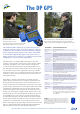
Image above shows
the DP GPS DME module on
the DP II terminal com-port.
Use with the DP GPS, the DP Postex and the DP
DME modules. All functions are software run.
DP GPS 13-600-1081 module only, blue. 13-600-1082 DP
GPS DME combination, module only, blue/black. (Image to the
right is a DP GPS DME.) The DME function is used with T3 trans-
ponder and monopod sta, please see product information on
DP DME. Functionality of modules is software run through the
DP II computer application.