
Use and Care Manual

123
AutoChart Live
7
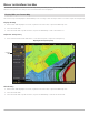
. Press and hold the EXIT key to close the menu system.
8. If there are additional control heads on your boat with a 2D transducer, confirm that they are not pinging while you are
mapping. There should be only one 2D transducer pinging on your boat during the recording process.
3
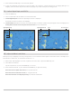
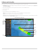
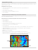
| Confirm Digital Depth and GPS Fix
1. Press the HOME key.
2. Select a Chart View from the Views tool or the Favorites bar.
3. Confirm Digital Depth: Confirm the depth digital readout is displayed.
It may take a moment for depth to be displayed.
4. Confirm GPS Fix: Review the status bar and confirm the GPS icon is white. Confirm the speed digital readout is displayed. See
Getting Started: Check Sensor Reception and Connections for more information.
4
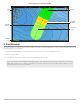
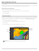
| Adjust the Water Level Offset
When you start your mapping for the day, it is important to note if the water level is higher or lower than usual. For example, if you
know the lake is down 3 feet, set the Water Level Offset to -3.
1. With a Chart View displayed on-screen, tap Chart in the status bar, or press the MENU key once.
2. Select Water Level Offset.
Tap the on/off button, or press the ENTER key, to turn it on.
3. Press and hold the slider, or press and hold the ENTER key, to adjust the setting.
If the water level is higher than normal, set a positive amount.
If the water level is lower than normal, set a negative amount.
If the water level has not changed (normal), turn off Water Level Offset.
digital depth detected GPS sensor checkdigital depth missing speed