
User Guide

25
7
CALL PROCEDURE
7
✔
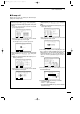
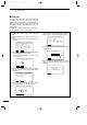
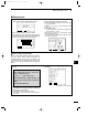
For your information— Area input
When using the ‘Geographical’ for distress relay call
with “Area” selection, your original position is always
the upper left hand corner in the world map as in the
following illustration.
10˚N
100˚W
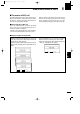
• Area setting example 1
Latitude
20
N-H:10
Longitude
100
W-V:20
20˚N
80˚W
20˚N/100˚W
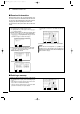
• Area setting example 2
Latitude
20
S-H:10
Longitude
100
E-V:20
20˚S
120˚E
20˚S/100˚E
10˚N
80˚W
30˚S
120˚E
30˚S
100˚E
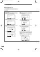
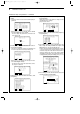
o After sending the call, the transceiver selects the
set traffic frequency automatically.
!0 Announce the following message.
!1 After the announcement, push [FREQ/CH] to return
to DSC watch mode.
• ‘Urgency’ is selected in step
ee
• “PAN PAN”
• ‘Safety’ is selected in step
ee
• “SECURITE” (repeat 3 times)
• This is …… (your ship name)
•The 9-digit identity and the call sign (or
other identification of the ship).
• The text of the urgency or safety message.
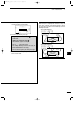
RX
J3E
GPS
<
Traffic
>
Lat
34
34'N
Lon135
34'E
12:34
Exit
IC-M801E_0.qxd 05.12.2 16:32 Page 25