IKE 4 user manual IKE 4 user manual Copyright © 2016 IKEGPS LTD. 1 IKE4-000-00-00-1.
Visit http://ikegps.
contents introduction X what’s in the box X IKE 4 system overview X system setup X IKE 4 tripod X IKE Field – how it works IKE Office X IKE Field X IKE 4 user manual 3
Introduction Thank you for purchasing the IKE 4 Your IKE 4 is a location-based measuring solution that will greatly increase your productivity when undertaking utility asset management surveys and related measurements. The IKE 4 integrates a digital camera, compass, laser range finder, mobile computer, and precision GPS.
What’s in the box 1 2 3 4 5 6 7 8 1 7 4 IKE device USB car charger power cable micro USB cable AC charger with plug adapter screwdriver shoulder strap for hard case hard case (not shown) A SIM card and SD card are not included. IMPORTANT: The IKE 4 device is designed to be used with the IKE Tripod. It should not be used while being held by hand or placed close to the user’s body.
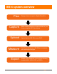
IKE 4 system overview Plan Capture Upload 6 Design a form or import a Spida Client file Make measurements and capture data in your forms using the IKE Field device Upload data to IKE Office over Wi-Fi Measure Use Photo Measure in IKE Office to measure pole attachment heights Export Export your collections to one of the following formats: KML, JSON, PDF or SPIDA IKE 4 user manual
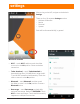
system setup IKE 4 software IKE Office IKE Office makes data transfer from your IKE Field device simple. Customize and deploy forms directly to your IKE Field device and export various file types from captured data. Make accurate photo measurements and save marked-up photos. IKE Field Your device has been shipped with the latest factory software — your installed version shows on the IKE Field device main screen. However, the team at IKE regularly makes product improvements.
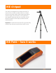
IKE 4 tripod Your device is designed to be used with the IKE 4 tripod, which provides a stable platform to obtain the most accurate results when measuring objects such as target poles and wires. The tripod has a low magnetic signature that will not affect the IKE device’s compass, which helps provide accurate measurements. Important: Tripods other than the IKE tripod will likely produce less accurate results than the IKE tripod.
IKE Field IKE Field Signing In Settings Creating a job Downloading forms Starting a collection Viewing the map Uploading data Making measurements signing In 1. Sign in to the application with the same email and password as you used for IKE Office. This user information will be saved, so the next time the application is opened it will already be logged in to the most recent account.
settings After turning on the IKE, navigate to the device’s Settings. There are four (4) separate Settings sections: • Wireless & networks • Device • Personal • System Each will be discussed briefly, in general. Wireless & networks • Wi-Fi — touch Wi-Fi, and then touch the slider to move it to the On position. Chose a wireless connection. • Turbo download — touch Turbo download to download large files (>20 MB) faster, using the WiFi and 4G/3G networks simultaneously.
• • • • • More — Touch More to access Airplane mode Tethering & portable hotspot VPN Cellular networks IKE 4 user manual 11
settings 1. After turning on the IKE, navigate to the device’s Settings. 2. Move to the Wireless & networks section. 3. Select the router you want. 4. Enter the router’s password and select CONNECT. For extended Internet coverage, use a standard AT&T SIM card, or a micro or nano card with an adapter, in the IKE SIM card slot under the battery. Refer to IKE 4 Training Module 4 for further details.
5. Navigate: Settings > Device > Display There you can change • Brightness level • Adaptive brightness • Sleep Change the Brightness level for easy viewing. Adjust the Adaptive brightness, depending on the light in your environment. Change the Sleep mode setting to save battery life during periods of inactivity.
6. Navigate: Settings > Personal > Location Touch Location to manage: • Location settings • Satellite-based augmentation systems (SBAS) For the IKE device’s GPS to function correctly, SBAS must be turned on • • Location — touch Location, and then touch the slider to move it to the On position. SBAS — touch the SBAS slider to move it to the On position. IKE Settings 1. Sign in to the IKE Field app, using the same sign in information as the IKE Office account. The app opens to the My Jobs screen. 2.
creating a job 1. To create a job, navigate to the My Jobs screen. 2. Touch the orange plus icon . 3. Enter the name of the Job. 4. Touch ATTACH FORM. When connected to the Internet, the page will automatically check for available updated and new forms.
5. Tap DOWNLOAD to download the latest forms. When forms are downloaded, you have access to them, even without Internet connectivity. 6. Select the form you want to use.
7. When the job has a name and a form attached to it, tap the CREATE button in the top right. To ensure you have the resources for data collection, we recommend creating a job and applying the form before going on site. If your IKE device has a SIM card or Wi-Fi connectivity in the field, you will be able to receive form updates. 8. The My Jobs screen shows all of the jobs on the device. Select the Job you wish to work on to proceed.
9. Now you are ready to start collecting form data. Tap the button to create your first collection. 10. You can enter data directly into the on-screen form and use tools to make measurements. Anything with a plus button can be repeated multiple times.
11. Tap the next to equipment sub-form to start collecting data about that attachment. 12. When you have collected all of the information about the equipment, click the done button at the top right.
13. You can see that one piece of equipment has been captured. Tap the Save icon to keep this information. Tap the Back icon to go back to the Job screen. 14. The Job screen shows all of the collections you have made for this job in both a list and on a map. Tapping the down arrow next to a collection shows a summary.
15. The summary gives you an overview of a collection by showing which sub-forms have been collected. 16. Tapping the Map tab shows your collections for this job on a map. 17. Tapping the will take you to the form screen to add another collection. 18. Tapping on the location balloon will take you to that collection.
uploading data After you’ve collected the data, you will want to upload the data to the IKE Office. 1. Re-establish a Wi-Fi connection or utilize a data package through an AT&T SIM card, if necessary. 2. Return to the jobs list on the My Jobs screen. 3. Touch the gray, outlined circle to the left of the job name. 4. Ensure the number to the left of the job becomes highlighted in gray and the correct number of selected files is indicated at the top of the screen. 5. Touch the upload arrow to upload your job.
making measurements Local GPS Position 1. To capture a location, select the field and choose from local position (GPS icon)(GPS only) or target position (Camera Icon) (GPS + laser offset). 2. For the Local GPS position tool, the current accuracy shows the expected accuracy of the position. Pressing START begins averaging GPS data over 30 seconds to get the best accuracy. Try not to move or cover the device during this process.
3. Counting down 4. Location captured. The green pin on the map shows the location captured. The blue dot shows your current location.
Target GPS Position 1. Aim at the target with the crosshair to ensure the laser is hitting the object you want to locate. 2. Ensure the crosshair color is green which indicates that all of the instruments (GPS, Compass and Laser) are providing information 3. Tap the blue capture button at the bottom of the screen to take a picture and capture the location.
Point to Point 1. Aim at the first target and capture when the crosshair turns green. 2. Aim at the second target and capture when the crosshair turns green.
3. The distance and bearing from Point A to Point B are calculated. 4. Click RETAKE if you’re not satisfied with your results.
Point to Point 1. Aim at the wire, wait for the crosshair to turn green and tap the capture button. 2. Use the orange guide arrows to locate the position directly below the wire.
3. When the arrows disappear and both the crosshair and the height measurement area turn green, tap the capture button. 4. The results screen shows the height of the wire and a photo with the crosshair.
Photo Measure 1. Aim at the pole with the crosshair. 2. Ensure the guideline that runs down the whole screen matches the angle of the pole. 3. When the crosshair is green tap the blue capture button at the bottom of the screen.
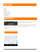
IKE Office IKE Office is a cloud-based file management system with which you can • create customizable forms • upload and download field data • measure heights of utility poles and their attachments logging in When signing into IKE Office for the first time use the admin login and password provided by ikeGPS. Enter these details, then click LOGIN.
summary screen The Summary screen shows the most recently uploaded collections and jobs. From here you can navigate to an individual job or collection. To access the summary, click Summary. A B C D E Now you see the following highlights of the uploaded jobs: • Number of features (A) • Pole ID (B) • Date and time of collection (C) • Thumbnail sets of collection captures (D) • More information (E) Clicking on a right arrow for more information shows you that pole’s complete information.
jobs screen The Jobs screen shows all the data uploaded from the IKE 4 device to the specific account. Jobs are displayed chronologically, based on the date they were collected. To access the jobs, click Jobs. By selecting a Job name, the job’s summary appears.
Now you see the following highlights of the uploaded jobs: • Number of features (A) • Pole ID (B) • Date and time of collection (C) • Thumbnail sets of collection captures (D) • More information (E) Clicking on a right arrow for more information shows you that pole’s complete information. Now you see all the data collected for this feature, such as • Pole ID • Location data • True Size capture • Sub-forms This data is shaped by form creation and field data collection.
forms screen The Forms screen shows all the available forms. From this screen you can add customizable forms to your account. To access the forms, click Forms. By selecting a form’s edit button, the Form menu appears, and you can Test a new form against a pole, to ensure you have all the necessary information for pole-loading analysis.
IKE Office quick guide logging in When signing into IKE Office for the first time use the admin login and password provided by ikeGPS. Enter these details, then click LOGIN. managing accounts 1. To add a new user, click on Accounts then on 36 .
2. Enter the user details, then click create. 3. When the confirmation message appears, copy the login details (username and password) and pass them on to the user. Click OK to close the window.
To delete a user or reset a password, click the More icon ( select the option required. ) to the right of the account and summary screen The summary screen shows the most recently uploaded collections and jobs. From here you can navigate to an individual job or collection. To access the summary, click Summary.
customising the date format and measurement units You can change the date format and measurement units. To do this, click Settings then click to select the preferred date format and/or measurement units. creating a form Note: It is important to set up the Internet connection to access your forms, especially the first time using the network. 1. To create a form, click on Forms then on .
2. Select the type of form you want to create. If you have a client.json file from ikeGPS, you can select Import SPIDACalc Client file to create a form specifically to be used with SPIDACalc. To create a form from scratch, select New Blank Form. 3. When the form is created, click SAVE to make the form available for download onto the IKE device.
The created forms are displayed as shown below. jobs and collections To display all the jobs collected for your organisation, click Jobs.
Selecting a job shows all of the collections for that job. Selecting an individual collection (>) will show all of the data collected on the form.
Mousing over an image shows a menu that allows you to view or go to Photo Measure Selecting a view shows a summary of the capture, including the photo, location and measurement details. Click outside the image to close the image.
measuring from a photo 1. Set the base of the pole by clicking on the photo near the bottom of the pole. 2. Select the first orange link on the right.
3. Click on the image to calculate the height for that field. Continue doing this for the other height fields in the form. • • • • • For accurate placement, use the zoom window on the right for a closer view. To edit the name of the marker on photo, double click on it. To save your measurements, click [save icon]. To go back to the collection screen, click [X icon] To delete all measurements on the photo, click [trashcan icon].
exporting An individual collection can be exported to KML, JSON, Print (PDF) or to SPIDACalc format. Multiple collections can also be exported, by checkmarking them.