
User's Manual


4 IKE 4 user manual
Introduction
Thank you for purchasing the IKE 4 Your IKE 4 is a location-based measuring solution that will
greatly increase your productivity when undertaking utility asset management surveys and
related measurements. The IKE 4 integrates a digital camera, compass, laser range nder,
mobile computer, and precision GPS.
With your IKE solution you can quickly:
Collect geo-located pole photos
Measure wire span heights, even across busy roads
Determine wire clearances from vegetation or buildings
Make accurate attachment height measurements on captured photos
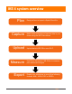
This document will guide you through:
Setting up your IKE system
Making in-eld measurement tasks
Transferring data from the IKE Field to IKE Ofce
Measuring attachment heights from a photo
Outputting data in industry standard le formats