
User Manual


157
Working with Terminal Charts
The Airport List is your primary resource for viewing terminal charts within your
coverage area. If you are not familiar with the Airport List, you may want to review
the topics in Working with the Airport List.
This section contains the following topics regarding terminal charts:
• Viewing the List of Airport Terminal Charts
• Finding VFR Area Charts (Europe VFR Only)
• Displaying a Terminal Chart
• Navigating in the Terminal Charts View
• Terminal Chart Filters
• Viewing Terminal Chart NOTAMs
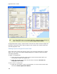
RoutePack Terminal Charts Right-Click Menu
To open the RoutePack terminal charts right-click menu, select any terminal chart in
the RoutePack List and right-click.
Cut
Removes the terminal chart from the airport and places it in the paste
buffer.
Copy
Copies the terminal chart into the paste buffer.
Paste
Inserts a terminal chart from the paste buffer in sequence before the
selected chart. (A terminal chart can be pasted inserted under the
airport with which it is associated).
Delete
Removes the terminal chart from the airport.
Print
Opens the Print dialog box allowing you to print the selected terminal
charts.
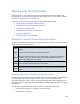
Viewing the List of Airport Terminal Charts
Each airport in the Airport List or RoutePack List has terminal charts associated with
it. These charts can include airspace, noise, arrival, airport, departure, and
instrument approach charts. Future, obsolete, and temporary charts might also be
included in the list. Terminal charts are sorted by number under the airport to which
they belong.
To view the list of terminal charts for an airport, do any of the following:
• Click the PLUS SIGN (+) to the left of the airport ID.
• Double-click an airport.